Though it reads like I might have, I didn't write the subject of this post. In the Dallas Morning News, Matt Lamster, the architecture critic, focuses on Museum Tower, but touches on the Arts District too. Added bonus, Lamster is a professor at my Alma Mater, UT-Arlington, which has a recognized architecture school.
The following are what I consider to be relevant points in the article.
The hot glare of contention has had the unfortunate effect of drawing
attention from what is rightly the building’s fundamental flaw.
Reflectivity issues, however serious, can be mitigated. But there’s no
easy way to alter Museum Tower’s essential nature as a gated vertical
community sequestered from the neighborhood that surrounds it.
...
It’s hard to imagine a less-urban urban building. Pushed back from the
street grid, Museum Tower stands at a remove behind stone walls, generic
landscaping and a barren, circular driveway. Think of it as an outpost
of the suburban bubble dropped into the heart of the city, where it does
not belong.
...
Just imagine what could have been: An engaging street presence with
retail options to benefit the entire neighborhood, its own inhabitants
included, and to encourage passage from the new deck park to the arts
institutions along Flora Street.
One Arts Plaza, the gridded
mixed-use tower at Flora’s northern terminus, at least makes some effort
in this direction, as will a pair of towers in development along Flora,
designed by Dallas-based HKS. A plan for artists’ housing on a site
adjacent to Museum Tower should also improve matters. But those projects
are no cure for Museum Tower, which saps vitality from the street.
On this score, the Nasher Sculpture Center, the principal victim of the
tower’s reflected rays, would do well to think about its own street
presence. The stone walls that shield Museum Tower were modeled on the
Nasher’s own ramparts. If the Arts District wants to be something more
than a bastion of privilege, it needs to come out from behind its walls.
...
The building was conceived as a standing sculpture, much like I.M.
Pei’s landmark Fountain Place, a model for Museum Tower. But Pei’s
prismatic tower is a far more rewarding form, a mutating, abstract
obelisk, and it is a wonder at the street, where its signature
fountains, designed by the seminal modernist landscape architect Dan
Kiley, remain a great urban amenity.
Museum Tower, by way of contrast, is a rather banal stalk and offers nothing back in terms of public space.
That
leads us to the barren driveway, minimally landscaped so pedestrians
might have an unencumbered view of the tower’s tapering 42 stories of
(brightly!) shining glass, its panels alternately fritted to add a bit
of animation. That facade slips up above the roofline, smartly occluding
mechanical equipment while emphasizing its verticality. The tower is
far less successful at the base, where it sits on a boxy pedestal that
has little relationship to the shaft, a problem that is especially acute
from its dreary Pearl Street backside — too much junk in the trunk, as
it were.
...
Museum Tower boasts all the amenities expected of a modern luxury
tower and many, in addition, that seem intended more for marketing
brochures than for actual residents.
Clubrooms and event spaces at
ground level, meant to promote community, will see light use at best.
Those same spaces should have been oriented to the street and programmed
to genuinely develop a sense of shared experience. Residents might be
happier with the convenience of a nice cafe or a grocer in the building —
let alone a pharmacy or a dry-cleaner — and the whole area would
benefit.
...
Such insularity is self-defeating and speaks to the building’s broader reluctance to engage with the surrounding community.
It’s
one thing to have a kennel and pet-grooming station and another to have
a private dog run, when Klyde Warren Park has one of its own directly
across the street. Are Museum Tower residents really too precious to
walk their dogs — or have their minions walk their dogs — in public?
Even Jackie O. took her dogs out in Central Park.
At Museum Tower,
exposure to the neighborhood is primarily visual, through the
fishbowl-style floor-to-ceiling windows that have been vogue in
contemporary apartment towers since Richard Meier ignited the trend in
the early aughts.
...
It is, for example, difficult to square a building that boasts of
“private estates in the sky” with any serious notion of green living.
While environmentally friendly development should always be encouraged,
there’s no escaping the perverse irony that Museum Tower’s theoretically
sustainable facade is scorching its neighbors. That’s not sustainable,
in any sense.
The only thing I would add is the similarities of Museum Tower to the four main performance venues. Aside from the reflective glare, they suffer the same anti-urban flaws that Lamster recognizes in Museum Tower. They have unneeded setbacks, useless landscaping, single-use designs, blank walls and attention-grabbing architecture that lacks urban substance.
Lamster mentions that Museum Tower inhibits the Arts District from becoming the 24-hour vibrant community it was planned. The problem is, the Arts District itself does that already.
Showing posts with label urban development. Show all posts
Showing posts with label urban development. Show all posts
Saturday, September 7, 2013


Saturday, September 8, 2012
The Raw Deal between Publically-Built Stadiums and Taxpayers
While I have touched on the way taxpayers get the wrong end of the deal when it comes to stadiums financed by municipalities, I tend to focus more on the claims of economic and urban development. To add another dimension of the debate against publically-financed stadiums, Bloomberg published an article detailing the way federal tax dollars are shifted away from the general revenue fund and into the owner's pockets.
I highly recommend the read, even though it is a bit longer. Essentially, cities "own" the stadiums and can finance them with tax-exempt bonds but the owner uses the stadium for free, keeps most-to-all of the revenue, and the treasury misses out of the funds they would have otherwise seen. These bonds were meant for true public uses, like schools or roads, but have been corrupted for gain by the privileged few who can afford to own teams.
As a contrast, Bloomberg offered up Cowboys Stadium, which opened in 2009 and cost $1.2 billion, to the home of the Giants, MetLife Stadium, which opened this year at a cost of $1.6 billion. The local venue used $350 million in public bonds, to be paid for in local taxes. The New York version was completely financed by the private sector.
I won't go into any more, because I don't want to steal the thunder of the article, as well as the authors are able to concisely detail the financials better than I could.
Ultimately, it feels like I am beating a dead horse here. As I have stated many times, I have yet to see an independent analysis that states how stadiums are a great deal for anyone but the owners. This is just another drop in that bucket.
I highly recommend the read, even though it is a bit longer. Essentially, cities "own" the stadiums and can finance them with tax-exempt bonds but the owner uses the stadium for free, keeps most-to-all of the revenue, and the treasury misses out of the funds they would have otherwise seen. These bonds were meant for true public uses, like schools or roads, but have been corrupted for gain by the privileged few who can afford to own teams.
As a contrast, Bloomberg offered up Cowboys Stadium, which opened in 2009 and cost $1.2 billion, to the home of the Giants, MetLife Stadium, which opened this year at a cost of $1.6 billion. The local venue used $350 million in public bonds, to be paid for in local taxes. The New York version was completely financed by the private sector.
I won't go into any more, because I don't want to steal the thunder of the article, as well as the authors are able to concisely detail the financials better than I could.
Ultimately, it feels like I am beating a dead horse here. As I have stated many times, I have yet to see an independent analysis that states how stadiums are a great deal for anyone but the owners. This is just another drop in that bucket.
Saturday, July 28, 2012
Oil and Water or Parking at Rail Stations
The expanding rail system in Denver is undergoing a fundamental rethink of how it gets it passengers to its rail system as detailed by the Wall Street Journal. There are some very relevant parts for Dallas and DART in there.
Here's the fundamental parts:
After the system opened in 1994, planners built parking lots and garages around many of its stations to cater to commuters. That strategy put parking on land that would have been ideal for stores, apartment buildings and squares catering to riders living adjacent to the stops.
As a result, there has been little of that kind of development around the stations to change the area's car-dependent culture, and riders commute to the stations from up to 20 miles away.
"Once you put in a parking structure, it's difficult to move it," says Bill Sirois, senior planning manager at the Regional Transportation District in Denver.
Denver-transit planners now are becoming more flexible when it comes to how much parking they require near rail stops and where they put it.
In the continuing expansion of the Denver rail system—which will add up to 122 miles of light rail and commuter rail lines to the existing 35 miles within the next 10 years—land adjacent to stations will be earmarked in some cases for village-type developments.
...
Whether to cater primarily to commuters or to residents near rail stops is a pivotal question for mass-transit planners in some cities. Many western cities expanding relatively young rail systems don't have the density or "walkability" that has allowed residents in older, Eastern cities such as New York to eschew cars in favor of mass transit.
Still, some of Denver's peer cities already have embraced this approach. San Francisco's Bay Area Rapid Transit, or BART, and the TriMet mass-transit system in Portland, Ore., long have favored relegating park-and-ride service to their farthest flung stations in the suburbs. Meanwhile, they encourage dense clusters of apartments, condominiums and offices adjacent to their urban rail stops. The twin cities of Minneapolis and St. Paul, Minn., have taken a similar approach recently.
...
Critics ask whether Denver's change in approach on parking will chase some riders away rather than attract them. "So, they're going to make it more difficult to use transit in hopes that the real-estate speculators who use public money to build these things can flourish?" asks Jon Caldara, president of the Independence Institute, a think tank in Denver. A former board member of Denver's transit system, Mr. Caldara long has been among its most vocal critics.
This something I have espoused for a long time. Why would any system that wants to redesign the urban landscape surround the instruments that accomplish that feat with pedestrian-deadening surface parking lots and single-use garages? If the goal is to redo our transportation system from a car-based one to one that sees a greater tendency for walking and transit, why does it virtually require a car for its use?
This, I believe, is a reflection of a different generation. The older planning set, as well as almost all of the political spectrum, see cars as either indispensable or inevitable, neither of which is accurate.
I've said it before and it is relevant here. People will do what is convenient. Americans don't have a love affair with the car. They have a forced marriage. Nothing else is convenient. Look at it in this case, parking lots immediately surrounding stations. Any attempt at redesigning the urban environment around it will be blunted because the parking is taking up the space that the urban environment needs to thrive. We made the car more convenient. So if there is a development there, the impact of seperating the rail station from it with parking will lower the everyday use of the rail system from the development, as well as from people outside the area who might travel to the development.
There are other endless examples of this. A few weeks ago, I talked about how signal timing is a virtual impossibility in an urban area. But what is being timed, whether urban, suburban or rural? Autos, at the expense of everything else. Why aren't the signals timed for bikes? Walking? Buses? All of these have a different speed. By picking the car, we are picking our preference.
What happens when a street is widened? Property is taken to account for that space. What was that property. In an urban area, where most property is flush with the property line, it is sidewalks (in outer areas, it can also be private property). What is the message that is sent when we narrow sidewalks to widen space for cars. The autos have priority over pedestrians.
Speaking of sidewalks, how often do neighborhoods, even close-in ones, have sidewalks? Anything less than 100 percent is too low. Can you imagine a neighborhood without roads? Even rural, farming communities have at least dirt ones. What is that message that is sent that the only infrastructure that was built was to accommodate cars? Cars take priority over anything else.
From 1945-1990, virtually every city large and small built at least one freeway and almost always many more. In the meantime, city transit systems languished. Those that were able to continue were almost always a bus, stuck in traffic (and facing signals not timed for them, slowing them down even more). No new investments were made in transit except in isolated cases. It wasn't until the 1990's that there were multiple cities with concrete additions on the ground.
Reverting back to the topic, it is clear that even when our transit systems were being designed, it was with the idea of the car first. In essence, we are investing in a transportation system not designed to be an alternative to the car, but rather shorten the distance cars make on each trip.
And the ironic part, is exactly what Bill Sirois touched on above. Unless we are talking surface lots, once these parking structures are in place, their stay is quite long, reducing not just the tendency to encourage alternative transportation now, but a long time into the future as well.
What Denver is doing in trying to encourage TOD's, what San Francisco did in allocating parking in the outlying areas is exactly what virtually every rail-building-transit agency should do. Why do the rail stations of Mockingbird, Park Lane, Victory (though the parking is not DART's property), Union (alos not DART's property) Market Center, Inwood, Bachman, 8th & Corinth, Illinois, MLK, Lawnview and White Rock Lake all have abundant parking? There are within five miles of Downtown Dallas, the first place that urbanism started in this area. Several are also near urban enclaves of varying degree. Now granted there are some urban stations, but more have parking than don't, even within Loop 12.
What critics like Jon Caldera fail to realize when they say things like without parking, it won't be used is that at some point, for that dynamic to change, there has to be a starting point. At some point, there will have to be a restriction of parking, there will have to a densification of the urban area.
It isn't because planners dislike cars, but rather out of every widespread transportation system there is, personal autos have the greatest amount of negative externalities, both public (pollution, health, cost, and land) and private (sedentary, cost, injury and death). If we know that, then why are cars put first above everything? It isn't because they are the most efficient or the most operable. New York City and the rest of the Alpha World Class Cities are proof of that. In NYC, walking is the most used transportation form, followed by transit. Cars are third. I'm not saying every city has to be the equivalent, but it would be better than what Dallas achieves, an 87 percent single use occupancy.
For DART, it has to achieve better than 32 stations out of 55 that are commuter-based, or 58 percent. If the the Downtown Dallas rail stations are removed, the percentage is raised to almost two-thirds. The Orange Line opens Monday and I don't know its numbers off the top of my head, though I believe only the Las Colinas Station serves the neighborhood, though the University of Dallas Station may too.
Where are the walkable neighborhoods? Where are the bus transfers? Where is the actual ability to live car-free? All these were promised during DART's referendum to form the agency in the 1980's. While there is a lot that the rail system lacks that is outside DART's control, this is something that could help the system that they have direct control over. In the end, they have to ask themselves do they want a transit system that serves the future of Dallas, or one that was built for the 1980's Dallas.
Here's the fundamental parts:
After the system opened in 1994, planners built parking lots and garages around many of its stations to cater to commuters. That strategy put parking on land that would have been ideal for stores, apartment buildings and squares catering to riders living adjacent to the stops.
As a result, there has been little of that kind of development around the stations to change the area's car-dependent culture, and riders commute to the stations from up to 20 miles away.
"Once you put in a parking structure, it's difficult to move it," says Bill Sirois, senior planning manager at the Regional Transportation District in Denver.
Denver-transit planners now are becoming more flexible when it comes to how much parking they require near rail stops and where they put it.
In the continuing expansion of the Denver rail system—which will add up to 122 miles of light rail and commuter rail lines to the existing 35 miles within the next 10 years—land adjacent to stations will be earmarked in some cases for village-type developments.
...
Whether to cater primarily to commuters or to residents near rail stops is a pivotal question for mass-transit planners in some cities. Many western cities expanding relatively young rail systems don't have the density or "walkability" that has allowed residents in older, Eastern cities such as New York to eschew cars in favor of mass transit.
Still, some of Denver's peer cities already have embraced this approach. San Francisco's Bay Area Rapid Transit, or BART, and the TriMet mass-transit system in Portland, Ore., long have favored relegating park-and-ride service to their farthest flung stations in the suburbs. Meanwhile, they encourage dense clusters of apartments, condominiums and offices adjacent to their urban rail stops. The twin cities of Minneapolis and St. Paul, Minn., have taken a similar approach recently.
...
Critics ask whether Denver's change in approach on parking will chase some riders away rather than attract them. "So, they're going to make it more difficult to use transit in hopes that the real-estate speculators who use public money to build these things can flourish?" asks Jon Caldara, president of the Independence Institute, a think tank in Denver. A former board member of Denver's transit system, Mr. Caldara long has been among its most vocal critics.
This something I have espoused for a long time. Why would any system that wants to redesign the urban landscape surround the instruments that accomplish that feat with pedestrian-deadening surface parking lots and single-use garages? If the goal is to redo our transportation system from a car-based one to one that sees a greater tendency for walking and transit, why does it virtually require a car for its use?
This, I believe, is a reflection of a different generation. The older planning set, as well as almost all of the political spectrum, see cars as either indispensable or inevitable, neither of which is accurate.
I've said it before and it is relevant here. People will do what is convenient. Americans don't have a love affair with the car. They have a forced marriage. Nothing else is convenient. Look at it in this case, parking lots immediately surrounding stations. Any attempt at redesigning the urban environment around it will be blunted because the parking is taking up the space that the urban environment needs to thrive. We made the car more convenient. So if there is a development there, the impact of seperating the rail station from it with parking will lower the everyday use of the rail system from the development, as well as from people outside the area who might travel to the development.
There are other endless examples of this. A few weeks ago, I talked about how signal timing is a virtual impossibility in an urban area. But what is being timed, whether urban, suburban or rural? Autos, at the expense of everything else. Why aren't the signals timed for bikes? Walking? Buses? All of these have a different speed. By picking the car, we are picking our preference.
What happens when a street is widened? Property is taken to account for that space. What was that property. In an urban area, where most property is flush with the property line, it is sidewalks (in outer areas, it can also be private property). What is the message that is sent when we narrow sidewalks to widen space for cars. The autos have priority over pedestrians.
Speaking of sidewalks, how often do neighborhoods, even close-in ones, have sidewalks? Anything less than 100 percent is too low. Can you imagine a neighborhood without roads? Even rural, farming communities have at least dirt ones. What is that message that is sent that the only infrastructure that was built was to accommodate cars? Cars take priority over anything else.
From 1945-1990, virtually every city large and small built at least one freeway and almost always many more. In the meantime, city transit systems languished. Those that were able to continue were almost always a bus, stuck in traffic (and facing signals not timed for them, slowing them down even more). No new investments were made in transit except in isolated cases. It wasn't until the 1990's that there were multiple cities with concrete additions on the ground.
Reverting back to the topic, it is clear that even when our transit systems were being designed, it was with the idea of the car first. In essence, we are investing in a transportation system not designed to be an alternative to the car, but rather shorten the distance cars make on each trip.
And the ironic part, is exactly what Bill Sirois touched on above. Unless we are talking surface lots, once these parking structures are in place, their stay is quite long, reducing not just the tendency to encourage alternative transportation now, but a long time into the future as well.
What Denver is doing in trying to encourage TOD's, what San Francisco did in allocating parking in the outlying areas is exactly what virtually every rail-building-transit agency should do. Why do the rail stations of Mockingbird, Park Lane, Victory (though the parking is not DART's property), Union (alos not DART's property) Market Center, Inwood, Bachman, 8th & Corinth, Illinois, MLK, Lawnview and White Rock Lake all have abundant parking? There are within five miles of Downtown Dallas, the first place that urbanism started in this area. Several are also near urban enclaves of varying degree. Now granted there are some urban stations, but more have parking than don't, even within Loop 12.
What critics like Jon Caldera fail to realize when they say things like without parking, it won't be used is that at some point, for that dynamic to change, there has to be a starting point. At some point, there will have to be a restriction of parking, there will have to a densification of the urban area.
It isn't because planners dislike cars, but rather out of every widespread transportation system there is, personal autos have the greatest amount of negative externalities, both public (pollution, health, cost, and land) and private (sedentary, cost, injury and death). If we know that, then why are cars put first above everything? It isn't because they are the most efficient or the most operable. New York City and the rest of the Alpha World Class Cities are proof of that. In NYC, walking is the most used transportation form, followed by transit. Cars are third. I'm not saying every city has to be the equivalent, but it would be better than what Dallas achieves, an 87 percent single use occupancy.
For DART, it has to achieve better than 32 stations out of 55 that are commuter-based, or 58 percent. If the the Downtown Dallas rail stations are removed, the percentage is raised to almost two-thirds. The Orange Line opens Monday and I don't know its numbers off the top of my head, though I believe only the Las Colinas Station serves the neighborhood, though the University of Dallas Station may too.
Where are the walkable neighborhoods? Where are the bus transfers? Where is the actual ability to live car-free? All these were promised during DART's referendum to form the agency in the 1980's. While there is a lot that the rail system lacks that is outside DART's control, this is something that could help the system that they have direct control over. In the end, they have to ask themselves do they want a transit system that serves the future of Dallas, or one that was built for the 1980's Dallas.
Sunday, July 15, 2012
Retail Targets for Downtown Dallas
There is a prevalent idea around these parts about just what kind of retail needs to exist in the urban core. The basic premise is that Downtown Dallas can't compete with the suburbs on a one-to-one basis. So, in order to attract customers, the retail and restaurant offerings have to be unique, and not available anywhere else in the region.
This line of thinking makes a lot of sense and I don't disagree with it entirely. The thinking is that someone won't pass by three Gap's to get to one located Downtown. However, I do believe this is an overly simplistic, and in some cases archaic, view.
First, this assumes that everyone lives far away from Downtown. As more and more people live in the urban core, this is less and less and issue. People who live in the core have similar desires and consumption habits as their affluent suburban counterparts.
The idea of only destination retail Downtown also suffers from a lack of context when it comes to urban design. Classic urban design areas have withstood the test of time, literally many millennia. Meanwhile, the typical shopping mall and strip center have a lifespan of only several decades. On top of that, preferences for building and patronizing these places has fallen over the years, in favor of...more urban style developments. So for some folks, they'd rather drive past all the other Old Navy's or Olive Garden's. So, if from that angle, is it reasonable to assume that "average" retail offerings would be appealing in Downtown?
An obvious flaw with destination retail is the price point. Urban areas are supposed to be all-inclusive. If the retail and restaurant products require a hefty penny, that excludes all lower-class folks and most middle-class people as well. If what we are encouraging actually encourages people to not patronize the area, reducing its vibrancy, isn't that fundamentally backwards?
This is one of the main reasons, especially outside of the urban design, that Victory struggled.
One of the biggest impediments, once again excluding current urban design, is the transportation system. There are three conflicting issues that make Downtown Dallas inconvenient.
1) The city's urban core was built prior to the automobile. This meant the urban area was based around walking and then transit (specifically the streetcar). Even after the automobile was introduced and into the first couple of decades of the 20th century, the design stayed steady. Therefore, most everything within a three mile radius of downtown is still based on this mode.
2) In an effort to modernize Downtown for the car, planners and traffic engineers shoehorned in a freeway system with wide roads to facilitate travel to the freeways, decimating parts of the urban environment. However, these additions did not make Downtown auto-friendly, further complicating the local transportation system. It is no longer as transit-friendly, the auto additions alienated the pedestrian and Downtown is still not as car-friendly as the suburbs, which were built with cars as the priority.
3) The transportation system helped foster in a transition from mixed-use to office park. This saw large scale evacuation of a varied retail landscape in Downtown.
So, as it stands right now, Downtown is inconvenient to drive to, taking transit is inconsistent and walking came be uncomfortable. Tell me why any business would locate here?
I initially started pondering this idea when I thought of just how many unique places that were opened in redeveloped buildings had closed: a wine-crafter in the Davis Building, several versions of a club in the old bank vault within the Davis, a furniture store in the Davis, a knick-knack shop in the Kirby, a clothier in DP&L, and numerous restaurants not found anywhere else. So if the thought is we can't do more common retail and unique retail can't stay open, what are we to do? The answer in just a moment.
But first, I don't want this to come off like I am pro-chain and anti-local, though in a region as large as this those labels aren't so concise. Some of my family's most common destinations are local. However, there are large amounts of people who don't prefer something that they don't know.
I think the answer, then, has to be that Downtown include some of everything, especially if we as a city can remedy the transit problem. If more of the retail locates along the transit mall in downtown, it becomes really convenient.
Think back to our modern shopping areas. There is usually a mix of destination and common retail. Downtown Dallas was the original outdoor shopping mall. If we can reintroduce that proper mix of retail, I believe can be again.
This line of thinking makes a lot of sense and I don't disagree with it entirely. The thinking is that someone won't pass by three Gap's to get to one located Downtown. However, I do believe this is an overly simplistic, and in some cases archaic, view.
First, this assumes that everyone lives far away from Downtown. As more and more people live in the urban core, this is less and less and issue. People who live in the core have similar desires and consumption habits as their affluent suburban counterparts.
The idea of only destination retail Downtown also suffers from a lack of context when it comes to urban design. Classic urban design areas have withstood the test of time, literally many millennia. Meanwhile, the typical shopping mall and strip center have a lifespan of only several decades. On top of that, preferences for building and patronizing these places has fallen over the years, in favor of...more urban style developments. So for some folks, they'd rather drive past all the other Old Navy's or Olive Garden's. So, if from that angle, is it reasonable to assume that "average" retail offerings would be appealing in Downtown?
An obvious flaw with destination retail is the price point. Urban areas are supposed to be all-inclusive. If the retail and restaurant products require a hefty penny, that excludes all lower-class folks and most middle-class people as well. If what we are encouraging actually encourages people to not patronize the area, reducing its vibrancy, isn't that fundamentally backwards?
This is one of the main reasons, especially outside of the urban design, that Victory struggled.
One of the biggest impediments, once again excluding current urban design, is the transportation system. There are three conflicting issues that make Downtown Dallas inconvenient.
1) The city's urban core was built prior to the automobile. This meant the urban area was based around walking and then transit (specifically the streetcar). Even after the automobile was introduced and into the first couple of decades of the 20th century, the design stayed steady. Therefore, most everything within a three mile radius of downtown is still based on this mode.
2) In an effort to modernize Downtown for the car, planners and traffic engineers shoehorned in a freeway system with wide roads to facilitate travel to the freeways, decimating parts of the urban environment. However, these additions did not make Downtown auto-friendly, further complicating the local transportation system. It is no longer as transit-friendly, the auto additions alienated the pedestrian and Downtown is still not as car-friendly as the suburbs, which were built with cars as the priority.
3) The transportation system helped foster in a transition from mixed-use to office park. This saw large scale evacuation of a varied retail landscape in Downtown.
So, as it stands right now, Downtown is inconvenient to drive to, taking transit is inconsistent and walking came be uncomfortable. Tell me why any business would locate here?
I initially started pondering this idea when I thought of just how many unique places that were opened in redeveloped buildings had closed: a wine-crafter in the Davis Building, several versions of a club in the old bank vault within the Davis, a furniture store in the Davis, a knick-knack shop in the Kirby, a clothier in DP&L, and numerous restaurants not found anywhere else. So if the thought is we can't do more common retail and unique retail can't stay open, what are we to do? The answer in just a moment.
But first, I don't want this to come off like I am pro-chain and anti-local, though in a region as large as this those labels aren't so concise. Some of my family's most common destinations are local. However, there are large amounts of people who don't prefer something that they don't know.
I think the answer, then, has to be that Downtown include some of everything, especially if we as a city can remedy the transit problem. If more of the retail locates along the transit mall in downtown, it becomes really convenient.
Think back to our modern shopping areas. There is usually a mix of destination and common retail. Downtown Dallas was the original outdoor shopping mall. If we can reintroduce that proper mix of retail, I believe can be again.
Monday, June 11, 2012
Teardown as a Freeway Mitigation
A week ago, I posted a brief tour of various cities negative freeway effects. Some of those cities have instituted a few mitigation programs to minimize or eliminate their effects. Freeway demolition is a tool that is sparingly used, but as freeways approach the end of their usable lifespan, it is receiving a lot more attention.
A construction disaster collapsed the West Side Highway in New York. By policy, Portland lost Harbor Drive and Milwaukee demoed the Park East Freeway. An earthquake helped remove the Embarcadero Freeway. New Orleans is considering demoing the Claiborne Expressway (I-10) and back in New York, the Sheridan Expressway (I-895) is facing an uncertain future about its existence.
The one common thread through these examples is the relatively short freeway lengths. These were small spurs through the urban environment. However, another city may become the greatest freeway removal example to those promoting the urban benefits.
In the fourth example I gave in the case study post above, Baltimore's I-83, the Jones Falls Expressway, as a perfect example of an urban divider, separating the city from its parks. Well, turns out there is a movement afoot to remove it.
There are two options mentioned. The first was the typical stub. Less that a mile of the roughly 10-mile long freeway would meet the wrecking ball. For the map-inclined folks like myself, that is from Fayetteville St to Chase St in Downtown Baltimore.
Since it isn't Dallas related, I likely wouldn't have posted this if it was just that portion, especially since this proposal (I even think it is too early to call it a proposal) is still in the infant stage. What I want to post is that for the first time, an entire freeway is being talked about for removal.
In a sixty-page PowerPoint entitled "Fallsway: A New Downtown Neighborhood for Baltimore, MD," Edison shows the taking down of the JFX as key to redeveloping an area that would reach east to the blighted Old Town neighborhood (and beyond that to Hopkins Hospital) and west to Mount Vernon and the Downtown business district.
Johns Hopkins Health Care Center is at the complete opposite end of the 10-mile highway. That is huge!
There is a directly parallel light rail line (MTA's Blue Line) six miles from Downtown. It is less than a mile away for the rest of the route. The only area this rail line doesn't serve that the freeway does is the hospital, but a bus route does (poor frequency would have to be addressed) and connects to both the Blue Line and the Heavy Rail Line that is color coded green. This would help transit use soar in this area.
Downtown's built environment would be helped out by either proposal, but just the idea of tackling a freeway removal in an outer area is virgin territory. It is just in the beginning of preliminary talks, but if this were to happen, the momentum of freeway removal will be huge.
A construction disaster collapsed the West Side Highway in New York. By policy, Portland lost Harbor Drive and Milwaukee demoed the Park East Freeway. An earthquake helped remove the Embarcadero Freeway. New Orleans is considering demoing the Claiborne Expressway (I-10) and back in New York, the Sheridan Expressway (I-895) is facing an uncertain future about its existence.
The one common thread through these examples is the relatively short freeway lengths. These were small spurs through the urban environment. However, another city may become the greatest freeway removal example to those promoting the urban benefits.
In the fourth example I gave in the case study post above, Baltimore's I-83, the Jones Falls Expressway, as a perfect example of an urban divider, separating the city from its parks. Well, turns out there is a movement afoot to remove it.
There are two options mentioned. The first was the typical stub. Less that a mile of the roughly 10-mile long freeway would meet the wrecking ball. For the map-inclined folks like myself, that is from Fayetteville St to Chase St in Downtown Baltimore.
Since it isn't Dallas related, I likely wouldn't have posted this if it was just that portion, especially since this proposal (I even think it is too early to call it a proposal) is still in the infant stage. What I want to post is that for the first time, an entire freeway is being talked about for removal.
In a sixty-page PowerPoint entitled "Fallsway: A New Downtown Neighborhood for Baltimore, MD," Edison shows the taking down of the JFX as key to redeveloping an area that would reach east to the blighted Old Town neighborhood (and beyond that to Hopkins Hospital) and west to Mount Vernon and the Downtown business district.
Johns Hopkins Health Care Center is at the complete opposite end of the 10-mile highway. That is huge!
 |
| The before shot. Note the clear deliniation of either side of the highway. There isn't a much clearer example of a freeway dividing the urban landscape. Add the fact that it is elevated and the pedestrian sure feels the division. |
There is a directly parallel light rail line (MTA's Blue Line) six miles from Downtown. It is less than a mile away for the rest of the route. The only area this rail line doesn't serve that the freeway does is the hospital, but a bus route does (poor frequency would have to be addressed) and connects to both the Blue Line and the Heavy Rail Line that is color coded green. This would help transit use soar in this area.
 |
| The after. While there is still a clear visual seperation, the addition of parks and a taming of the street, not to mention the addition of urban buildings, will make the area near-seamless to the urban user. |
Tuesday, April 24, 2012
My Ideas for Uptown (long)
If you were to peruse my previous 90+ posts, there would be a consistent topic or model. Downtown Dallas is the most used example to make many of my points. It is the center of the local urban area and the neighborhood where I call home. But, adjacent to Downtown is Uptown, which is more urban than Downtown in almost every way. So today, I am going to look at Downtown's northern neighbor.
This is going to be hard for me because I have conflicting thoughts here. The first is that I recognize Uptown is the most urban neighborhood in Dallas, and probably the region. The only area that comes close is Downtown Fort Worth. Each is better than the other in some categories, so it is hard to say which one is the best, which is also somewhat of a subjective measure anyway.
However, here's the conflicting thoughts. I have often wondered if I let the idea of a perfect or great get in the way of good. There is a lot going for Uptown. But, it could be better. It does encourage people to walk, which is close to the epitome of what an urban area should be. Is it perfect? Of course not, but it is better than 99% of the region.
Am I an optimist who sees how things can be better, or am I the pessimist who sees what is wrong?
That said, here's what I think of Uptown., whose boundaries are Woodall Rogers on the south, U.S. 75 on the east, Blackburn on the northeast, the Katy Trail on the northwest and I-35 at the Katy Trail bend.
First, the balance of activity in Uptown is on the east side around McKinney. In the lower half of Uptown, Cedar Springs runs down the middle. So why the disparity? Why does the wstern half of Uptown feel like a sleepy burg while the eastern side feels like a city.
The answer lies with the street grid, primarily the two main streets of the area. McKinney on the east is narrow and exhibits many pedestrian-friendly designs. Cedar Springs is wide, made for getting as many cars through as possible and conjures feelings of playing a live Frogger game for anyone not driving.
The two photographs illustrate a lot of what is right about McKinney Street. There is the obvious with the streetcar tracks. These are known to slow traffic. Also notice how the street is narrow. There are still four lanes of traffic, but because they aren't so wide, drivers don't feel as comfortable at higher speeds and behavorially slow down.
There are also several design features that favor pedestrians over vehicles. Notice the trees and poles so very close to the curb. That, in lieu of on-street parking, creates a barrier between moving traffic and the pedestrian. Those trees are also an amenity during warm summer months. There are also things like benches, trash cans and signage that make life as a pedestrian more comfortable and easier to navigate. While the sidewalks aren't great, they are at least wide enough in most places to accommodate more than two people shoulder-to-shoulder.
Now compare the above with Cedar Springs.
Notice how wide this street is. Despite having the same amount of through lanes, Cedar Springs is roughly 50 percent wider. Each lane is one-two feet wider and there is also a center turning lane. Since the street is made for automobiles, there are no trees near the curb, primarily because traffic engineers deem them a hazard (more on that point in a moment). The sidewalks are narrow. There are no amenities like shade or benches. Buffer zones like on-street parking, poles or the aforementioned trees aren't anywhere to be seen. There isn't even local transit service.
Now take that second picture. This is an intersection. By state law, at an unsigned intersection or in a marked pedestrian crossing, the pedestrian always has the right-of-way. In the real world, this feels like playing chicken just to cross the road. There are no people in the pictures, because this road isn't designed for them.
That's a point I want to make when it comes to transportation in urban areas. McKinney and Cedar Springs have similar traffic counts. So that begs the question, why do we design our streets for cars. In the first set of pictures, there are cars, just like the second. However, there are no pedestrians, cyclists or transit users in the second. So if we can design the streets for everyone by making ifocusing the design towards a pedestrian-oriented feel, why do we continue to allow streets that are car designed that exclude everything else in the urban area?
Part of the reason, is that traffic engineers, who control street design regardless of location, have an inordinate amount of influence. So for example, to them, trees next to the curb represents a hazard for cars. Yet, they don't or can't realize that 1) it is an amenity to pedestrians and 2) that gives drivers a greater sense of danger at higher speeds and they therefore slow down, mitigating much of the danger they represent. In fact, some digging of actual traffic accidents and fatalities stats would reveal that the "safer" streets and intersections preached in the traffic manuals are actually the unsafe ones. They give drivers a sense safety and when that happens, we as humans naturally go fast and start to go through the motions. The "unsafe" examples actually have fewer accidents. Why this isn't more known or a bigger issue in city and urban design is beyond me.
That example is seen in these two streets. There are more accidents on Cedar Springs than McKinney. There have also been multiple pedestrian fatalities on Cedar Springs this year.
Interestingly enough, in the late '70's and early '80's, the traffic engineers wanted to expand McKinney and make it three lanes in each direction. Thankfully, there was enough push back from stakeholders that instead the streetcar line was pursued. I shudder to think of what Uptown would be like today if McKinney resembled Cedar Springs.
My recommendations to fix Cedar Springs would be to remove the center turn lane, narrow the lanes, widen the sidewalk and add on-street metered parking. Other than widen sidewalks, I like McKinney as it is.
On a similar, infrastructure note, it is amazing to me how even in Uptown, some streets do not have sidewalks.
I think the recommendation is clear. Even though Howland in not a major street, there should be no street in any urban area that has no sidewalk.
The next issue that I think is holding the area back even further may be the hardest to remediate. Like much of Downtown, the building stock of the 70's and 80's (what an awful time for urbanity) hold back the walkability of the area. Part of the reason that Uptown doesn't suffer the malaise that Downtown does is twofold: the lack of empty spaces (like parking lots) resulting from demolition of existing buildings for spec office buildings and that the buildings not built during the booms were usually built pre-car. The buildings built in the last 10-20 years have generally had respect for the street. But, there are still large parts of Uptown that contribute nothing to the urban environment.
Sadly, the exception to the newer buildings respecting the street can be seen in the Lower McKinney portion of Uptown. Starting at Maple and heading south, each building is like Downtown's urban area. Great individual buildings from afar that are empty at the street, by design. The trend was started in the '80's with the Crescent Complex. The architecture critic for The Dallas Morning News, David Dillon, called this block an attempt to combine the best of both the urban and suburban realms and fails in both.
Continuing that trend, in no particular order, were Ritz Carlton, 1999 McKinney, Uptown Plaza, 2000 McKinney, Texas Capital Bank, Advancial Tower, 2200 McKinney, Granite and so on. Crossing Maple Street is like crossing into a totally different city neighborhood.
Thankfully, there are only a smattering of these buildings further north and the area is dominated by low-rise urban buildings. West Village has contributed to a positive street scene in the north part of the area. Other parts aren't so successful. The Quadrangle is active, but not vibrant, a throwback to all the poor planning ideas of the time: parking out front, landscaped setbacks and single-use zoning.
The office building may be a little harder to retrofit, given the topography and current configuration, but the retail building may be more cost effective to demo and start over. Market pressures alone may make that happen. One positive I can say is I like the retail variety in the Quadrangle. There is a variety of restaurants, a liquor store, wine maker and theater. Hopefully any redevelopment could reincorporate these establishments, or maintain the variety.
The poor design can be seen in sporadically throughout the rest of neighborhood, but this smattering suppresses many of its negative qualities. There is no critical mass of urban vacuum here like there is in a "newer" development like Las Colinas. However, reflecting the transportation system, the Cedar Springs corridor has the highest concentration of these building.
While a remodel isn't impossible, getting these buildings, with large lobbies and ample setback, to respect the street is an expensive proposition.
It is important to note that this coming recommendation will not solve the problem, only prevent future ones from appearing. Most cities are reactive in their zoning, saying what will be allowed. I would argue for a form-based code for most or all of the area. This is important because this is the zoning code that most accurately reflects organic city building. This dictates what is not allowed, usually in the form of the building. You can build office, retail, residential, entertainment as long as it looks like X. It can not have Y setback, be Z feet tall or have W feet of blank sidewalk space, but others, do what you want. If done right, it can ensure proper urban-design guidelines while giving the private sector developers the freedom to build what they see fit.
As I said, this wouldn't fix the office examples above, but enacting it would make surethey will be the last ones with overtly negative effects.
Finally, as I was out and about, I noticed a scene that I had touched on before.
I am still undecided on how I feel. The same feelings I had before still exist. Had the area been done right before, these would be unneeded. However, since we are here and moving forward, they add a certain flair to an unused area of the neighborhood, even if just temporary. I will say, I am moving more towards being in favor of these, if for no other reason than the transient nature of food trucks allow for something better if it were to come along.
The last thing about Uptown is a bit redundant from a previous post I made. So instead of detailing the area's transit shortcomings and suggesting my ideas, I'll just give the link.
While the tone of this post is about what needs changing, let me devote the rest of this piece to what they do right. Upper McKinney Avenue reflects a wide range of architectural styles and transportation elements. There is a good combination of small, medium and large buildings of many uses that reflect a wide range of activities at all hours of the day and week. Cityplace Co. has demonstrated that Dallas developers do have the ability to design great urban spaces. The City needs to keep that going and make it a template for the rest of the area.
There is a great variety of retail and restaurant offerings. In large part because of West Village, but Gables managed properties have excelled at this too. Of course, the older buildings were already made that way and still function as such.
The mix of uses is close to, if not the best, of any urban area in the region. Aside from industrial, just about everything is represented. Overall, the approach to this neighborhood should be replicated that yielded these results. It is a great way to increase the tax base, lower the infrastructure costs and limit the environmental impact.
There, I can be positive, though I am still conflicted as to what I actually feel about this neighborhood.
This is going to be hard for me because I have conflicting thoughts here. The first is that I recognize Uptown is the most urban neighborhood in Dallas, and probably the region. The only area that comes close is Downtown Fort Worth. Each is better than the other in some categories, so it is hard to say which one is the best, which is also somewhat of a subjective measure anyway.
However, here's the conflicting thoughts. I have often wondered if I let the idea of a perfect or great get in the way of good. There is a lot going for Uptown. But, it could be better. It does encourage people to walk, which is close to the epitome of what an urban area should be. Is it perfect? Of course not, but it is better than 99% of the region.
Am I an optimist who sees how things can be better, or am I the pessimist who sees what is wrong?
That said, here's what I think of Uptown., whose boundaries are Woodall Rogers on the south, U.S. 75 on the east, Blackburn on the northeast, the Katy Trail on the northwest and I-35 at the Katy Trail bend.
First, the balance of activity in Uptown is on the east side around McKinney. In the lower half of Uptown, Cedar Springs runs down the middle. So why the disparity? Why does the wstern half of Uptown feel like a sleepy burg while the eastern side feels like a city.
The answer lies with the street grid, primarily the two main streets of the area. McKinney on the east is narrow and exhibits many pedestrian-friendly designs. Cedar Springs is wide, made for getting as many cars through as possible and conjures feelings of playing a live Frogger game for anyone not driving.
 |
| McKinney and Boll St looking north |
 |
| McKinney and Fairmount St looking north |
The two photographs illustrate a lot of what is right about McKinney Street. There is the obvious with the streetcar tracks. These are known to slow traffic. Also notice how the street is narrow. There are still four lanes of traffic, but because they aren't so wide, drivers don't feel as comfortable at higher speeds and behavorially slow down.
There are also several design features that favor pedestrians over vehicles. Notice the trees and poles so very close to the curb. That, in lieu of on-street parking, creates a barrier between moving traffic and the pedestrian. Those trees are also an amenity during warm summer months. There are also things like benches, trash cans and signage that make life as a pedestrian more comfortable and easier to navigate. While the sidewalks aren't great, they are at least wide enough in most places to accommodate more than two people shoulder-to-shoulder.
Now compare the above with Cedar Springs.
 |
| Cedar Springs and Routh St, looking north. |
 |
| Cedar Springs and Routh St, looking west. Would you want to get to the other side? |
Now take that second picture. This is an intersection. By state law, at an unsigned intersection or in a marked pedestrian crossing, the pedestrian always has the right-of-way. In the real world, this feels like playing chicken just to cross the road. There are no people in the pictures, because this road isn't designed for them.
That's a point I want to make when it comes to transportation in urban areas. McKinney and Cedar Springs have similar traffic counts. So that begs the question, why do we design our streets for cars. In the first set of pictures, there are cars, just like the second. However, there are no pedestrians, cyclists or transit users in the second. So if we can design the streets for everyone by making ifocusing the design towards a pedestrian-oriented feel, why do we continue to allow streets that are car designed that exclude everything else in the urban area?
Part of the reason, is that traffic engineers, who control street design regardless of location, have an inordinate amount of influence. So for example, to them, trees next to the curb represents a hazard for cars. Yet, they don't or can't realize that 1) it is an amenity to pedestrians and 2) that gives drivers a greater sense of danger at higher speeds and they therefore slow down, mitigating much of the danger they represent. In fact, some digging of actual traffic accidents and fatalities stats would reveal that the "safer" streets and intersections preached in the traffic manuals are actually the unsafe ones. They give drivers a sense safety and when that happens, we as humans naturally go fast and start to go through the motions. The "unsafe" examples actually have fewer accidents. Why this isn't more known or a bigger issue in city and urban design is beyond me.
That example is seen in these two streets. There are more accidents on Cedar Springs than McKinney. There have also been multiple pedestrian fatalities on Cedar Springs this year.
Interestingly enough, in the late '70's and early '80's, the traffic engineers wanted to expand McKinney and make it three lanes in each direction. Thankfully, there was enough push back from stakeholders that instead the streetcar line was pursued. I shudder to think of what Uptown would be like today if McKinney resembled Cedar Springs.
My recommendations to fix Cedar Springs would be to remove the center turn lane, narrow the lanes, widen the sidewalk and add on-street metered parking. Other than widen sidewalks, I like McKinney as it is.
On a similar, infrastructure note, it is amazing to me how even in Uptown, some streets do not have sidewalks.
 |
| This part of Howland Street has no sidewalk. |
The next issue that I think is holding the area back even further may be the hardest to remediate. Like much of Downtown, the building stock of the 70's and 80's (what an awful time for urbanity) hold back the walkability of the area. Part of the reason that Uptown doesn't suffer the malaise that Downtown does is twofold: the lack of empty spaces (like parking lots) resulting from demolition of existing buildings for spec office buildings and that the buildings not built during the booms were usually built pre-car. The buildings built in the last 10-20 years have generally had respect for the street. But, there are still large parts of Uptown that contribute nothing to the urban environment.
Sadly, the exception to the newer buildings respecting the street can be seen in the Lower McKinney portion of Uptown. Starting at Maple and heading south, each building is like Downtown's urban area. Great individual buildings from afar that are empty at the street, by design. The trend was started in the '80's with the Crescent Complex. The architecture critic for The Dallas Morning News, David Dillon, called this block an attempt to combine the best of both the urban and suburban realms and fails in both.
 |
| The huge setbacks and ample parking out front make this complex a ghost town for pedestrians. |
Thankfully, there are only a smattering of these buildings further north and the area is dominated by low-rise urban buildings. West Village has contributed to a positive street scene in the north part of the area. Other parts aren't so successful. The Quadrangle is active, but not vibrant, a throwback to all the poor planning ideas of the time: parking out front, landscaped setbacks and single-use zoning.
 |
| Is this in an urban area or a strip shopping center near a freeway? |
 |
| The namesake office building; unless one offices here, there is no reason to be here. |
The poor design can be seen in sporadically throughout the rest of neighborhood, but this smattering suppresses many of its negative qualities. There is no critical mass of urban vacuum here like there is in a "newer" development like Las Colinas. However, reflecting the transportation system, the Cedar Springs corridor has the highest concentration of these building.
 |
| Nothing for the pedestrian, and so few parking spaces that a only a select few can benefit. This building effectively isolates the building user and the passing pedestrian, getting no benefit for either. |
 |
| An example of a good urban building along Cedar Springs, doors opening onto the street with a minimum setback. |
 |
| This is the two working against each other. The two-story doesn't generate enough foot traffic on its own and the larger commercial building generates next to nothing. In the end, the bad urban building is bringing down the good. |
It is important to note that this coming recommendation will not solve the problem, only prevent future ones from appearing. Most cities are reactive in their zoning, saying what will be allowed. I would argue for a form-based code for most or all of the area. This is important because this is the zoning code that most accurately reflects organic city building. This dictates what is not allowed, usually in the form of the building. You can build office, retail, residential, entertainment as long as it looks like X. It can not have Y setback, be Z feet tall or have W feet of blank sidewalk space, but others, do what you want. If done right, it can ensure proper urban-design guidelines while giving the private sector developers the freedom to build what they see fit.
As I said, this wouldn't fix the office examples above, but enacting it would make surethey will be the last ones with overtly negative effects.
Finally, as I was out and about, I noticed a scene that I had touched on before.
 |
| In a vacant lot off of Routh Street, we have a food truck court. |
The last thing about Uptown is a bit redundant from a previous post I made. So instead of detailing the area's transit shortcomings and suggesting my ideas, I'll just give the link.
While the tone of this post is about what needs changing, let me devote the rest of this piece to what they do right. Upper McKinney Avenue reflects a wide range of architectural styles and transportation elements. There is a good combination of small, medium and large buildings of many uses that reflect a wide range of activities at all hours of the day and week. Cityplace Co. has demonstrated that Dallas developers do have the ability to design great urban spaces. The City needs to keep that going and make it a template for the rest of the area.
There is a great variety of retail and restaurant offerings. In large part because of West Village, but Gables managed properties have excelled at this too. Of course, the older buildings were already made that way and still function as such.
The mix of uses is close to, if not the best, of any urban area in the region. Aside from industrial, just about everything is represented. Overall, the approach to this neighborhood should be replicated that yielded these results. It is a great way to increase the tax base, lower the infrastructure costs and limit the environmental impact.
There, I can be positive, though I am still conflicted as to what I actually feel about this neighborhood.
Monday, April 23, 2012
Saving the Past
Early plans are in the works to convert the currently vacant Tower Petroleum and Corrigan Tower into residential buildings. These two are right across the street from the building my family lives in at this time, so I have taken an active interest in these two buildings for some time.
I have avoided posting about this at first because I don't feel I am a news source. I try to stay more towards the editorial side. However, after thinking it over, I think there is one very important thing that can be learned from this.
Several years ago, there was a proposal to convert the Tower Petroleum to a hotel and demo the Corrigan Tower to make way for a 50-story condo tower. The reason given was that the Corrigan Tower was beyond saving (see post #188 here).
This is the point I want to make. I am a historic preservation advocate. From a cultural perspective (seeing where we came from), from an urban design perspective (old buildings are usually more urban than new) and from a lost perspective (when it is gone, it can never return), I generally side on the case that preservation is paramount, especially when you consider that Dallas' downtown is not short on open, empty or vacant land. Destroying a building when there is a parking lot across the street is a net loss to society and the area.
Back to this particular story. I always suggest taking the idea of demolitions with a critical eye. In this case, there is a developer who wants to do it right. He sees the value in this building. Oftentimes, people look at architecture from the '50's and '60's and say they are ugly and need to be demoed. While I don't disagree with the first, I do with the second. There was a time when Dallasites thought Old Red Courthouse was ugly and needed to be razed. Nowadays, this building is considered a gem. While I sometimes wonder if these buildings will ever be considered beautiful again, I do know they need to be carried over until the next generation, if for no other reason than to avoid a situtation like Old Red.
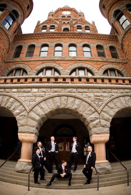
There is almost always a way to make an old building work. Sometimes there are cost issues and that's where I would say local governments can help with TIF payments, tax abatements or other incentives. But often times the developer just wants a blank slate and will say it can't be saved. That may be okay for them, their architect, but for the rest of us, we don't come out ahead.
I have avoided posting about this at first because I don't feel I am a news source. I try to stay more towards the editorial side. However, after thinking it over, I think there is one very important thing that can be learned from this.
Several years ago, there was a proposal to convert the Tower Petroleum to a hotel and demo the Corrigan Tower to make way for a 50-story condo tower. The reason given was that the Corrigan Tower was beyond saving (see post #188 here).
This is the point I want to make. I am a historic preservation advocate. From a cultural perspective (seeing where we came from), from an urban design perspective (old buildings are usually more urban than new) and from a lost perspective (when it is gone, it can never return), I generally side on the case that preservation is paramount, especially when you consider that Dallas' downtown is not short on open, empty or vacant land. Destroying a building when there is a parking lot across the street is a net loss to society and the area.
Back to this particular story. I always suggest taking the idea of demolitions with a critical eye. In this case, there is a developer who wants to do it right. He sees the value in this building. Oftentimes, people look at architecture from the '50's and '60's and say they are ugly and need to be demoed. While I don't disagree with the first, I do with the second. There was a time when Dallasites thought Old Red Courthouse was ugly and needed to be razed. Nowadays, this building is considered a gem. While I sometimes wonder if these buildings will ever be considered beautiful again, I do know they need to be carried over until the next generation, if for no other reason than to avoid a situtation like Old Red.

 |
| These two pictures are from my wedding day. These would have been impossible if prevailing thought of the '40's and '50's had won and Old Red was razed. |
Monday, March 19, 2012
The Size of Homes: What is the Trend?
I am going to pontificate upon an idea that I have avoided for some time. The reason I am delving into this subject is at the request (though not directly) from my father-in-law, who sent me this from from Alternet, which discuss Americans newfound love for smaller homes than what as being built just a few years ago. I want to discuss the article a bit, one that is very similar to many I have read over the past two years, before I reveal why I have been avoiding the topic to this point.
Intriguingly: professionals in the building industry are saying that this move may be a long-term shift that's reflecting a deep sea-change in American values and attitudes about what makes a place a home.
In a 2009 article in USA Today interior designer Christine Brun sums up the emerging ethic: "You're almost unpatriotic to live so large." She points out that baby boomers are downsizing their now-empty nests; and younger adults "don't care if they live in 500 square feet. They just want cool stuff." Add in growing awareness of our environmental footprint and a crashing economy, and you've got a perfect storm that's moving Americans back toward the kind of smaller digs we lived in in the days of Ward and June Cleaver.
As it stands right now, I can see the combination of a tough economy and environmentally conscience ideas as two of the main reasons for a decline in the size of new houses. However, only one of those is permanent. When gas prices rose very high in 2008, SUV's were the cheapest they had ever been when adjusted for inflation and buyers were scarce. SUV sales recently have grown since that low point, indicating a short-term memory for consumers. While housing construction and auto manufacturing are very different, houses tend to take longer and a bit more time from conception to product, they are still very major buys. If house hunters believe that good times are ahead, what is to say they won't move back towards the larger homes?
To answer that question:
Some experts think this long-term trend toward smaller houses is likely to hold steady even if the economy improves. "I don't expect [home size] to come back up," says Gopal Ahluwalia, a VP at NAHB. He notes that nine out of 10 NAHB members surveyed said they were planning to build smaller, lower-priced homes in the future. "We don't need big homes; family size has been declining for the past 35 years." That fact may not have stopped us from going big in the past, but it may matter more in these frugal and eco-conscious times.
This is the only indication I have seen since this "trend" started that it will sustain itself. Because it takes time for land to be acquired, plans to be made and submitted, permits to be obtained, contractors to hire, constructon to begin and finish, what the industry officials are saying now will likely play out in the next few years. It is after that that has me curious.
At all price levels, what people are looking for most of all in a small house is location, location, location. A tiny place can make you feel pretty cooped up unless there's plenty to walk to nearby in the neighborhood. Giving up our private lawns, kitchens, dining rooms, and garages means that we'll need to rely more and more on public places to take over the recreation and entertainment functions of our lives. For this reason, small houses are far more liveable when they're close to shops, parks, evening entertainment like restaurants and theaters, and transit that can quickly whisk you around town.
And this is what has been missed most by both the home building industry and home buyers. The desire for space has consequences. The bigger things are, the more spaced out they become and by proxy the less walkable everything as a whole is. I believe, as someone with both with an environmental-first thought-process and a planners mentality, this size-downgrade is what needs to happen to get back to a healthy urban environment. If nothing else was built in the next ten years but prototypical urban, walkable neighborhoods, there still wouldn't be a proper balance between that and contemporary suburban development already in existence.
And if small is beautiful and density is desirable, then cities are going to be needing to invest far more in the kind of public infrastructure that makes these tiny homes liveable -- those parks and transit centers and retail hubs, for example. As we turn toward smaller homes, voter demand for these kinds of amenities will increase. And, at some point, our attitude toward paying higher taxes to make these investments will have to shift as well.
I might even take this a step further and say that these walkable neighborhoods will be more likely to come about if transit is already in place. Places like Southlake Town Square or Home Town in North Richland Hills are small and poorly connected at the borders to the surrounding areas and people still drive there to get there, since they can't walk there unless they already are there. It takes density and mass over a large area to significantly effect transportation habits. Areas without transit will blunt the density bonus of increased walkability.
Mockingbird Station or the area around Downtown Plano Station will see a greater effect in encouraging alternative transportation because they connect to other walkable and connected places along their transit route. Each introduction of a walkable neighborhood to the transit network not only benefits the new place, but reinfores the existing places as well, both for the built environment and the network. It is this reason why urban ridership is higher than commuter ridership.
While these are all hopeful signs for an increase in urbanism throughout the country, I haven't touched this topic previously because I don't know how long this will actually last. Signs are good, but this is not a trend. If in five years both the built units that were be thought out now and the planned units show a continued move into the downsizing of American homes, then I will proclaim this as a positive trend for planning and urbanism in this country. Until then, I will continue to watch this and hope for continued improvement.
In some ways, I expected this if for no other reason than to bring that variety to the fruitcart. Empty nesters have no need for 2,300 square feet of house, and to many that space is depressing (My views as a parent is that my wife and two kids don't need that space, but to those who do, to each their own). I and my circle certainly didn't need that space in college and immediately after as we began our adult lives. If empty nesters and pre-children adults alone started this smaller trend, housing size would go done, regardless of any other factor.
However, bigger houses were all that homebuilders were focused on, citing the market as the reasons they were doing it. However, in hindsight we know that is not true, since they can't build walkable neighborhoods, including both rent- and owner-occupied residential units, fast enough while simultaneously they can't find enough buyers for these huge homes since they glutted the market. The market is correcting itself, and in the case of our economy, doing it very painfully.
Intriguingly: professionals in the building industry are saying that this move may be a long-term shift that's reflecting a deep sea-change in American values and attitudes about what makes a place a home.
In a 2009 article in USA Today interior designer Christine Brun sums up the emerging ethic: "You're almost unpatriotic to live so large." She points out that baby boomers are downsizing their now-empty nests; and younger adults "don't care if they live in 500 square feet. They just want cool stuff." Add in growing awareness of our environmental footprint and a crashing economy, and you've got a perfect storm that's moving Americans back toward the kind of smaller digs we lived in in the days of Ward and June Cleaver.
As it stands right now, I can see the combination of a tough economy and environmentally conscience ideas as two of the main reasons for a decline in the size of new houses. However, only one of those is permanent. When gas prices rose very high in 2008, SUV's were the cheapest they had ever been when adjusted for inflation and buyers were scarce. SUV sales recently have grown since that low point, indicating a short-term memory for consumers. While housing construction and auto manufacturing are very different, houses tend to take longer and a bit more time from conception to product, they are still very major buys. If house hunters believe that good times are ahead, what is to say they won't move back towards the larger homes?
To answer that question:
Some experts think this long-term trend toward smaller houses is likely to hold steady even if the economy improves. "I don't expect [home size] to come back up," says Gopal Ahluwalia, a VP at NAHB. He notes that nine out of 10 NAHB members surveyed said they were planning to build smaller, lower-priced homes in the future. "We don't need big homes; family size has been declining for the past 35 years." That fact may not have stopped us from going big in the past, but it may matter more in these frugal and eco-conscious times.
This is the only indication I have seen since this "trend" started that it will sustain itself. Because it takes time for land to be acquired, plans to be made and submitted, permits to be obtained, contractors to hire, constructon to begin and finish, what the industry officials are saying now will likely play out in the next few years. It is after that that has me curious.
At all price levels, what people are looking for most of all in a small house is location, location, location. A tiny place can make you feel pretty cooped up unless there's plenty to walk to nearby in the neighborhood. Giving up our private lawns, kitchens, dining rooms, and garages means that we'll need to rely more and more on public places to take over the recreation and entertainment functions of our lives. For this reason, small houses are far more liveable when they're close to shops, parks, evening entertainment like restaurants and theaters, and transit that can quickly whisk you around town.
And this is what has been missed most by both the home building industry and home buyers. The desire for space has consequences. The bigger things are, the more spaced out they become and by proxy the less walkable everything as a whole is. I believe, as someone with both with an environmental-first thought-process and a planners mentality, this size-downgrade is what needs to happen to get back to a healthy urban environment. If nothing else was built in the next ten years but prototypical urban, walkable neighborhoods, there still wouldn't be a proper balance between that and contemporary suburban development already in existence.
And if small is beautiful and density is desirable, then cities are going to be needing to invest far more in the kind of public infrastructure that makes these tiny homes liveable -- those parks and transit centers and retail hubs, for example. As we turn toward smaller homes, voter demand for these kinds of amenities will increase. And, at some point, our attitude toward paying higher taxes to make these investments will have to shift as well.
I might even take this a step further and say that these walkable neighborhoods will be more likely to come about if transit is already in place. Places like Southlake Town Square or Home Town in North Richland Hills are small and poorly connected at the borders to the surrounding areas and people still drive there to get there, since they can't walk there unless they already are there. It takes density and mass over a large area to significantly effect transportation habits. Areas without transit will blunt the density bonus of increased walkability.
Mockingbird Station or the area around Downtown Plano Station will see a greater effect in encouraging alternative transportation because they connect to other walkable and connected places along their transit route. Each introduction of a walkable neighborhood to the transit network not only benefits the new place, but reinfores the existing places as well, both for the built environment and the network. It is this reason why urban ridership is higher than commuter ridership.
While these are all hopeful signs for an increase in urbanism throughout the country, I haven't touched this topic previously because I don't know how long this will actually last. Signs are good, but this is not a trend. If in five years both the built units that were be thought out now and the planned units show a continued move into the downsizing of American homes, then I will proclaim this as a positive trend for planning and urbanism in this country. Until then, I will continue to watch this and hope for continued improvement.
In some ways, I expected this if for no other reason than to bring that variety to the fruitcart. Empty nesters have no need for 2,300 square feet of house, and to many that space is depressing (My views as a parent is that my wife and two kids don't need that space, but to those who do, to each their own). I and my circle certainly didn't need that space in college and immediately after as we began our adult lives. If empty nesters and pre-children adults alone started this smaller trend, housing size would go done, regardless of any other factor.
However, bigger houses were all that homebuilders were focused on, citing the market as the reasons they were doing it. However, in hindsight we know that is not true, since they can't build walkable neighborhoods, including both rent- and owner-occupied residential units, fast enough while simultaneously they can't find enough buyers for these huge homes since they glutted the market. The market is correcting itself, and in the case of our economy, doing it very painfully.
Wednesday, February 22, 2012
Uplift in Deep Ellum Update
Two things transpired today at Dallas City Hall as the City Council approved two items related to Uplift Education and its quest to build a school in the Deep Ellum neighborhood.
The more contentious issue, and least likely to be of any measurable effect to Deep Ellum, was the aproval of a motion to create a non-profit that will allow Uplift to buy bonds at lower interest rates. It doesn't pertain to Deep Ellum much, since they were going to build the school regardless. The savings in interest are promised to go to teacher raises, so maybe they will spend more in the area, but otherwise not a big deal as far as the urban design that is the focus of this blog.
The second item was the removal of the 300-foot barrier between new bars and existing schools in the neighborhood. Deep Ellum and downtown now share that same city code. It passed fairly easily and quickly.
We were told by the stakeholders in the area that this was their main concern. When this option was discussed during the last few weeks, there were other concerns raised, indicating to me an unwillingness to accept a high school within the area and that reasons were given to make it not work. I have said it before and I will say it again, Deep Ellum is perhaps the area best suited for an urban neighborhood in Dallas. However, in order to do that, the thinking needs to shift from an entertainment/bar district to an urban one. Bars, restaurants, schools, residences, office, hotels, etc. all can co-exist in an area. In fact, generally speaking, the more of everything, the better. This is another positive step forward in the evolution of Deep Ellum.
The more contentious issue, and least likely to be of any measurable effect to Deep Ellum, was the aproval of a motion to create a non-profit that will allow Uplift to buy bonds at lower interest rates. It doesn't pertain to Deep Ellum much, since they were going to build the school regardless. The savings in interest are promised to go to teacher raises, so maybe they will spend more in the area, but otherwise not a big deal as far as the urban design that is the focus of this blog.
The second item was the removal of the 300-foot barrier between new bars and existing schools in the neighborhood. Deep Ellum and downtown now share that same city code. It passed fairly easily and quickly.
We were told by the stakeholders in the area that this was their main concern. When this option was discussed during the last few weeks, there were other concerns raised, indicating to me an unwillingness to accept a high school within the area and that reasons were given to make it not work. I have said it before and I will say it again, Deep Ellum is perhaps the area best suited for an urban neighborhood in Dallas. However, in order to do that, the thinking needs to shift from an entertainment/bar district to an urban one. Bars, restaurants, schools, residences, office, hotels, etc. all can co-exist in an area. In fact, generally speaking, the more of everything, the better. This is another positive step forward in the evolution of Deep Ellum.
Tuesday, January 31, 2012
Why Deep Ellum Folks are Opposed to a School
A little over a year ago, I mentioned what I thought to be a good plan for converting the one-way streets in Deep Ellum to two-way. However, many property and business owners disagreed with me.
Now a new development has presented itself and once again, I find myself against the flow of Deep Ellumites.
To recap the story, Uplift Education wants to buy the building located at 2625 Elm Street in Deep Ellum. They have the right to do that by zoning code. The sticky issue is that, by city code, places that sell alcohol can not be within 300 feet of a school. City staff assures the current establishments they would be grandfathered and allowed to operate after the school opened. However, any new place would not and would have to work around the code.
Understand first that I understand their point-of-view. However, I take myself beyond the boundaries of Deep Ellum and look at the situation from a holistic point-of-view. This also raises more concerns about how Dallas zoning code is suburban flavored. If you go to other major urban centers, both in the U.S. and abroad, you'll see this exact type of thing. This is an urban element pure and simple.
I favor Uplift moving into this building simply because this is exactly what Deep Ellum need to transition from an entertainment district to an urban area. Right now there are some residences, a few business's and a lot of restaurants, bars and stages. During the morning and afternoon, the place is quiet. During the evening Sunday through Wednesday, it is quiet. This is exactly the type of thing that would add activity during times where Deep Ellum has little.
The protesters are afraid this will make Deep Ellum sterile. And yet, other urban areas in Dallas haven't suffered. Downtown has numerous charter schools. Many bars and restaurants operate within 300 feet. Same thing with Uptown. Yet, I don't think some of the Deep Ellum crowd really care, as some of the comments at yesterday's meeting make me wonder.
"Kids are important. And the point is to put them in an area away from drugs and alcohol. You put these kids down here, they're not going home when school's over. They're gonna get into bars, the bar's gonna get busted, and they're gonna lose their liquor license."
So let me get this straight, you as a lawful bar owner think these students are going to go out in throngs to the area's bars. The barkeeps are going to be fooled by these kids and serve them alcohol. Then the TABC is going to be there and see this and shut the place down. And where do the drugs come in? Those aren't legal whether a school is there or not.
First, most kids won't go to the bars, though some may try. Second, most bartenders are quite able to spot a 15-year old and decipher the difference between them and the legal drinking age of 21.
Bottomline, Deep Ellum needs something different than what it has now. It' streets are vacant more than 80 percent of the time. This would drastically change that. Plus, let's not forget, that some of the teachers may well be their best customers.

Now a new development has presented itself and once again, I find myself against the flow of Deep Ellumites.
To recap the story, Uplift Education wants to buy the building located at 2625 Elm Street in Deep Ellum. They have the right to do that by zoning code. The sticky issue is that, by city code, places that sell alcohol can not be within 300 feet of a school. City staff assures the current establishments they would be grandfathered and allowed to operate after the school opened. However, any new place would not and would have to work around the code.
Understand first that I understand their point-of-view. However, I take myself beyond the boundaries of Deep Ellum and look at the situation from a holistic point-of-view. This also raises more concerns about how Dallas zoning code is suburban flavored. If you go to other major urban centers, both in the U.S. and abroad, you'll see this exact type of thing. This is an urban element pure and simple.
I favor Uplift moving into this building simply because this is exactly what Deep Ellum need to transition from an entertainment district to an urban area. Right now there are some residences, a few business's and a lot of restaurants, bars and stages. During the morning and afternoon, the place is quiet. During the evening Sunday through Wednesday, it is quiet. This is exactly the type of thing that would add activity during times where Deep Ellum has little.
The protesters are afraid this will make Deep Ellum sterile. And yet, other urban areas in Dallas haven't suffered. Downtown has numerous charter schools. Many bars and restaurants operate within 300 feet. Same thing with Uptown. Yet, I don't think some of the Deep Ellum crowd really care, as some of the comments at yesterday's meeting make me wonder.
"Kids are important. And the point is to put them in an area away from drugs and alcohol. You put these kids down here, they're not going home when school's over. They're gonna get into bars, the bar's gonna get busted, and they're gonna lose their liquor license."
So let me get this straight, you as a lawful bar owner think these students are going to go out in throngs to the area's bars. The barkeeps are going to be fooled by these kids and serve them alcohol. Then the TABC is going to be there and see this and shut the place down. And where do the drugs come in? Those aren't legal whether a school is there or not.
First, most kids won't go to the bars, though some may try. Second, most bartenders are quite able to spot a 15-year old and decipher the difference between them and the legal drinking age of 21.
Bottomline, Deep Ellum needs something different than what it has now. It' streets are vacant more than 80 percent of the time. This would drastically change that. Plus, let's not forget, that some of the teachers may well be their best customers.

Sunday, December 11, 2011
Christmas wish list
Merry Christmas and Happy Holidays to all! In the spirit of the season, I am going to throw my downtown wish list out there. Perhaps some important people are watching.
10. More daycare's downtown. There are three church-sponsored and two private daycare's. Granted it is selfish, but downtown would be better off with more kids. When one considers that 130,000 people work downtown, there is a severe shortage of places to put their kids.
9. Fill the empty office space. Before we consider adding more office space, let's see some pre-recession filling of existing office space levels.
8. Renovate each the fortress office tower's lobbies. They don't need to have a half-block to block sized lobby that contains nothing but empty space and mostly unused chairs. Converting these spaces into other uses like retail or at least a pedestrian-friendly design would encourage greater pedestrian activity and therefore greater vitality.
7. More West-Village-type developments. An increase in residential and good urban designed streetscapes are a must if downtown is going to see any increase in vibrancy and vitality. There are lots of solid street-to-street urban blocks that are nothing but surface parking lots and would accommodate these in the proper places, only a couple of blocks from already good areas.
6. Build out of the streetcar lines. A line down Main connecting downtown with Deep Ellum and Fair Park, a line on Lamar connecting downtown with Victory and the Cedars and a line on Harwood/Olive connecting the Farmers Market with the Main Street District, Arts District and Uptown would let you get near anywhere in the urban core easily.
5. Redo parking. Increase the on-street parking, reform pricing to more of a market approach, lower the number of surface parking towards developments would increase the attractiveness of parking downtown.
4. The addition of the 2nd downtown rail line. My preferred option would be Commerce Subway. It goes under one of the densest parts of downtown and is nearest the most residential units, commercial office square feet, hotel rooms (that is even taken into the new 1,001 room convention center hotel), retail, and park space than any other option. If those are all sold out, I'd even take the Young or City Hall option.
3. Get rid of the one-way street system. For many reasons they have to go: confusion, auto over pedestrian, increased accidents and diminished on-street parking.
2. Removal of the freeway loop around downtown. If I lived in a perfect world, the freeways would run as originally intended, and stop at the city's edge, or in the case, I'd say I-635 or Loop-12. If that isn't enough, I'd settle for the removal of Woodall Rogers and I-345, the strip of freeway between Woodall and I-30 that divides downtown and Deep Ellum and East Dallas.
1. Get rid of the tunnel and skywalk system. I have waxed on and on and on about this, so I'll spare you the repetitiveness.
Santa, any help would be appreciated.
10. More daycare's downtown. There are three church-sponsored and two private daycare's. Granted it is selfish, but downtown would be better off with more kids. When one considers that 130,000 people work downtown, there is a severe shortage of places to put their kids.
9. Fill the empty office space. Before we consider adding more office space, let's see some pre-recession filling of existing office space levels.
8. Renovate each the fortress office tower's lobbies. They don't need to have a half-block to block sized lobby that contains nothing but empty space and mostly unused chairs. Converting these spaces into other uses like retail or at least a pedestrian-friendly design would encourage greater pedestrian activity and therefore greater vitality.
7. More West-Village-type developments. An increase in residential and good urban designed streetscapes are a must if downtown is going to see any increase in vibrancy and vitality. There are lots of solid street-to-street urban blocks that are nothing but surface parking lots and would accommodate these in the proper places, only a couple of blocks from already good areas.
 |
| It would be a lovely gift to see a surface parking lot turn into this. |
5. Redo parking. Increase the on-street parking, reform pricing to more of a market approach, lower the number of surface parking towards developments would increase the attractiveness of parking downtown.
4. The addition of the 2nd downtown rail line. My preferred option would be Commerce Subway. It goes under one of the densest parts of downtown and is nearest the most residential units, commercial office square feet, hotel rooms (that is even taken into the new 1,001 room convention center hotel), retail, and park space than any other option. If those are all sold out, I'd even take the Young or City Hall option.
 |
| I think this line would carry the most passengers of the four options. |
3. Get rid of the one-way street system. For many reasons they have to go: confusion, auto over pedestrian, increased accidents and diminished on-street parking.
2. Removal of the freeway loop around downtown. If I lived in a perfect world, the freeways would run as originally intended, and stop at the city's edge, or in the case, I'd say I-635 or Loop-12. If that isn't enough, I'd settle for the removal of Woodall Rogers and I-345, the strip of freeway between Woodall and I-30 that divides downtown and Deep Ellum and East Dallas.
1. Get rid of the tunnel and skywalk system. I have waxed on and on and on about this, so I'll spare you the repetitiveness.
Santa, any help would be appreciated.
Wednesday, November 2, 2011
San Antonio, an urban oasis?
How timely that just a bit after my family and I visited San Antonio, Yahoo! Travel and Forbes but SA in their top 10 mid and small city downtown's, though how San Antonio with 1.3 million people, let alone Chicago, is considered mid-sized is beyond me.
Per the article:
For those who haven’t yet visited San Antonio, the city conjures up images of a tragic and bloody last stand at The Alamo. But for anyone who has visited, the city is more than just home to one of the most famous historical sites in the West. The San Antonio River Walk is perhaps the most beautiful part of the city, creating a verdant pathway lined with colorful café umbrellas that winds its way through downtown, offering up a bevy of shops, restaurants, and bars on the way. Tour downtown, follow the river by foot or tour it by boat, and save your visit to the Alamo for the late afternoon, when the sun is in retreat and you’ll have more to remember from your trip than just an historic and valiant defeat.
A bit brief, though what is there is accurate. San Antonio really has a lot of what folks like me, particularly in the Sunbelt cities, advocate.
We found it to be quite an active place, which begs the question of why. Though there is not one singular answer, and I will get into many shortly, the big answer is history. Obviously, the large scale historical framework is there with the Alamo and the Tower of the Americas. But there is also the smaller places that give it the historical feel. The difference between the Alamo and the other missionary sites is that the Texas soldiers choose that site as its fort. It isn't out of the question to think that the Alamo could be just another historical site in SA, but that a current missionary settlement building could have been where the battle was fought in 1836. These smaller missionary sites have been converted other uses, but their history remains. Often these uses are public, like a theater or performing arts venue.
But that isn't all the history. Six of the top 15 tallest buildings were completed before 1960. Five were built before WWII. To put it in perspective, Dallas has one before 1960 and none before WWII.
This is significant in two major ways. First, older buildings tend to be better urban buildings than those built between 1960 and 2000. There are ground floor retail locations and even those that aren't don't alienate those who are walking near the property. They are also better for the pedestrian scale. The materials are usually softer and the design is generally warmer to people up close. The second is that when a building built before WWII is demolished, the replacement is not of the same quality. More often than not, especially in the southern half of the U.S., that replacement is a parking lot, a known pedestrian adversary. By having large quantities of these buildings, San Antonio guarantees an active street scene.
One of the most famous features of San Antonio is of course the River Walk. From a planning standpoint, this area fascinates me. Here was an area, several decades ago, that was a liability. When it flooded, there was damage and death. It was considered no more than a ditch at the turn of the century. The look and smell made the locals call it an eyesore. In the '20's, plans called for taming the river, including paving it, a la the Los Angeles River. The local Conservation Society took exception to the idea. They worked with the mayor and came up with a beautification project that would turn into the River Walk. The idea was very unpopular and it wasn't until the Works Progress Administration offered funds that the project got off the ground on a large scale.
Aside from paving and the actual completion, if I inserted the Trinity River here, would that sound familiar? What would SA look like today, had this area been paved over and become an open drainage ditch? This is a major tourist attraction because it is unique, beautiful and at the same time functional in flood control. SA took an asset, improved it and has been reaping the rewards since then.
Here's some pictures:

This is a great illustrator that the River Walk is both beautiful and functional. Instead of concrete tip to toe, stone work accents landscaping that fits the area, ie that is natural. If this were done today, one of two things would be the outcome. Either the area would be entirely concrete grey, to contain costs, or consist of imported granite and exotic vegetation that required extensive maintenance and died frequently.

I like this one as it illustrates the relationship between the street, the river and the built environment. I have heard that San Antonio is an example of how you can have a divided streetscape, basically debating that the tunnels can be successful within downtown Dallas. I feel differently. What you see above is the extension of the streetscape, not another entitly, like the tunnel system. On Friday night, we had dinner at Casa Rio, a restaurant with entrances at both the river and street level. While that can be achieved in the confines of a tunnel or skywalk, it is much harder, particularly when the buildings in question are post-modern office buildings.
This final shot also illustrates how well connected the two realms are.

It is hard NOT to find the street level in San Antonio. Stairs are plentiful and there are numerous times where it is easier to go to the other side of the river by going up the stairs, crossing the street and walking back down. While, as before, this may be possible in the tunnels, it is very hard to actually achieve.
The River Walk itself is wonderfully pedestrian-friendly. Yet, so were the streets above, which had just as much activity as below. It was easy to see how the design fed one to the other. Each would be less used were the other not there.
My main focus was what they did well in creating downtown SA. It is an area that is a bit odd compared to many cities. The tallest structure is the aforementioned Tower of the America's, it's tallest skyscraper is a hotel, the Marriott Rivercenter, and the tallest office, Weston Centre, is only the third tallest in the city. It is hard to find a city whose tallest structure is not an office tower. This represents downtown SA in a measurable way.
They don't focus on what other cities did or try to incorporate an off-the-shelf-planning idea. Instead, they took stock of what they had, and strengthened it. They didn't try to import a modern Times Square. They didn't try to build the tallest office building. They didn't call the latest and hottest architect to build a fancy civic building.
When compared to Dallas, they don't have a high downtown residential population. They don't have a huge amount of office space. They have more hotel rooms, but not that drastic a difference. Yet, despite that downtown Dallas should have a higher population within downtown at all times, but the streets don't reflect it. San Antonio has accomplished this by embracing what they are and what they were. Dallas has ran from it, trying hard to be more than it is.
Just to show this point, compare the two big historical sites, Dallas' Dealey Plaza to San Antonio's Alamo. Both were the location of a tragedy, though the Alamo was significant to Texas' independence, while JFK's assassination were black eyes to folks in Dallas. Both have museums dedicated to the event. After that, it is night and day.
There are lots of things to do around the Alamo after or before you go. The River Center Mall and the River Walk allow for eating and shopping. As it stands now, all that is near Dealey Plaza in that regard is the Sixth Floor Museum's cafe (not open past 6pm and only on weekdays), a Subway and a western-themed gift shop. Not that far, but out of eyesight of the Plaza are a few more restaurants. If you want to visit and pay your county tax bill, that can be done at the Records Building. If you want to visit then join the army, you can accomplish that at 207 South Houston. If you want to visit Dealey Plaza before your county court date, the fortress-like George Allen Courts building is adjacent. Aside from the museum and and its cafe, the only directly adjacent building that caters to visitors would be Old Red Courthouse, though if you are at Dealey Plaza, it is only a building that looks neat. Otherwise, visitors have no idea what it is. If visitors know that the JFK Memorial is only a block away (some don't) it is highly underwhelming and only makes sense when you realize it is nothing more than a garage topper.
It is this scattering of parts that make downtown Dallas so lackadaisical in activity, particularly when compared with SA. Compactness plays a huge factor in urban street vibrancy. Dallas doesn't have it, San Antonio does.
Per the article:
For those who haven’t yet visited San Antonio, the city conjures up images of a tragic and bloody last stand at The Alamo. But for anyone who has visited, the city is more than just home to one of the most famous historical sites in the West. The San Antonio River Walk is perhaps the most beautiful part of the city, creating a verdant pathway lined with colorful café umbrellas that winds its way through downtown, offering up a bevy of shops, restaurants, and bars on the way. Tour downtown, follow the river by foot or tour it by boat, and save your visit to the Alamo for the late afternoon, when the sun is in retreat and you’ll have more to remember from your trip than just an historic and valiant defeat.
A bit brief, though what is there is accurate. San Antonio really has a lot of what folks like me, particularly in the Sunbelt cities, advocate.
We found it to be quite an active place, which begs the question of why. Though there is not one singular answer, and I will get into many shortly, the big answer is history. Obviously, the large scale historical framework is there with the Alamo and the Tower of the Americas. But there is also the smaller places that give it the historical feel. The difference between the Alamo and the other missionary sites is that the Texas soldiers choose that site as its fort. It isn't out of the question to think that the Alamo could be just another historical site in SA, but that a current missionary settlement building could have been where the battle was fought in 1836. These smaller missionary sites have been converted other uses, but their history remains. Often these uses are public, like a theater or performing arts venue.
But that isn't all the history. Six of the top 15 tallest buildings were completed before 1960. Five were built before WWII. To put it in perspective, Dallas has one before 1960 and none before WWII.
 |
| Aside from the parking garage on the left, this vibrant street scene is composed entirely of pre-WWII buildings. |
This is significant in two major ways. First, older buildings tend to be better urban buildings than those built between 1960 and 2000. There are ground floor retail locations and even those that aren't don't alienate those who are walking near the property. They are also better for the pedestrian scale. The materials are usually softer and the design is generally warmer to people up close. The second is that when a building built before WWII is demolished, the replacement is not of the same quality. More often than not, especially in the southern half of the U.S., that replacement is a parking lot, a known pedestrian adversary. By having large quantities of these buildings, San Antonio guarantees an active street scene.
 |
| Notice how this older building respects the street, and therefore enlivens it. |
Aside from paving and the actual completion, if I inserted the Trinity River here, would that sound familiar? What would SA look like today, had this area been paved over and become an open drainage ditch? This is a major tourist attraction because it is unique, beautiful and at the same time functional in flood control. SA took an asset, improved it and has been reaping the rewards since then.
Here's some pictures:

This is a great illustrator that the River Walk is both beautiful and functional. Instead of concrete tip to toe, stone work accents landscaping that fits the area, ie that is natural. If this were done today, one of two things would be the outcome. Either the area would be entirely concrete grey, to contain costs, or consist of imported granite and exotic vegetation that required extensive maintenance and died frequently.

I like this one as it illustrates the relationship between the street, the river and the built environment. I have heard that San Antonio is an example of how you can have a divided streetscape, basically debating that the tunnels can be successful within downtown Dallas. I feel differently. What you see above is the extension of the streetscape, not another entitly, like the tunnel system. On Friday night, we had dinner at Casa Rio, a restaurant with entrances at both the river and street level. While that can be achieved in the confines of a tunnel or skywalk, it is much harder, particularly when the buildings in question are post-modern office buildings.
This final shot also illustrates how well connected the two realms are.

It is hard NOT to find the street level in San Antonio. Stairs are plentiful and there are numerous times where it is easier to go to the other side of the river by going up the stairs, crossing the street and walking back down. While, as before, this may be possible in the tunnels, it is very hard to actually achieve.
The River Walk itself is wonderfully pedestrian-friendly. Yet, so were the streets above, which had just as much activity as below. It was easy to see how the design fed one to the other. Each would be less used were the other not there.
My main focus was what they did well in creating downtown SA. It is an area that is a bit odd compared to many cities. The tallest structure is the aforementioned Tower of the America's, it's tallest skyscraper is a hotel, the Marriott Rivercenter, and the tallest office, Weston Centre, is only the third tallest in the city. It is hard to find a city whose tallest structure is not an office tower. This represents downtown SA in a measurable way.
They don't focus on what other cities did or try to incorporate an off-the-shelf-planning idea. Instead, they took stock of what they had, and strengthened it. They didn't try to import a modern Times Square. They didn't try to build the tallest office building. They didn't call the latest and hottest architect to build a fancy civic building.
When compared to Dallas, they don't have a high downtown residential population. They don't have a huge amount of office space. They have more hotel rooms, but not that drastic a difference. Yet, despite that downtown Dallas should have a higher population within downtown at all times, but the streets don't reflect it. San Antonio has accomplished this by embracing what they are and what they were. Dallas has ran from it, trying hard to be more than it is.
Just to show this point, compare the two big historical sites, Dallas' Dealey Plaza to San Antonio's Alamo. Both were the location of a tragedy, though the Alamo was significant to Texas' independence, while JFK's assassination were black eyes to folks in Dallas. Both have museums dedicated to the event. After that, it is night and day.
There are lots of things to do around the Alamo after or before you go. The River Center Mall and the River Walk allow for eating and shopping. As it stands now, all that is near Dealey Plaza in that regard is the Sixth Floor Museum's cafe (not open past 6pm and only on weekdays), a Subway and a western-themed gift shop. Not that far, but out of eyesight of the Plaza are a few more restaurants. If you want to visit and pay your county tax bill, that can be done at the Records Building. If you want to visit then join the army, you can accomplish that at 207 South Houston. If you want to visit Dealey Plaza before your county court date, the fortress-like George Allen Courts building is adjacent. Aside from the museum and and its cafe, the only directly adjacent building that caters to visitors would be Old Red Courthouse, though if you are at Dealey Plaza, it is only a building that looks neat. Otherwise, visitors have no idea what it is. If visitors know that the JFK Memorial is only a block away (some don't) it is highly underwhelming and only makes sense when you realize it is nothing more than a garage topper.
It is this scattering of parts that make downtown Dallas so lackadaisical in activity, particularly when compared with SA. Compactness plays a huge factor in urban street vibrancy. Dallas doesn't have it, San Antonio does.
Wednesday, March 2, 2011
Dallas to Utilize...Fake Urbanism?
Sadly, I have the flu, so I am at least hoping to use this to catch up on some posts, including an article that appeared in Monday's Dallas Morning News. The headline reads "Host committee chief shares parting ideas" and the gist is Bill Lively, the Super Bowl Host Committee head honcho, will not lead another bid opportunity and gave ideas to make things better for the next bid, Presumably Super Bowl L.
Normally I gloss over stories like this, but had the extra time and read it, which I am glad I did, because buried in the story is this gem.
He (Lively) said he would like to see arts organizations and nearby downtown corporations make a play to host one of the big networks sets. Fort Worth's Sundance Square landed ESPN's outdoor set after city leaders wooed them, a first for the sports network. One of the big selling points was downtown Fort Worth's thriving street scene.
"We don't have Sundance," Lively said, noting what kept ESPN out of Dallas.
But he said that doesn't mean Dallas couldn't whip one up before Super Bowl L. Lively said he could envision the $100 million Woodall Rogers Deck Park - which is scheduled to open in 2012 - as ESPN's set just a few years after that.
He said nearby corporations, including Bank of America, AT&T, Comerica and others, could provide volunteers to fill the park during Super Bowl week. That kind of "choreographed" effort - much like a political convention - could create buzz that would draw more events to downtown.
So many things in just a few short paragraphs...where to begin?
Let's start with Fort Worth. Fort Worth's downtown is thriving for many reasons, the 70's and 80's building boom that produced large amounts of fortress office towers largely passed them by, there is a lack of extensive tunnel and skywalk systems, the main developer "gets" urban development, the main vibrant area isn't littered with parking lots, the buildings that don't produce street vibrancy are clustered on the outskirts which minimize their damage, etc. Dallas on the other hand, with the exception of Main Street between Field and Ervay violates at least one of the above and usually more than that. The only factor that Dallas has over Fort Worth is a more extensive transit system, but that is underutilized, thanks partly to city leaders who do things like push a route to serve the convention center hotel instead of the higher-ridden, cheaper options.
That quote also sub-conscientiously reveals that they know the Woodall Rogers Deck Park will not be patronized well, or else they wouldn't need to bring in volunteers. It really isn't a wonder. On the downtown side, starting west and going east, you have a fortress office tower, a vehicle entrance to a museum, a museum wall, a freeway exit loop and the back end of a performance hall.
On the uptown side, east to west, you have an okay office tower, a fortress office tower, a drive-thru bank, a decent residential building, another drive-thru bank and the Federal Reserve, by its very nature a fortress building.
Jane Jacobs in The Death and Life of Great American Cities was the first that I know and the most succinct when pointing out that parks are complimentary, not catalysts. Without a diverse set of land uses, parks can be vacant the vast majority of the day, a lesson Dallas should know well, with its many empty parks that dot downtown.
But, I hate to tell Mr. Lively, but Main Street Gardens, with all of its limitations, has a lot of activity, and will have a lot more than the deck park, yet ESPN still passed it by before looking to Fort Worth.
Now while the article addresses short term fixes, it ignores long term fixes that would organically make downtown Dallas a vibrant place once again. By putting development codes in place that encourage more Third Rail Lofts or One Arts Plaza and no Hunt Tower or virtually every building built in the '80's, downtown would actually be attacking the cause of its lethargy.
So instead of fixing the problem, they are trying to fix the symptoms, which once again, keeps downtown Dallas low and under performing.
Normally I gloss over stories like this, but had the extra time and read it, which I am glad I did, because buried in the story is this gem.
He (Lively) said he would like to see arts organizations and nearby downtown corporations make a play to host one of the big networks sets. Fort Worth's Sundance Square landed ESPN's outdoor set after city leaders wooed them, a first for the sports network. One of the big selling points was downtown Fort Worth's thriving street scene.
"We don't have Sundance," Lively said, noting what kept ESPN out of Dallas.
But he said that doesn't mean Dallas couldn't whip one up before Super Bowl L. Lively said he could envision the $100 million Woodall Rogers Deck Park - which is scheduled to open in 2012 - as ESPN's set just a few years after that.
He said nearby corporations, including Bank of America, AT&T, Comerica and others, could provide volunteers to fill the park during Super Bowl week. That kind of "choreographed" effort - much like a political convention - could create buzz that would draw more events to downtown.
So many things in just a few short paragraphs...where to begin?
Let's start with Fort Worth. Fort Worth's downtown is thriving for many reasons, the 70's and 80's building boom that produced large amounts of fortress office towers largely passed them by, there is a lack of extensive tunnel and skywalk systems, the main developer "gets" urban development, the main vibrant area isn't littered with parking lots, the buildings that don't produce street vibrancy are clustered on the outskirts which minimize their damage, etc. Dallas on the other hand, with the exception of Main Street between Field and Ervay violates at least one of the above and usually more than that. The only factor that Dallas has over Fort Worth is a more extensive transit system, but that is underutilized, thanks partly to city leaders who do things like push a route to serve the convention center hotel instead of the higher-ridden, cheaper options.
That quote also sub-conscientiously reveals that they know the Woodall Rogers Deck Park will not be patronized well, or else they wouldn't need to bring in volunteers. It really isn't a wonder. On the downtown side, starting west and going east, you have a fortress office tower, a vehicle entrance to a museum, a museum wall, a freeway exit loop and the back end of a performance hall.
On the uptown side, east to west, you have an okay office tower, a fortress office tower, a drive-thru bank, a decent residential building, another drive-thru bank and the Federal Reserve, by its very nature a fortress building.
Jane Jacobs in The Death and Life of Great American Cities was the first that I know and the most succinct when pointing out that parks are complimentary, not catalysts. Without a diverse set of land uses, parks can be vacant the vast majority of the day, a lesson Dallas should know well, with its many empty parks that dot downtown.
But, I hate to tell Mr. Lively, but Main Street Gardens, with all of its limitations, has a lot of activity, and will have a lot more than the deck park, yet ESPN still passed it by before looking to Fort Worth.
Now while the article addresses short term fixes, it ignores long term fixes that would organically make downtown Dallas a vibrant place once again. By putting development codes in place that encourage more Third Rail Lofts or One Arts Plaza and no Hunt Tower or virtually every building built in the '80's, downtown would actually be attacking the cause of its lethargy.
So instead of fixing the problem, they are trying to fix the symptoms, which once again, keeps downtown Dallas low and under performing.
Saturday, February 26, 2011
Another Example of Developers Running the Show
Today I direct your attention to this piece from the Unfair Park. In essence, Wal-Mart has announced plans to build lots of stores within Dallas city limits, including one in North Oak Cliff.
Wal-Mart building stores is never news. There are literally thousands upon thousands all over the place. This is news because the neighbors worked with the City to develop stricter design standards that encourage non-automotive transportation. While this is done to varying degrees all over Dallas, the region and U.S., this is one of the few areas where residents also walk the walk.
Imagine if you were a neighbor and you negotiated a design of the built-environment to be a more walkable area that resembles this...
 ...but instead you read in the newspaper the city is more than happy to have this instead...
 Now city leaders, like Dave Neumann who represents the area, are quick to point out that nothing is in stone yet in regards to the site plan or that Wal-Mart hasn't even outright purchased the property yet. But let's face it, Wal-Mart doesn't announce anything and then walk away unless there is a super-compelling reason, which is usually neighborhood protests or political opposition, and even then they can and do get the courts involved.
But unlike some claims, what the residents are opposed to isn't the Wal-Mart specifically, but the design. Wal-Mart does one thing and one thing only, detached buildings with acres of parking lots. When was the last time you can remember a Wal-Mart that didn't look like that? Forget landscaping or paint on the building. Their sites are the same, just arranged a tad differently to fit the area. Wal-Mart is the pioneer of suburban big box retail and that's the issue. If this was a Wal-Mart, Target or K-Mart, the outcry would be the same. The design does not fit what the residents worked for in this area.
Some have been quick to suggest this could be an neighborhood market and that would be okay. That still wouldn't fit the area. Compare this link from google maps of the neighborhood market in Uptown and see for yourself how urban and walkable it is. Now compare that to the picture below (taken from the Unfair Park post) of what residents had in mind for this tract of land and see just how out-of-style this development is from the product the neighbors and City worked out.

This is just another example of Dallas working on an issue in regards to urban development and then throwing it out the window when the first developer comes along. What I am interested to see is how the neighborhoods respond. They are developing a reputation for circumventing City Hall to achieve their objectives for their area.
Wal-Mart building stores is never news. There are literally thousands upon thousands all over the place. This is news because the neighbors worked with the City to develop stricter design standards that encourage non-automotive transportation. While this is done to varying degrees all over Dallas, the region and U.S., this is one of the few areas where residents also walk the walk.
Imagine if you were a neighbor and you negotiated a design of the built-environment to be a more walkable area that resembles this...


But unlike some claims, what the residents are opposed to isn't the Wal-Mart specifically, but the design. Wal-Mart does one thing and one thing only, detached buildings with acres of parking lots. When was the last time you can remember a Wal-Mart that didn't look like that? Forget landscaping or paint on the building. Their sites are the same, just arranged a tad differently to fit the area. Wal-Mart is the pioneer of suburban big box retail and that's the issue. If this was a Wal-Mart, Target or K-Mart, the outcry would be the same. The design does not fit what the residents worked for in this area.
Some have been quick to suggest this could be an neighborhood market and that would be okay. That still wouldn't fit the area. Compare this link from google maps of the neighborhood market in Uptown and see for yourself how urban and walkable it is. Now compare that to the picture below (taken from the Unfair Park post) of what residents had in mind for this tract of land and see just how out-of-style this development is from the product the neighbors and City worked out.

I'd also like to point out Wal-Mart is notorious for opening multiple stores in an area or region and saturating the market, to drive out competitors and then shutter multiple stores. If they do open all 14 proposed stores, that combined with the roughly ten stores already in Dallas seems like over-saturation. Because Wal-Mart is so big, they can open stores that lose money, since they will eventually close those stores after driving out the competition and make more money at the remaining stores. So maybe it is a coincidence that new stores like Aldi have opened up recently near some of the proposed stores, but I doubt it. If they are using that tactic and are trying to close competitors stores, what happens if they decide this store is no longer viable as a loss leader. Then we are back to the same state it is today, while at the same time, there would now a vacant building that doesn't fit the area.
Subscribe to:
Posts (Atom)