Sticking with the DART theme, an article ran in the Dallas Morning News the day after the transit agency debuted a new station on the Blue Line and two on the Orange Line last week. I would have liked to put this up earlier, but honestly, the motivation is low for me on this particular news item. I just feel like a broken record and would just like to have a positive review for once.
In some ways, this new service is more of the same. Another commuter terminus to bring workers from the outlying areas into the central core. All are going to be commuter station with huge amount of parking spaces (Belt Line - 597, Rowlett - 750, North Lake - 194). I have hope that Rowlett can leverage something around their downtown and the rail stop, but that parking amount will be a huge buffer to cohesive development. If they can, I and other practicing urbanites may use this station sparingly as there are many other destinations that are bigger, better and/or closer to the true urban spaces in the region. Otherwise, there are three more stations added to a commuter system that are true to the rest of the commuter-based system. Bring in workers from the suburbs to the central core, and change the way captive riders use the system.
This isn't a shocking position to loyal readers who have followed this blog for a while, which is partly why the motivation for publishing this piece is low. But there are some quotes I want to pull from the article that really illustrate what I have been alluding to previously, which is the DART system has been increasing making the system harder to use by focusing on reducing redundancy and increasing transfers.
From the article:
At the opposite end of the platform, Gary Dudek was testing out the new rail line on his day off.
The airport employee's previous DART commute to work took at least 2 1/2 hours each way, he said: a bus, then another bus to one of DFW's remote lots, then a shuttle, then another shuttle.
Even worse, he said, the buses often stopped running before the end of his night shift, forcing him to walk part of the way back.
"Hopefully I don't have to walk nine miles home anymore," he said.
Let's play a quiz game. Is Gary Dudek a choice rider, one who has the option to use another mode of transport, like a car, to get to work, or is he a captive rider, one who has little or no other options to get to work?
Five hour daily commute, a fairly good chance of missing the last bus and multiple transfers. Nothing explicitly says one way or the other, but my intuition tells me he isn't doing that for fun. He's doing that because he has little choice.
Seriously though, as I mentioned in the last post, this is exactly the type of system DART is building. By cutting bus service, routing everything through a rail station and increasing the time between runs, DART is creating a user-unfriendly system.
I do understand, however, that DFW is a sprawling airport and the previous rail link was a true commuter rail with even longer headways than I am complaining about now. I also get that DART is facing a funding shortage.That said, somehow they were able to run the new 500 bus through the airport, with the bus meeting every Orange Line train at Belt Line Station. If they could do it now, they could have done it before the new rail line. A semi-express that began at the North Irving Transfer Station and ran to the airport and on to Centreport Station would have connected it. Obviously, they were able to find the funding for it now, but I wonder if they did it by cutting the inner city bus service, the one that will be used at a greater rate.
This to me is DART's greatest shortcoming in planning. It is almost as if they view the bus as a second option, rather than using it for what it is best tailored for. In a true transit system, each component is chosen because it is best for its service. There is no one size fits all approach. The places that have tried a hybrid commuter-urban system have seem underwhelming results. DART is no different. The troubling thing is that they either haven't noticed or don't seem to care. I know there is some political pressure on the agency, particularly in connecting to the airport. But there has to be some balance between that and serving the riders and right now there isn't. I see only a system that is being designed to get commuters in and then out.
The last quote I bring forth:
"I don't want to complain," said Alex Flores, a waiter at Mattito's Tex Mex. "I'm only going to ride it another week. Then my car gets fixed and I don't have to ride a train anymore."
Alright, captive or choice rider?
Were I in his shoes, I think I would make the same choice. It just isn't convenient. This sentiment is exactly why DART will continue to be one of the least ridden rail systems on a per mile basis in the country. They are currently 21st out of 34 operating systems, which also contain services like Kenosha's 2-mile streetcar, Little Rocks 2.5-mile streetcar and Tampa's 2.3-mile streetcar. Discounting these tourist oriented streetcar systems, Dallas ranks 21st out of 31 light rail systems in passengers per mile.
DART brags about being the largest light rail system in North America. Overall, that's good enough for the seventh most ridden light rail system in the U.S., per the American Public Transportation Association. For example, Boston, with the most ridden light rail system, has three times the riders on 1/3 the tracks miles. Using a peer Sun Belt city, Houston has 1/2 the rail ridership on 1/10th the rail miles. I doubt the addition of the three new stations will add that much to the ridership numbers, but it will add to the miles, further dragging down the per mile boardings.
In fact, DART's highest per mile boardings occured when the starter system was finished and it primarily served the urban area, albeit not perfectly. But since then, the system has been built further and further out, and even when they expanded in the urban area, the Green Line did so sub-optimally. If the City of Dallas gets its way, the second downtown rail line will be more of the same.
Let me leave you with a thought. Read though this again, particularly Gary Dudek and Alex Flores contributions. As a society, do we really love our cars? Or do we, as I continue to contend, love what is convenient?
Thursday, December 13, 2012
Tuesday, November 20, 2012
DART's December Service Change
Sorry to disappoint those who were looking forward to the topics I previewed in the last post, but I overlooked one, and this has me steaming.
In this post at the beginning of the year, I mentioned the bus changes DART wanted to implement. I was struck by the fact that they are making the bus service a highly ineffective and inefficient system, especially when the rail system is a commuter-designed system rather than the urban one that serves and carries more riders.
Well, I flipped through the latest service change pamphlet they produce before every change and it appears that every one of the planners recommendations made it to the finish line. Bottomline: Bus cuts are funding the rail system. DART is cutting service from the workhorse that carries the bulk of their riders in favor of a less ridden alternative.
I'm trying to contain myself, but I am just disgusted. DART has a local reputation among the population for user unfriendliness and these cuts do nothing to dispel that notion. Two close-in, urban neighborhoods are no longer connected by one route. To get to a point on Oak Lawn from downtown Dallas will require a transfer to another route or a long walk. Sadly, most of the urban core is now functioning this way.
DART has designed an urban transit system that requires multiple transfers. Transfers kill ridership. They have increased headways. Longer wait times kill ridership. Adding to the appalling news, more and more urban routes require a transfer to the commuter-designed rail system, which then almost always requires another transfer. It is not inconceivable that an urban resident will need to ride 3-5 routes to get where they are going within five miles of their start. DART generally does a good job of minimizing transfer times, but it is near impossible for every route to connect seamlessly with every other route. And even when they do work, and the time is less than five minutes, after a few transfers, the wait time still adds up. If it takes 30-60 minutes by streetcar/rail/bus/bus, or 10 by car, which will be the preferred choice? Add the fact that most trips have a return and the time wasted is amplified.
Results aside, I think the thing that gets me the most is the feeling that the public meetings were a sham. Planners came in with one goal and only one goal, likely dictated from above, and that was to save money. There was nothing else that mattered. At several meetings, groups and groups of riders protested a select few service changes. In the end, every one of them were cut. They did the public meetings in correspondence with federal law, but when your goal is to cut expenses, what happens at these meetings are inconsequential. They are only supposed to take the comments into account, not act upon them.
I get frustrated because to many of the general public, planners are insulated from them. And this is why. In the end, it feels all the time given up for these meetings to make their voice heard was pointless. It feels like a dog and pony show, only to comply with the law, not be heard.
I have always believed that planning is best done from the bottom up. Part of my frustration with this is that this was the exact opposite. And THAT'S why the taste in my mouth is bitter. I firmly believe there was a solution that was reachable where both sides would have agreed, even if they didn't endorse, to a solution. This reeks of my way and only my way.I despise insulated decisions.
Lastly, this is where right-wingers and libertarians share frustrations with the public sector (though no one on the DART Board is elected). Because less than a quarter of DART's revenue is generated by fares, even if they see a huge ridership loss, the budget won't be affected by anything more than a blip.
Here, however, I won't fault DART. Because we choose to fund their operations with a sales tax, which is the most economically cyclical way of all funding, when times get tough, regardless of demand, service has to be cut. Due to the circumstances, these cuts are anti-urban and anti-urban-development. However, given that constraint, there was a better way to cut costs than to ax routes and lower ridership.
For me, Houston would be a better model. Because their rail line and expansions are more cohesive with the urban environment, they would feel less shock from route cuts and transfers into the rail system. The rail system is actually an urban one, and therefore many of the transfers work because the rail line will get them to the rider's final destination or will be the starting point.
Within the next year, a story will appear in the paper that will discuss the further eroding of DART's ridership. In it, DART officials will point to the down economy (fewer jobs mean fewer riders), lower sales tax collections and suburban job growth as reasons. Now on will mention they keep cutting routes and those that remain have fewer buses running on those routes.
Unless more of an effort is put forth, I fear Dallas will always be known as a car city, and it will have little to do with the resident's true transportation preferences.
Sunday, November 4, 2012
Leave of Absence
Loyal readers may have noticed a lack of activity the last month plus. Two big things that I won't go into too much detail over have limited my desire to post.
The first part is professional frustration. I don't want to go into it too much, as I don't know who reads, but have experienced several close calls that weren't meant to be. As such, I experienced a bit of burn a burn out. I needed to be away from planning and planning principles for a bit.
The second was the birth of my second son in the middle of October. Thomas Wayne is a happy and healthy almost three-week old. While it hasn't been as hard as it was with the first, it is still a trying time.
Anyway, I have lots of good topics planned for the coming posts. I have let the dust settle on Belo Gardens and am ready to offer my critique on the City Center park. Dallas has unveiled a few bike-centered infrastructural improvements and is debating an ordinance for drivers concerning bikes. Klyde Warren Park opened about a week ago. While I waited for Belo to mature a bit, I will offer a different perspective. Plaza of the Americas has decided to remove their ice rink downtown in favor of indoor green space. I have some thoughts on that.
I am not certain I will post about it, but the national election could have been implications for planning in general and Dallas specifically. I am tossing around the idea and haven't decided. But I am susceptible to peer pressure.
Also any relatively breaking news will be discussed.
So for those who have checked here periodically and were disappointed, I am back.
Tuesday, September 25, 2012
Park(ing) Day Dallas
This past Friday was Park(ing) Day, celebrated (or maybe exhibited) nationwide. Dallas participated. While I will post some pictures, the main point of the post isn't going to be about the event, but rather what lasting effects will the event have in Dallas.

Here was a cool little bonus. Unrelated to Park(ing) Day was a Green Expo at Main Street Gardens. It added a nice little bookend to Main Street.

Live music was a common theme for many of the parklets.

This is a shot down Main Street. I added this one to show the congestion on Main Street. This runs contrary to most public policy stances. The general idea is that places that are congested lose their desirability (think of the Yogi Berra saying, the place is so crowded, no one every goes there anymore). Yet, the reality shows the opposite. Yes, this is a one-time event, but it applies to permanent places.
Outside Pegasus Plaza. There is a lot of pedestrian activity here.

This was a live music-type parklet, but anyone on the street could join and do what they wanted. I liked this one a lot because it was representative of what a great urban areas should be.

This parklet was put together by the leasing office of the residential building I reside. They made a small croquet field.


Here was a cool little bonus. Unrelated to Park(ing) Day was a Green Expo at Main Street Gardens. It added a nice little bookend to Main Street.

Live music was a common theme for many of the parklets.

This is a shot down Main Street. I added this one to show the congestion on Main Street. This runs contrary to most public policy stances. The general idea is that places that are congested lose their desirability (think of the Yogi Berra saying, the place is so crowded, no one every goes there anymore). Yet, the reality shows the opposite. Yes, this is a one-time event, but it applies to permanent places.

Outside Pegasus Plaza. There is a lot of pedestrian activity here.

This was a live music-type parklet, but anyone on the street could join and do what they wanted. I liked this one a lot because it was representative of what a great urban areas should be.

This parklet was put together by the leasing office of the residential building I reside. They made a small croquet field.

I included this one, not because of any great idea or activity, but the poor urban design of the area. Notice how the others, taken up and down Main Street, are nice and shaded with pedestrian amenities. Going from east-to-west, when you cross Field St, you get to the One Main Place area. It is nice and concrete-ty, complete with a big setback, no shade and barren streetscape. I felt bad for the guys who got this space. Since it is hostile to pedestrians, none are here. Yet, all along Main, people were gathered in droves in the 90 degree heat. If you design it right, people will use it.
On Friday, Main Street was quite busy, but what about now? And what lasting effects will come of it? That is a little bit harder to answer. I was talking with the organizer of it a few days before and that was the question that came up. The more I got to thinking about it, the more I realized something.
Dallas is great at doing the temporary. The better block project that has been done in Oak Cliff, Deep Ellum and Ross, demonstration bike lanes and Park(ing) Day. But in the end, not much changes. Some things in Oak Cliff have, but that's because they are taking things in their own hands, not because of any systemic changes at City Hall.
In the end, I think these things serve one major lasting purpose. It does show that the younger generation is pushing for change in how our cities are built and operate. In the end, that may be the best thing of all.
Tuesday, September 11, 2012
The Basic Understanding of Walkability
When referencing Cedar Springs in this post, I noted how adding a median does nothing to address the urban deficiencies of the road itself.
Enter City of Ate, the food and restaurant blog of the Dallas Observer. The entry I link is not at all related to planning or urban design. However, in illustrating how much our cities indirectly affect us all, I quote this:
The roads around Kung Fu are awkward. Five different streets come together and there's construction in the middle of one. Sixth Street is another new bar just across the street and everyone plays Frogger trying to get back and forth between these spots. Not an ideal set up. We need some signs and stuff. Maybe a crossing guard with a whistle.
This problem does not exist in places lining streets that are urban, like McKinney St. in Uptown, Main St. in Downtown or Greenville Ave. in Lower Greenville.
It is this inate understanding that creates the either vibrant urban areas or dead spaces. If one were to ask the food critic what makes a street either a quality urban street or auto-oriented one, she may have a hard time verbalizing it. But instinctively, almost all of us knows what streets feel comfortable to be a pedestrian and which ones do not.
When I say almost, I have to wonder about a select few. Either Dallas City Officials do not understand, or they willfully put the desires of car drivers to go fast through the urban area over pedestrians to walk safely in their own neighborhood.
BTW, can I sue the writer for stealing my Frogger analogy?
Saturday, September 8, 2012
The Raw Deal between Publically-Built Stadiums and Taxpayers
While I have touched on the way taxpayers get the wrong end of the deal when it comes to stadiums financed by municipalities, I tend to focus more on the claims of economic and urban development. To add another dimension of the debate against publically-financed stadiums, Bloomberg published an article detailing the way federal tax dollars are shifted away from the general revenue fund and into the owner's pockets.
I highly recommend the read, even though it is a bit longer. Essentially, cities "own" the stadiums and can finance them with tax-exempt bonds but the owner uses the stadium for free, keeps most-to-all of the revenue, and the treasury misses out of the funds they would have otherwise seen. These bonds were meant for true public uses, like schools or roads, but have been corrupted for gain by the privileged few who can afford to own teams.
As a contrast, Bloomberg offered up Cowboys Stadium, which opened in 2009 and cost $1.2 billion, to the home of the Giants, MetLife Stadium, which opened this year at a cost of $1.6 billion. The local venue used $350 million in public bonds, to be paid for in local taxes. The New York version was completely financed by the private sector.
I won't go into any more, because I don't want to steal the thunder of the article, as well as the authors are able to concisely detail the financials better than I could.
Ultimately, it feels like I am beating a dead horse here. As I have stated many times, I have yet to see an independent analysis that states how stadiums are a great deal for anyone but the owners. This is just another drop in that bucket.
Wednesday, September 5, 2012
Why Pro-Alternate Transportation is not Anti-Car
It is generally my philosophy to link and have a discussion on topics that are local in value, for example, the Trinity Tollroad or discuss examples from across the country in relation to the Trinity Tollroad. Today I will make an exception because it is relevant to planning, planners and me personally.
I put it here to give an understanding of my philosophy, and hope that readers will keep this in mind when policies are put forth that may limit the automobile's reach.
Herb Caudill believes that planners are not anti-car and the supposed "war on cars" that planners have been accused of is not true. It is that cars and what they need, from a pure physical infrastructure point, are not an efficient use of resources.
The central fact about cars, from a planner's perspective, is that they take up space. Lots of space. And this matters because space in cities (a.k.a real estate) is scarce and therefore expensive.
Cars take up space when they're moving and they take up space when they're parked, and even though they can't be simultaneously moving and parked, you have to plan for both states and plan for peak demand; so you have to set aside some multiple of the real estate actually occupied by the car at any given time.
That's just a practical observation about the spatial geometry of cities that doesn't bow to my ideology or yours. And it would still remain true even if cars ran on nothing but recycled newspapers and emitted nothing but rainbows and unicorn tears.
In the past, our policy response has been to just set aside more and more space for cars: More freeways, more roads, more lanes on existing roads, more parking garages and surface lots. This approach hasn't worked, and there are two very practical reasons why:
First, you can never build enough. There's a phenomenon called "induced demand" that is very well understood by now. A new lane or a new freeway never reduces congestion in the long run: People respond to new capacity by driving more or by living or working in previously remote places, and you're very quickly back where you started and have to build still more. The same phenomenon applies to increases in the supply of parking. It's a game you can't win.
Second, when you do make more space for cars you quickly start to crowd out any other potential mode of transportation, especially walking. All those parking lots and freeways and roads spread everything else out so that the distances become too great for walking. And the more you optimize any given space for cars the more hostile that space is for pedestrians. Very quickly you get to the point where it becomes impossible—or prohibitively depressing—to get things done on foot.
I agree whole-heartedly about this. While he does say that externalities are excluded for this discussion, I would say that also has a huge effect in my reasoning. DFW as a region is a non-attainment area for ozone. The primary reason for the ozone is the exhaust from cars. To try and solve the ozone issue without addressing cars will never work. Any solution has to incorporate that aspect.
What the "war on cars" boils down to is those that are funded by the road lobby **coughcoughCatoInstitutecough** are working to find a way to keep doing what has always been done in the last 60-70 years. Folks in cars scoff at perceived anti-car policies, for example, tolling of freeways, not because the policy to pay for what you use is bad, but because they have always had free roads.
What planners get flack for is trying to shift the pendulum, which is so far towards cars at this moment, more toward the middle. I have often said, much to disbelieving ears, that I am not anti-car. I am pro-transportation-choice. There have been times where I could have taken something that wasn't a car, but didn't. Sadly, there have also been times where I didn't want to take the car but had no option. That's what we are out to fix.
Thursday, August 30, 2012
Downtown Minneapolis...Dallas...What's the Difference?
Ran across a piece about the skywalk system in Minneapolis. I was struck by just how accurate this piece could have been, if it was written about Dallas. Oh sure, the names are different, dates too and most certainly, the weather patterns but the reasons for construction, the decisions behind the planning and construction of the system and the divisiveness the system causes today. It really is worth the read.
Sunday, August 26, 2012
Cedar Springs gets its Lipstick
In April, I gave a brief overview of the Uptown area of Dallas and what I'd consider to improve the urbanity of the district. One of those would have been a road diet for Cedar Springs. From the post:
Despite having the same amount of through lanes (than McKinney), Cedar Springs is roughly 50 percent wider. Each lane is one-two feet wider and there is also a center turning lane. Since the street is made for automobiles, there are no trees near the curb, primarily because traffic engineers deem them a hazard (more on that point in a moment). The sidewalks are narrow. There are no amenities like shade or benches. Buffer zones like on-street parking, poles or the aforementioned trees aren't anywhere to be seen. There isn't even local transit service.
...
My recommendations to fix Cedar Springs would be to remove the center turn lane, narrow the lanes, widen the sidewalk and add on-street metered parking.
Well, work has begun, sorta, on the first recommendation, but it will not improve the urban street scene. The turn lane is being replaced by a median. Everything else that makes Cedar Springs so dysfunctional will remain, and the "fix" they are doing now will not improve anything for the pedestrian or reign in the speed of the cars on the road.
The sidewalks will not be widened, leaving the narrow four-foot-wide strip in place, meaning that there is a small amount of space for when two groups of pedestrians cross, an awkward moment at best, border line dangerous at worst, given the very close proximity of the fast moving cars.
There will be no added on-street parking. The cars will still zoom by folks on the side of the street at uncomfortable rates of speed, just a few feet away, adding another uncomfortable layer to anyone walking here.
The lanes will still be very close to freeway width, encouraging faster speeds to drivers of the cars, adding yet another discomfort for walkers.
The only benefits, albeit minor, are it will improve the aesthetics of the roadway and removing the turning lane will slow traffic a bit at entrances to properties along the roadway. However, seeing how Dallas does not have a shortage of auto-oriented streets with a landscaped medians where pedestrian counts can be measured with fingers and the turning lanes will still exist at the intersections of other streets, the benefits from an urban perspective will be small.
Once again, instead of doing something urban, Dallas does something by the book...the one written by the traffic engineers.
Tuesday, August 21, 2012
The Case Against Events and Positive Economic Activity
I have posted quite often on the dubious claims of proponents of stadium development and their hosted events that their existence will bring forth an outpouring of dollars for the local economy (as seen here, here, here and here). The Olympics and the hosting of the two major party's conventions, give number crunchers a unique opportunity to examine these claims, and as is almost always the case, the truth falls far away from the projected.
The Wall Street Journal compares the actual economic numbers for the Olympics and conventions with the tangibles and sees a huge gap in costs, budgets and benefits.
Time Magazine joins the discussion on the Olympics, with a focus on the cost overruns experienced each and every time by the host city. An interesting correlation that I think is widely ignored is the cost of the Athens games in relation to the country's debt problems.
The Charlotte Observer analyzes cost and revenue projections of the Democratic National Convention in determining that proponents economic activity claims may not be worth the price of admission.
Bottom line, while these aren't purely stadium-related numbers, their claims are one and the same. I wish this was a wake-up call that cities should stop pursuing the big events and instead focus on the little, everyday things that make the city unique, and therefore great.
Some of the greatest tourist attractions in this country are great because the locals use it. Locals rarely have need for a convention center or have tickets to the Super Bowl. If you make a city great for the people who live there, it will be great for those visiting. Said another way, if a city is great to live in, people will visit. Chasing tourist dollars is very close to treading water. That money would be better spent if it instead focused on increasing the local's quality of life.
Sunday, August 19, 2012
Can a Love Affair be Forced?
Two posts ago, I discussed the battle of the neighborhood near Fair Park that is bisected by S. M. Wright Freeway versus the Texas Department of Transportation over the revamping of the freeway. To recap, the residents would like a four-lane boulevard and TxDoT would like it six lanes to move what they predict to be a still heavy amount of cars. Unsurprisingly, I sided with the neighborhood.
On Wednesday, The Dallas Morning News published an editorial that basically says they should accept what TxDoT is offering. I encourage the reading of the comments in the link. The comments are different perspectives from the same point of view.
I disagree vehemently with their point, though I am not surprised this is the DMN's view, as the entire editorial board doesn't live near here and a good portion do not even live within the city. They have a hard time understanding something that is against what their way of life is dependent upon. Without highways, they couldn't live where and how they do, and therefore do not, or maybe even can not, understand how highways are bad for inner city neighborhoods.
But here's the part they seem to base their entire point on, which in and of itself is flawed.
TxDOT officials say that a very large number of cars — as many as 40,000 — will still need daily access to S.M. Wright, even after a redesign reroutes 67,000 vehicles from U.S. Highway 175 directly to Interstate 45. TxDOT says anything narrower than a six-lane road would create traffic jams and unacceptable hazards during peak hours.
Quoting TxDoT without any context or rebuttal will lead to a flawed standing. TxDoT either totally ignores or significantly downplays the Induced Traffic Principal. They see traffic as primarily a fixed number based more on supply-and-demand rather than the actual behavioral function that it is in reality.
The reality is that this road will contain very few regional travelers. As I describe the roadway, it can be referenced in this Google Maps link. Tx-310 (S. M. Wright) runs directly parallel to I-45 (Julius Schepps). From Overton Rd., where it turns into a limited access freeway from a surface highway, to I-20, there a twelve intersections, of which three are signaled and one is a cloverleaf. Aside from the cloverleaf, the three signaled and, to a lesser extent, the eight others will slow traffic on their own. That slower traffic is the kind out-of-neighborhood drivers dislike. In fact, zoom in on the road in satellite view and notice just how empty this road is. Moving over to I-45 reveals a lot more vehicles using the roadway.
So as current conditions exist, of the 40,000 cars that TxDoT predicts will use the new roadway, few will come from the current S.M. Wright roadway. That means two things. They predict much of the traffic will come from the neighborhood and/or from drivers from C. F. Hawn Freeway (U.S. 175), which used S. M. Wright to get to I-45 prior to the reconstruction of the right-of-way. Both are flawed, I believe.
First, this is a much more transit-dependent community, so fewer neighborhood trips from within will actually use the road than TxDoT believes. Much of Texas has poor, if any, transit service or other alternatives. Therefore, a higher amount will have to use those roads. However, they use the higher amount, regardless of context. Arlington or my hometown of Midland and this neighborhood, can not be modeled the same. But they are anyway.
Second, very few folks will exit U.S. 175 to use the new S.M. Wright roadway, just to merge with I-45 eventually anyway. This is the point that TxDoT misses when it is directly related to Induced Traffic.
When the freeway portions of C. F. Hawn and Julius Schepps get full, people will figure out a new way, mode or time to travel. With TxDoT assuming a linear function for traffic counts, they assume when the capacity is reached, this overflow will go somewhere else, not change their behavior.
That is the essence of this debate. If TxDoT gets their way, they will do like the southern portion of S.M Wright and build an excessively wide, unneeded roadway that doesn't fit within the neighborhood it runs in, keeping the neighborhood needlessly divided.
This is why I will always debate those that say American love their cars. As long as state agencies like TxDoT unnecessarily focus on highways, then we will always have a lopsided choice. We love our cars because it is the only convenient option, not because they win on an even playing field.
Wednesday, August 15, 2012
Priorities and Signal Timing
A few weeks ago, I wrote a piece to help dispel the myth of signal timing as an effective tool in the fight against congestion. Reader Ken sent me this from NPR, a look at signal timing at singular intersections.
I won't spend too much time on it, but I want to point out some very relevant observations from it.
It's a common problem in transportation planning as I see it in Texas. There are two questions in regards to transportation planning that are similar, but have two totally different answers.
How can we move as many people as possible? or How can we move as many cars as possible?
In Texas as a whole and Dallas in particular, the second question is almost always the one asked.
I won't spend too much time on it, but I want to point out some very relevant observations from it.
- Why are the lights timed only for cars?
- How do freeways effect the timing?
- Differently designed crossings can prioritize pedestrians over cars.
- Cities have different strategies and priorities for their intersections.
- What are the land uses near the intersection?
It's a common problem in transportation planning as I see it in Texas. There are two questions in regards to transportation planning that are similar, but have two totally different answers.
How can we move as many people as possible? or How can we move as many cars as possible?
In Texas as a whole and Dallas in particular, the second question is almost always the one asked.
Sunday, August 12, 2012
Neighborhood needs Versus Regional Traffic
A couple of months ago, I made my first foray into any aspect of the Trinity River Project, a post about the most controversial portion. While there are many aspects of the project, conceptually, most are not so divisive (though some do become so during construction or afterward). It seems, however, anything involved with transportation in this project does. The Calatrava bridges have generated controversy and the tollroad may be the most divisive issue in the city. But a third portion shouldn't be.
Before I get into details, let me get a few generalities out of the way to set the stage for the rest of the post. Parks are generally not controversial. There aren't many people who say we don't want any parks in my neighborhood. That is a reason why some transportation planners in the sixties began to try and package their freeway plans with a parks component. Freeway revolts had swept many cities across the country and were widely seen by community activists as parasites within the neighborhood rather than a benefactor like planners had. Planners hoped that combining them would increase public support, and in the case of elections, support at the polls.
Aside from race and racial politics, there may be no bigger motivator for civic engagement in cities across the country than transportation projects. The reasons are myriad, but traditionally it has been a battle of neighborhoods versus regionalism.
I have stated before many times that out cities are shaped by the transportation systems that serve them. On a micro-scale, our neighborhoods are no different. Compare Highland Park, generally considered to contain the most desirable neighborhoods in the region, with freeways on its borders to old South Dallas near Fair Park, which is bisected by I-30, I-45, U.S. 175 and a small one-mile-freeway stub in Tx-310, also known as the S.M. Wright freeway. These divided a once functional, if not outright vibrant neighborhood. As the neighborhood ceased to function as originally built after the intrusion of the freeway, those that could move out did and were replaced by the lower class. The neighborhood started its decline. This scene I painted is specifically around the Fair Park area, but applies to countless neighborhoods in cities across this continent.
The Trinity was supposed to rectify some of this. S.M Wright freeway, which contains part of U.S. 175 as well as the freewayed portion of Tx-310, is slated for a redesign. The problem with this freeway as it exists is it runs parallel to I-45, measures a little more than three miles, contains a 90 degree turn onto the C.F. Hawn portion of U.S. 175 and is about 2,000 feet (less than 1/2 mile) at its furthest from I-45. Most freeway planners strive for around five miles between freeways.
So to recap, S. M. Wright is redundant, a neighborhood detractor and dangerous. Seems like a slam dunk for an uncontroversial transportation project within the larger Trinity Project, right. If I said the Texas Department of Transportation is involved, would that change your mind?
I'll give this link from the Dallas Observer to get the meat of the battle between TxDoT, who loves building highways for cars, and activists from the neighborhood.
In the article, I fully support Hank Lawson and the South Dallas Action Plan. Why does TxDoT want six lanes to move so many cars? Because that's what they do. They'd be more accurate if they changed their name to the Texas Department of Highways. They dabble here and there in other forms of transportation, but the vast supermajority of their work is highways. You don't go to a bakery to get deli meats and you don't expect TxDoT to do walkable, pedestrian-oriented infrastructure.
Here's my recommendation, which will sound almost exactly like Lawson's.
1) Connect the C.F. Hawn portion of U.S. 175 with I-45 with a straighter freeway. There is a floodway, parking lot and few homes between the two points. The parking lot and floodplain are easily remedied and I'll get to the homes in a minute.
By doing this step, Dead Man's Curve and the subsequent death and injury that accompany it are removed. Those risks are still inherent in driving in general, but with a standard freeway connection, the risk is far less.
2) Demolish S. M. Wright Freeway. It is redundant and unneeded, as I detailed above.
3) Ideally, I don't think anything but cross streets need to be restored. However, realizing that step is far too drastic for the auto-centered folks at TxDoT and Dallas officials, I can at least support the concept of a four-lane street, particularly if on-street parking and a landscaped sidewalk are included. This four-lane street would connect with Ceasar Chavez Blvd. at I-45 and meet with the rest of Tx-310 at Overton Rd.
4) Connect every street that was severed by the freeways building. Some of these include, but aren't only, Warren Ave., Copper Dr. and Southland St.
5) Restore the former freeway right-or-way not needed for the street to neighborhood uses, including housing, retail, parks and any other need. For every house that was demoed in recommendation 1, a new one of equal size should be built in the old ROW, minimizing the impact to the occupants of the demoed houses.
Lawson said he thinks traffic will be bad on I-45 because of this neighborhood focus of S. M. Wright's redesign, but I'm not sure. First, I-45 is still the freeway from which U.S. 175 merges. If it passes political muster, the two lanes that are added to I-45 when it merges with U.S. 175 could be added to the freeway at its new intersection. In the end, the lane miles would not decrease, only the freeway's intrusion into the neighborhood.
Second, local traffic will be substantially better. A restored street grid will require far less miles to travel within the neighborhood, regardless if the destination is within or without. The shortest point between two points is the grid. It requires one turn. With the grid severed as is now the case, it requires many. If a driver is west of the freeway and wants to travel north, they have to go south on the frontage roads first. A restored street grid would allow them to make a left turn instead, shaving many miles off just one driver's trip. Collectively, the neighborhoods sees exponentially fewer local miles traveled within the neighborhood, thanks to the improved efficiency.
All of this should be appealing to TxDoT. They strive for efficient movement of cars. But they also can't see local needs precisely because they want to move those cars. In this case, they are saying the neighborhoods needs do not matter because residents of other neighborhoods and suburbs need this road to get where they are going faster and need to zoom through this area to do it.
I have two main frustrations with this line of thought.
I understand TxDoT isn't concerned with land use or neighborhoods. They are concerned about highways. But to ignore the link is foolish. Different land uses require different needs from the highways. Highways encourage different land uses. They are inextricably linked. You shouldn't and I dare say mustn't do one without the other, but TxDoT does.
Given this constraint, the biggest of my two frustrations lies with the City of Dallas. They should be looking out for this neighborhood. They are elected to do that. TxDoT isn't.
There are countless examples, even within Dallas, of the effect different types of streets have on surrounding land uses. Griffin St versus Main in Downtown. McKinney and Cedar Springs in Uptown. Henderson vs. Fitzhugh in Knox-Henderson. Narrower streets are more vibrant. From a financial standpoint, they produce far more revenue than their wider counterparts. They also cost less to maintain. So why the reservation on their end?
I don't have a great answer for that. The only thing I think that has validity is that the city is run by traffic engineers and most of the City Councilmembers still believe the archaic thinking of wider streets, highways and more cars bring prosperity.
In reality, they only give fuel to growth of the places on the outskirts as people are encouraged to live further out as they can easily zoom through the close-in neighborhoods. The current model of city building used in the United States encourages disinvestment of existing areas, rather than an addition of new ones to accommodate growth in the population. Conversely, their archaic line of thinking gives fuel to the decline of these closer in neighborhoods. It is not a coincidence that the most vibrant urban neighborhoods in Dallas do not have a freeway running in the middle.
Until this thinking changes, particularly by elected officials, neighborhoods surrounding these streets and highways will continue to suffer, and that suffering will be to the benefit of the places further out.
Before I get into details, let me get a few generalities out of the way to set the stage for the rest of the post. Parks are generally not controversial. There aren't many people who say we don't want any parks in my neighborhood. That is a reason why some transportation planners in the sixties began to try and package their freeway plans with a parks component. Freeway revolts had swept many cities across the country and were widely seen by community activists as parasites within the neighborhood rather than a benefactor like planners had. Planners hoped that combining them would increase public support, and in the case of elections, support at the polls.
Aside from race and racial politics, there may be no bigger motivator for civic engagement in cities across the country than transportation projects. The reasons are myriad, but traditionally it has been a battle of neighborhoods versus regionalism.
I have stated before many times that out cities are shaped by the transportation systems that serve them. On a micro-scale, our neighborhoods are no different. Compare Highland Park, generally considered to contain the most desirable neighborhoods in the region, with freeways on its borders to old South Dallas near Fair Park, which is bisected by I-30, I-45, U.S. 175 and a small one-mile-freeway stub in Tx-310, also known as the S.M. Wright freeway. These divided a once functional, if not outright vibrant neighborhood. As the neighborhood ceased to function as originally built after the intrusion of the freeway, those that could move out did and were replaced by the lower class. The neighborhood started its decline. This scene I painted is specifically around the Fair Park area, but applies to countless neighborhoods in cities across this continent.
The Trinity was supposed to rectify some of this. S.M Wright freeway, which contains part of U.S. 175 as well as the freewayed portion of Tx-310, is slated for a redesign. The problem with this freeway as it exists is it runs parallel to I-45, measures a little more than three miles, contains a 90 degree turn onto the C.F. Hawn portion of U.S. 175 and is about 2,000 feet (less than 1/2 mile) at its furthest from I-45. Most freeway planners strive for around five miles between freeways.
So to recap, S. M. Wright is redundant, a neighborhood detractor and dangerous. Seems like a slam dunk for an uncontroversial transportation project within the larger Trinity Project, right. If I said the Texas Department of Transportation is involved, would that change your mind?
I'll give this link from the Dallas Observer to get the meat of the battle between TxDoT, who loves building highways for cars, and activists from the neighborhood.
In the article, I fully support Hank Lawson and the South Dallas Action Plan. Why does TxDoT want six lanes to move so many cars? Because that's what they do. They'd be more accurate if they changed their name to the Texas Department of Highways. They dabble here and there in other forms of transportation, but the vast supermajority of their work is highways. You don't go to a bakery to get deli meats and you don't expect TxDoT to do walkable, pedestrian-oriented infrastructure.
Here's my recommendation, which will sound almost exactly like Lawson's.
1) Connect the C.F. Hawn portion of U.S. 175 with I-45 with a straighter freeway. There is a floodway, parking lot and few homes between the two points. The parking lot and floodplain are easily remedied and I'll get to the homes in a minute.
 |
| From the South Dallas Action Plan. The Red Line is the proposed Trinity Tollway. I would only include the red line from C.F. Hawn on the top of the slide to the point where it meets I-45 in the middle. I would also get straighten out the curve and insist on a standard freeway intersection. |
By doing this step, Dead Man's Curve and the subsequent death and injury that accompany it are removed. Those risks are still inherent in driving in general, but with a standard freeway connection, the risk is far less.
2) Demolish S. M. Wright Freeway. It is redundant and unneeded, as I detailed above.
3) Ideally, I don't think anything but cross streets need to be restored. However, realizing that step is far too drastic for the auto-centered folks at TxDoT and Dallas officials, I can at least support the concept of a four-lane street, particularly if on-street parking and a landscaped sidewalk are included. This four-lane street would connect with Ceasar Chavez Blvd. at I-45 and meet with the rest of Tx-310 at Overton Rd.
4) Connect every street that was severed by the freeways building. Some of these include, but aren't only, Warren Ave., Copper Dr. and Southland St.
5) Restore the former freeway right-or-way not needed for the street to neighborhood uses, including housing, retail, parks and any other need. For every house that was demoed in recommendation 1, a new one of equal size should be built in the old ROW, minimizing the impact to the occupants of the demoed houses.
Lawson said he thinks traffic will be bad on I-45 because of this neighborhood focus of S. M. Wright's redesign, but I'm not sure. First, I-45 is still the freeway from which U.S. 175 merges. If it passes political muster, the two lanes that are added to I-45 when it merges with U.S. 175 could be added to the freeway at its new intersection. In the end, the lane miles would not decrease, only the freeway's intrusion into the neighborhood.
Second, local traffic will be substantially better. A restored street grid will require far less miles to travel within the neighborhood, regardless if the destination is within or without. The shortest point between two points is the grid. It requires one turn. With the grid severed as is now the case, it requires many. If a driver is west of the freeway and wants to travel north, they have to go south on the frontage roads first. A restored street grid would allow them to make a left turn instead, shaving many miles off just one driver's trip. Collectively, the neighborhoods sees exponentially fewer local miles traveled within the neighborhood, thanks to the improved efficiency.
All of this should be appealing to TxDoT. They strive for efficient movement of cars. But they also can't see local needs precisely because they want to move those cars. In this case, they are saying the neighborhoods needs do not matter because residents of other neighborhoods and suburbs need this road to get where they are going faster and need to zoom through this area to do it.
I have two main frustrations with this line of thought.
I understand TxDoT isn't concerned with land use or neighborhoods. They are concerned about highways. But to ignore the link is foolish. Different land uses require different needs from the highways. Highways encourage different land uses. They are inextricably linked. You shouldn't and I dare say mustn't do one without the other, but TxDoT does.
Given this constraint, the biggest of my two frustrations lies with the City of Dallas. They should be looking out for this neighborhood. They are elected to do that. TxDoT isn't.
There are countless examples, even within Dallas, of the effect different types of streets have on surrounding land uses. Griffin St versus Main in Downtown. McKinney and Cedar Springs in Uptown. Henderson vs. Fitzhugh in Knox-Henderson. Narrower streets are more vibrant. From a financial standpoint, they produce far more revenue than their wider counterparts. They also cost less to maintain. So why the reservation on their end?
I don't have a great answer for that. The only thing I think that has validity is that the city is run by traffic engineers and most of the City Councilmembers still believe the archaic thinking of wider streets, highways and more cars bring prosperity.
In reality, they only give fuel to growth of the places on the outskirts as people are encouraged to live further out as they can easily zoom through the close-in neighborhoods. The current model of city building used in the United States encourages disinvestment of existing areas, rather than an addition of new ones to accommodate growth in the population. Conversely, their archaic line of thinking gives fuel to the decline of these closer in neighborhoods. It is not a coincidence that the most vibrant urban neighborhoods in Dallas do not have a freeway running in the middle.
Until this thinking changes, particularly by elected officials, neighborhoods surrounding these streets and highways will continue to suffer, and that suffering will be to the benefit of the places further out.
Sunday, August 5, 2012
Orange Line Critique
On the week anniversary of its opening, I shall discuss the first phase of the Orange Line, and sadly, like a lot of what DART has done lately, I was hopeful, but ultimately underwhelmed.
Before I get into the meat of it, I first want to issue a caution to everyone that this is an incomplete line. 4.5 miles and three stations were added a week ago and another 2+ miles and two stations are set for December. The last phase will see the addition of DFW Airport, which may or may not be the centerpiece of the line or rail network.

Here's the split where the Green Line heads north and the Orange Line turns west.

DART's main hope for ridership growth will be congestion on the freeways where it runs next to and over, in this case I-35E. This is the bridge over the freeway and the trains are amazingly slow for running in their own grade-seperated space.

 The University of Dallas Station, which technically isn't next to the University of Dallas. To get there, passengers, presumably students or faculty, have to take the walkway in the picture above.

Las Colinas Urban Station is the best of the three, but that doesn't necessarily mean much. Here, we are looking west to northwest.
I like the treatment given to the tracks of the Lake Carolyn Parkway segment. They used materials similar to the transit mall in downtown Dallas.However, unlike downtown, there is only the one station, so it is less functional than downtown and more about aesthetics.
I wish there were another station or two, but unlike the Las Colinas Boulevard section of the urban center, the Lake Carolyn section is not as developed, so the other parts of the Las Colinas transit mall just aren't cost effective for their own station. That will put more of the onus on the localized transit system, which I will mention briefly in a moment.
I'm not sure that a more developed southern Lake Carolyn Parkway would even make a difference. There are several deferred stations along the Orange Line which DART says will be built if certain conditions are met for ridership goals. One is for a South Las Colinas Station, but it would be outside the Lake Carolyn/Las Colinas circle. For me, bare minimum, a station should go on the Las Colinas transit mall north of Las Colinas Blvd/Colorado Dr.
Las Colinas is one of the few places in DFW outside of the two main cities urban core that has potential to be a good urban neighborhood. The area's transit should reflect that.
Before moving on, take a close look at the right edge of the picture. Note the divider between the station and street. I'll touch on that in a few pictures down.

At the southern edge of the station, a nice park entrance was added that easily takes passengers down to the edge of Lake Carolyn. From here, you can walk the "shoreline" of most of the man-made lake. This connection is a nice little touch.

The view of Las Colinas Station from the edge of the promenade.

Here's one of the more intriguing parts of this station, the connection to the Las Colinas People Mover.


Remember earlier I noted the divider between the station and the street? Here's why. In downtown Dallas, people can easily cross between either side of the station, regardless of whether it is a center-platform station, like Pearl (Arts District) Station or side-platform like St. Paul. It technically is against DART policy to cross the tracks anywhere but at a crosswalk, but it happens all the time, and collisions are low.
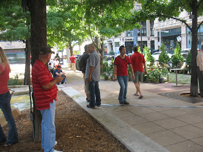
Here, they designed the unauthorized crossing of the tracks out and passengers can only get to the center-platform Las Colinas Urban Center Station at the ends of the platform. Problem is when the bus transfers don't work, as is the case with these riders, there is an added frustration. In this picture, the train is literally behind me, but I knew, and you can tell these guys did too by their lackadaisical walk, that they wouldn't be able to go all the way to the end and then u-turn around and get to the train on time. There were two people ahead who tried and ran. They didn't make it.
Had the design been better, they would have made it. But the divider at the station only stops passengers from crossing easily. Obviously it isn't a problem at Pearl, but I guess in Las Colinas, DART figures the passengers can't handle it.
Also, this raises the question about how DART planners handled the transfers. This was taken on day two of the new line. Shouldn't nearly every transfer meet a train where passengers don't have to wait? Every bus that stops here doesn't meet another transfer point as important as this one. With as many buses and a train line that meet here, this is the part where you coordinate transfer times, and work out from there. Only the TRE station near downtown Irving is near as important. But light rail has a greater frequency and capacity and therefore should get the nod as Irving's most important transit point.

If you squint in the distance, you'll see the name sake of the Irving Convention Center Station, the current terminus of the line.


Surrounding this station is...literally prairie. I guess that means there is a lot of development potential, but virtually no ridership right now.


Here's the sidewalk that leads from the station to...literally nowhere. I guess Irving ran out of bond money when they built their convention center to actually build a sidewalk along Lake Carolyn Parkway.

I take it back, apparently someone or something uses this sidewalk. My two-year old excitedly pointed out two different areas where feces was on the brand new sidewalk.

Here is the northern edge of the station, effectively cordoned off by Northwest Highway. There's somewhat of a controversy. Right now, there is a big parking lot on the other side of the highway that DART used to use as the bus transfer center before moving the buses to the Urban Center Station. They built a tunnel under the highway similar to the U-Dallas Station. However, passengers are complaining it is too long and distant from the station. I didn't see the tunnel when I was there, though I wasn't looking for it. However, that may indicate just how inconvenient that is for passengers (I wasn't looking for the U-Dallas tunnel either, but saw it). Come December, commuters can use the North Lake and Belt Line Stations, which will further reduce this station as a viable one along the new route.

The last picture is just a promise of the line moving on to somewhere else. From here it will veer west and southwest to North Lake Station and eventually on to the airport.
Before I hit the negative, I want to point out what may be the biggest strength of the Orange Line, ironically it is something that could have been done without building a new rail line.
With the opening of the Irving segment, the line now goes all the way to LBJ/Central during all hours, effectively giving that section of the rail system half the headway. Since this is the most ridden part of the DART system, that should help both existing riders and encourage new ones.
Unlike one of my major critiques of the Green Line this one wasn't built in an old freight rail right-of-way. In the past, that meant that the land use really wasn't suitable in most places for an urban rail system. Las Colinas is a bit different. I expect that the Urban Center Station will be the most used when the entire line is complete, partly for this reason. That's also why I wish there were a station near Colorado Dr.
However, similar to the freight critiques, a lot of the line was shoehorned where space was available. The area from east of I-35 to almost Loop 12 is unusable for any type of station. For urban design, the ideal situation is a fewer distance between stations. The Orange Line violates that. However, I can overlook it because there really wasn't a better alternative in the current system to get to Las Colinas, which I believe is important.
My other big concern is that there are many sections on the line where the train just seems to crawl along. It was during one of these stretches where I wondered who added the rapid to DART's name, or which engineer forgot that part when the line was designed.
The last station before the Orange and the Green Line split is Bachman Station. According to this timetable, it takes eight minutes to go from Bachman to U-Dallas Station, another six minutes to get to the Urban Center Station and from there to the Convention Center Station is a manageable three minutes. The distance from Bachman to the end is 4.5 miles. Yet it takes 17 minutes to go the distance. And that's without transfers to get to the final destination. That's an average of a little more than 16 miles an hour. WHAT!!!
16 miles an hour!!! For three stations in 4.5 miles!!!! Much of it grade-seperated!!!!! That has got to be better.
To go from West End Station in downtown Dallas to Irving Convention Center Station requires 36 minutes on the Orange Line. The 202 bus that was replaced by the Orange Line took 31 minutes to go from West End to the North Irving Transit Center. Yes, the Orange Line has to makie stops the express bus didn't, but the Orange Line also doesn't operate in traffic like the bus did.
Sometimes I wonder how much DART actually understands about transit and its system and how much is public relations. In the Metro Section of Tuesday's Dallas Morning News, a story ran about the Orange Line's opening. The authors discuss some riders who say the trip is longer on the train than it was on the bus.
Then comes this from the spokesman:
Morgan Lyons, DART's spokesman, said the train does add time to some commutes. But, he said, there's a logical reason with a potential benefit.
"It simply makes more stops along the way," he said of the many stations between Las Colinas and and downtown Dallas. "It provides new destinations, new access to people."
I don't disagree with the last part as it stands on its own, but it is not the reason it takes longer. It takes longer because the train takes eight minutes to go two miles. Then it takes another six minutes to go less than two miles. That is just unacceptable.
The bridge linking the U-Dallas Station to the rest of the system should be no different than the subway tunnel linking Mockingbird Station with downtown Dallas. Each is their own separate ROW. It is completely grade separated. It shouldn't take even five minutes to run that stretch. But sadly for Orange Line riders, their bridge won't see the 65 mph the trains do in that segment.
Much of the ROW between the U-Dallas Station and the Urban Center Station is within a freeway ROW, and therefore grade-separated. Another two minutes should be taken off from there. I don't mind the slower pace along the Lake Carolyn Parkway section when taken on its own. But added with the creep of the rest of the line, it just feels like a knife twist.
I think the thing that grinds my gears the most is that this wasn't a cheap rail line. With the money spent, we should do better than 16 mph average.
In fact, I could extrapolate that out to say with the amount spent, we should do better than what the Orange Line brings right now.
Before I get into the meat of it, I first want to issue a caution to everyone that this is an incomplete line. 4.5 miles and three stations were added a week ago and another 2+ miles and two stations are set for December. The last phase will see the addition of DFW Airport, which may or may not be the centerpiece of the line or rail network.

Here's the split where the Green Line heads north and the Orange Line turns west.

DART's main hope for ridership growth will be congestion on the freeways where it runs next to and over, in this case I-35E. This is the bridge over the freeway and the trains are amazingly slow for running in their own grade-seperated space.


Las Colinas Urban Station is the best of the three, but that doesn't necessarily mean much. Here, we are looking west to northwest.
I like the treatment given to the tracks of the Lake Carolyn Parkway segment. They used materials similar to the transit mall in downtown Dallas.However, unlike downtown, there is only the one station, so it is less functional than downtown and more about aesthetics.
I wish there were another station or two, but unlike the Las Colinas Boulevard section of the urban center, the Lake Carolyn section is not as developed, so the other parts of the Las Colinas transit mall just aren't cost effective for their own station. That will put more of the onus on the localized transit system, which I will mention briefly in a moment.
I'm not sure that a more developed southern Lake Carolyn Parkway would even make a difference. There are several deferred stations along the Orange Line which DART says will be built if certain conditions are met for ridership goals. One is for a South Las Colinas Station, but it would be outside the Lake Carolyn/Las Colinas circle. For me, bare minimum, a station should go on the Las Colinas transit mall north of Las Colinas Blvd/Colorado Dr.
Las Colinas is one of the few places in DFW outside of the two main cities urban core that has potential to be a good urban neighborhood. The area's transit should reflect that.
Before moving on, take a close look at the right edge of the picture. Note the divider between the station and street. I'll touch on that in a few pictures down.

At the southern edge of the station, a nice park entrance was added that easily takes passengers down to the edge of Lake Carolyn. From here, you can walk the "shoreline" of most of the man-made lake. This connection is a nice little touch.

The view of Las Colinas Station from the edge of the promenade.

Here's one of the more intriguing parts of this station, the connection to the Las Colinas People Mover.


Here's my big problem with this connection. The first pictures shows what should be the passenger entrance to the connection. It even has a gate that leads to a stairway and elevators to the elevated station. But you can't take that, apparently, as it says only authorized people are allowed and points the way passengers should go.
I credited the Parkway's look, with a more streetcar look, rather than the commuter rail look that much of the rail system has. However, as is typical of DART specifically and American systems in general, the tracks are supposed to be off limits to anything but the trains. Look closely at the picture above, aside from the sign that points passengers to cross the street, there is no indication that people should avoid the street-sidewalk-looking tracks. This looks like an extension of the platform. I suspect that many people will walk next to the tracks, after making sure no train is coming of course.
I'm sure there has to be a reason that gate is not for the general public, but I just don't know what it is.

Remember earlier I noted the divider between the station and the street? Here's why. In downtown Dallas, people can easily cross between either side of the station, regardless of whether it is a center-platform station, like Pearl (Arts District) Station or side-platform like St. Paul. It technically is against DART policy to cross the tracks anywhere but at a crosswalk, but it happens all the time, and collisions are low.
Here, they designed the unauthorized crossing of the tracks out and passengers can only get to the center-platform Las Colinas Urban Center Station at the ends of the platform. Problem is when the bus transfers don't work, as is the case with these riders, there is an added frustration. In this picture, the train is literally behind me, but I knew, and you can tell these guys did too by their lackadaisical walk, that they wouldn't be able to go all the way to the end and then u-turn around and get to the train on time. There were two people ahead who tried and ran. They didn't make it.
Had the design been better, they would have made it. But the divider at the station only stops passengers from crossing easily. Obviously it isn't a problem at Pearl, but I guess in Las Colinas, DART figures the passengers can't handle it.
Also, this raises the question about how DART planners handled the transfers. This was taken on day two of the new line. Shouldn't nearly every transfer meet a train where passengers don't have to wait? Every bus that stops here doesn't meet another transfer point as important as this one. With as many buses and a train line that meet here, this is the part where you coordinate transfer times, and work out from there. Only the TRE station near downtown Irving is near as important. But light rail has a greater frequency and capacity and therefore should get the nod as Irving's most important transit point.

If you squint in the distance, you'll see the name sake of the Irving Convention Center Station, the current terminus of the line.


Surrounding this station is...literally prairie. I guess that means there is a lot of development potential, but virtually no ridership right now.


Here's the sidewalk that leads from the station to...literally nowhere. I guess Irving ran out of bond money when they built their convention center to actually build a sidewalk along Lake Carolyn Parkway.

I take it back, apparently someone or something uses this sidewalk. My two-year old excitedly pointed out two different areas where feces was on the brand new sidewalk.

Here is the northern edge of the station, effectively cordoned off by Northwest Highway. There's somewhat of a controversy. Right now, there is a big parking lot on the other side of the highway that DART used to use as the bus transfer center before moving the buses to the Urban Center Station. They built a tunnel under the highway similar to the U-Dallas Station. However, passengers are complaining it is too long and distant from the station. I didn't see the tunnel when I was there, though I wasn't looking for it. However, that may indicate just how inconvenient that is for passengers (I wasn't looking for the U-Dallas tunnel either, but saw it). Come December, commuters can use the North Lake and Belt Line Stations, which will further reduce this station as a viable one along the new route.

The last picture is just a promise of the line moving on to somewhere else. From here it will veer west and southwest to North Lake Station and eventually on to the airport.
Before I hit the negative, I want to point out what may be the biggest strength of the Orange Line, ironically it is something that could have been done without building a new rail line.
With the opening of the Irving segment, the line now goes all the way to LBJ/Central during all hours, effectively giving that section of the rail system half the headway. Since this is the most ridden part of the DART system, that should help both existing riders and encourage new ones.
Unlike one of my major critiques of the Green Line this one wasn't built in an old freight rail right-of-way. In the past, that meant that the land use really wasn't suitable in most places for an urban rail system. Las Colinas is a bit different. I expect that the Urban Center Station will be the most used when the entire line is complete, partly for this reason. That's also why I wish there were a station near Colorado Dr.
However, similar to the freight critiques, a lot of the line was shoehorned where space was available. The area from east of I-35 to almost Loop 12 is unusable for any type of station. For urban design, the ideal situation is a fewer distance between stations. The Orange Line violates that. However, I can overlook it because there really wasn't a better alternative in the current system to get to Las Colinas, which I believe is important.
My other big concern is that there are many sections on the line where the train just seems to crawl along. It was during one of these stretches where I wondered who added the rapid to DART's name, or which engineer forgot that part when the line was designed.
The last station before the Orange and the Green Line split is Bachman Station. According to this timetable, it takes eight minutes to go from Bachman to U-Dallas Station, another six minutes to get to the Urban Center Station and from there to the Convention Center Station is a manageable three minutes. The distance from Bachman to the end is 4.5 miles. Yet it takes 17 minutes to go the distance. And that's without transfers to get to the final destination. That's an average of a little more than 16 miles an hour. WHAT!!!
16 miles an hour!!! For three stations in 4.5 miles!!!! Much of it grade-seperated!!!!! That has got to be better.
To go from West End Station in downtown Dallas to Irving Convention Center Station requires 36 minutes on the Orange Line. The 202 bus that was replaced by the Orange Line took 31 minutes to go from West End to the North Irving Transit Center. Yes, the Orange Line has to makie stops the express bus didn't, but the Orange Line also doesn't operate in traffic like the bus did.
Sometimes I wonder how much DART actually understands about transit and its system and how much is public relations. In the Metro Section of Tuesday's Dallas Morning News, a story ran about the Orange Line's opening. The authors discuss some riders who say the trip is longer on the train than it was on the bus.
Then comes this from the spokesman:
Morgan Lyons, DART's spokesman, said the train does add time to some commutes. But, he said, there's a logical reason with a potential benefit.
"It simply makes more stops along the way," he said of the many stations between Las Colinas and and downtown Dallas. "It provides new destinations, new access to people."
I don't disagree with the last part as it stands on its own, but it is not the reason it takes longer. It takes longer because the train takes eight minutes to go two miles. Then it takes another six minutes to go less than two miles. That is just unacceptable.
The bridge linking the U-Dallas Station to the rest of the system should be no different than the subway tunnel linking Mockingbird Station with downtown Dallas. Each is their own separate ROW. It is completely grade separated. It shouldn't take even five minutes to run that stretch. But sadly for Orange Line riders, their bridge won't see the 65 mph the trains do in that segment.
Much of the ROW between the U-Dallas Station and the Urban Center Station is within a freeway ROW, and therefore grade-separated. Another two minutes should be taken off from there. I don't mind the slower pace along the Lake Carolyn Parkway section when taken on its own. But added with the creep of the rest of the line, it just feels like a knife twist.
I think the thing that grinds my gears the most is that this wasn't a cheap rail line. With the money spent, we should do better than 16 mph average.
In fact, I could extrapolate that out to say with the amount spent, we should do better than what the Orange Line brings right now.
Monday, July 30, 2012
Orange Line and the Airport Connection
The first three stations of the Irving section of the Orange Line opened today and unlike Belo Gardens, I don't need to wait for it to be open a while to discuss it. Sadly, due to family commitments during the Saturday celebration and opening day today, the wait for my critique, which will be similar to that of the Green Line, will have to wait a few more days.
However, prompted by a discussion on Unfair Park, I want to discuss the anticipations of the DFW Airport Station's impact on Orange Line ridership. I want to temper what I think are unrealistic expectations.
The first evidence I want to introduce is from other transit systems.
New York's MTA is a national transit leader, with a total ridership over eight million for its metro system and almost 1 million for its commuter rail network, according to the American Public Transportation Association. Airtrain is a separate line connecting the airport to the metro system. There are two transfer stations connecting this line to the rest of the system, Sutphin Boulevard-Archer Avenue-JFK Airport Station and Howard Beach-JFK Airport Station. The first sees 17,500 daily riders and the second had less than 3,000 daily trips, though the link is from 2009. All told, the roughly 20,000 trips at the airport connection stations (these aren't necessarily airport bound) are only a fraction of a percent of system riders.
Note, that the New York link is to a New York Times multimedia map that shows average daily ridership for every station in the system in 2009. I'm going to make a point later and will use that as a reference point.
Chicago's L carries over 700,000 passenger trips on its heavy rails, and over 300,000 on it commuter system, Metra. The O'Hare Station has about 10,000 rides and the Midway Station sees about 9,000. That's less than two percent of system ridership.
Boston's MBTA, which carries over 500,000 trips on its metro system, almost 250,000 on its light rail system and roughly 130,000 on its commuter rail, sees only 7,000 from its airport connection. That's only .7% of total rail ridership. If we add the Silver Line's airport stop, which is technically an upgraded bus route, round up and don't include its ridership to the system's total, it still only accounts for only 1.1% of the system total.
San Francisco and Oakland's BART system opened an extension to San Francisco International Airport in 2003. Ridership for that four-station segment is 35,000, which includes a connection to the Caltrain commuter line. The station itself sees 5,400 boardings daily. Out of a 380,000 total passenger trips, the airport station accounts for just 1.4 percent of the system.
Even using a system more similar to Dallas doesn't yield any measurable increase in passengers by connecting the system to an airport.
Portland's Max light rail network has as many lines as Dallas, less miles but more stations. The average daily ridership sits right near 125,000. The airport station adds 2,600 to the system, or two percent.
Seattle doesn't publish individual station numbers for its Link light rail system. But the airport station opened in July 2009, with the airport station opening at the end of that year. For the first two quarters, the system didn't have an airport connection and the systems ridership was 14,500 and 18,200. After the airport station opened, ridership for the four quarters of 2010 was 19,500, 24,500, 26,600 and 24,700. Minus a brief up between the first and second quarter, the trend is consistent. As for the "big" increase, it isn't that noticeable compared to a typical station or line opening. Light rail lines will always trend up, even if no new stations are built. Anything around a 50 percent increase would indicate that airport station was different compared to other stations.
There isn't any airport connection in this country that adds a significant amount of riders to the regional rail system. And I am unaware of any system in the world that does, though I would cede I don't know them as well as I do America's.
There are several well established systems that do not have an airport connection. That in-and-of-itself may be proof that airports don't pump up ridership numbers.
So what does? Looking back at that New York map, the higher-ridden stations are those with the greatest density of jobs and residences. As I have said before, for a transit system to be successful, it needs to take people from where they are, to where they want to go in a convenient manner.
Airports and rail systems just aren't that convenient for most people. Passengers, unless they are light packers or on a day trip, just aren't likely to carry luggage from the terminal to the train. Add the fact that two-thirds of DFW Airport's passengers are transferring to another plane, it may not have as many passengers to send to any transportation system, despite the airport consistently being one of the busier airports in the country.
Workers are also unlikely to take the train, because even though there may be a large number of employees within its grounds, it is highly undense and spread out. So unless they work almost directly near the station, they will be highly unlikely to be train commuters.
In fact, I do believe the Orange Line will be the only terminus station that isn't the highest ridden of its own lines outlying stations. That will most likely be Belt Line Station, which isn't far from both the Bush Turnpike and Highway 114. It has all the makings off a highly used commuter station. And similar to what I discussed previously, this is a perfect location for a commuter station.
While these can be useful for the region, airport-to-rail transit doesn't have a huge amount of people using it. Maybe DFW and DART will be different, but I see no reason why it would.
DART is a little more optimistic. In it's Final Environmental Impact Statement for the DFW Station, they predict a daily ridership of 11,200 by 2030, of which 10,500 are airport bound. The others are transfers. I just don't see it. Maybe I am wrong, but I just don't see DART bucking the trend that every other American transit system follows.
Saturday, July 28, 2012
Oil and Water or Parking at Rail Stations
The expanding rail system in Denver is undergoing a fundamental rethink of how it gets it passengers to its rail system as detailed by the Wall Street Journal. There are some very relevant parts for Dallas and DART in there.
Here's the fundamental parts:
After the system opened in 1994, planners built parking lots and garages around many of its stations to cater to commuters. That strategy put parking on land that would have been ideal for stores, apartment buildings and squares catering to riders living adjacent to the stops.
As a result, there has been little of that kind of development around the stations to change the area's car-dependent culture, and riders commute to the stations from up to 20 miles away.
"Once you put in a parking structure, it's difficult to move it," says Bill Sirois, senior planning manager at the Regional Transportation District in Denver.
Denver-transit planners now are becoming more flexible when it comes to how much parking they require near rail stops and where they put it.
In the continuing expansion of the Denver rail system—which will add up to 122 miles of light rail and commuter rail lines to the existing 35 miles within the next 10 years—land adjacent to stations will be earmarked in some cases for village-type developments.
...
Whether to cater primarily to commuters or to residents near rail stops is a pivotal question for mass-transit planners in some cities. Many western cities expanding relatively young rail systems don't have the density or "walkability" that has allowed residents in older, Eastern cities such as New York to eschew cars in favor of mass transit.
Still, some of Denver's peer cities already have embraced this approach. San Francisco's Bay Area Rapid Transit, or BART, and the TriMet mass-transit system in Portland, Ore., long have favored relegating park-and-ride service to their farthest flung stations in the suburbs. Meanwhile, they encourage dense clusters of apartments, condominiums and offices adjacent to their urban rail stops. The twin cities of Minneapolis and St. Paul, Minn., have taken a similar approach recently.
...
Critics ask whether Denver's change in approach on parking will chase some riders away rather than attract them. "So, they're going to make it more difficult to use transit in hopes that the real-estate speculators who use public money to build these things can flourish?" asks Jon Caldara, president of the Independence Institute, a think tank in Denver. A former board member of Denver's transit system, Mr. Caldara long has been among its most vocal critics.
This something I have espoused for a long time. Why would any system that wants to redesign the urban landscape surround the instruments that accomplish that feat with pedestrian-deadening surface parking lots and single-use garages? If the goal is to redo our transportation system from a car-based one to one that sees a greater tendency for walking and transit, why does it virtually require a car for its use?
This, I believe, is a reflection of a different generation. The older planning set, as well as almost all of the political spectrum, see cars as either indispensable or inevitable, neither of which is accurate.
I've said it before and it is relevant here. People will do what is convenient. Americans don't have a love affair with the car. They have a forced marriage. Nothing else is convenient. Look at it in this case, parking lots immediately surrounding stations. Any attempt at redesigning the urban environment around it will be blunted because the parking is taking up the space that the urban environment needs to thrive. We made the car more convenient. So if there is a development there, the impact of seperating the rail station from it with parking will lower the everyday use of the rail system from the development, as well as from people outside the area who might travel to the development.
There are other endless examples of this. A few weeks ago, I talked about how signal timing is a virtual impossibility in an urban area. But what is being timed, whether urban, suburban or rural? Autos, at the expense of everything else. Why aren't the signals timed for bikes? Walking? Buses? All of these have a different speed. By picking the car, we are picking our preference.
What happens when a street is widened? Property is taken to account for that space. What was that property. In an urban area, where most property is flush with the property line, it is sidewalks (in outer areas, it can also be private property). What is the message that is sent when we narrow sidewalks to widen space for cars. The autos have priority over pedestrians.
Speaking of sidewalks, how often do neighborhoods, even close-in ones, have sidewalks? Anything less than 100 percent is too low. Can you imagine a neighborhood without roads? Even rural, farming communities have at least dirt ones. What is that message that is sent that the only infrastructure that was built was to accommodate cars? Cars take priority over anything else.
From 1945-1990, virtually every city large and small built at least one freeway and almost always many more. In the meantime, city transit systems languished. Those that were able to continue were almost always a bus, stuck in traffic (and facing signals not timed for them, slowing them down even more). No new investments were made in transit except in isolated cases. It wasn't until the 1990's that there were multiple cities with concrete additions on the ground.
Reverting back to the topic, it is clear that even when our transit systems were being designed, it was with the idea of the car first. In essence, we are investing in a transportation system not designed to be an alternative to the car, but rather shorten the distance cars make on each trip.
And the ironic part, is exactly what Bill Sirois touched on above. Unless we are talking surface lots, once these parking structures are in place, their stay is quite long, reducing not just the tendency to encourage alternative transportation now, but a long time into the future as well.
What Denver is doing in trying to encourage TOD's, what San Francisco did in allocating parking in the outlying areas is exactly what virtually every rail-building-transit agency should do. Why do the rail stations of Mockingbird, Park Lane, Victory (though the parking is not DART's property), Union (alos not DART's property) Market Center, Inwood, Bachman, 8th & Corinth, Illinois, MLK, Lawnview and White Rock Lake all have abundant parking? There are within five miles of Downtown Dallas, the first place that urbanism started in this area. Several are also near urban enclaves of varying degree. Now granted there are some urban stations, but more have parking than don't, even within Loop 12.
What critics like Jon Caldera fail to realize when they say things like without parking, it won't be used is that at some point, for that dynamic to change, there has to be a starting point. At some point, there will have to be a restriction of parking, there will have to a densification of the urban area.
It isn't because planners dislike cars, but rather out of every widespread transportation system there is, personal autos have the greatest amount of negative externalities, both public (pollution, health, cost, and land) and private (sedentary, cost, injury and death). If we know that, then why are cars put first above everything? It isn't because they are the most efficient or the most operable. New York City and the rest of the Alpha World Class Cities are proof of that. In NYC, walking is the most used transportation form, followed by transit. Cars are third. I'm not saying every city has to be the equivalent, but it would be better than what Dallas achieves, an 87 percent single use occupancy.
For DART, it has to achieve better than 32 stations out of 55 that are commuter-based, or 58 percent. If the the Downtown Dallas rail stations are removed, the percentage is raised to almost two-thirds. The Orange Line opens Monday and I don't know its numbers off the top of my head, though I believe only the Las Colinas Station serves the neighborhood, though the University of Dallas Station may too.
Where are the walkable neighborhoods? Where are the bus transfers? Where is the actual ability to live car-free? All these were promised during DART's referendum to form the agency in the 1980's. While there is a lot that the rail system lacks that is outside DART's control, this is something that could help the system that they have direct control over. In the end, they have to ask themselves do they want a transit system that serves the future of Dallas, or one that was built for the 1980's Dallas.
Thursday, July 26, 2012
Are Kids the Urban Canary in the Coal Mine?
I have touched on the idea of kids, cities and suburbs are few times, and shall revisit that here, thanks to an article I read in the Salon, written by Will Doig.
In the past, I have said that urban design can make it dangerous for kids to walk on their own. This article looks at the issue from a different approach. In essence, by not allowing kids to walk, we are suppressing urban life, something that is essential to a vibrant streetscape.
Exactly right. When suburbs are all you know, and when you have a city like Dallas that tries to emulate suburban design, it is no wonder the current generation doesn't know anything but the suburbs.
I'd even take it a step further. Yes the physical activity is important, but what does this do for kid's mental development? What happens when a teen finally has freedom they never had before? What happens when a helicopter parent stays in their kids life and directs their children, even when they are in college and beyond?
It is a fact that the human brain develops most of its lifelong functions before ten. If kids don't know how to handle freedom and responsibility before that process finishes, then they will struggle with it for the rest of their lives.
This is what gets at the heart of the matter for me. This is the oxymoron of suburban development. We want to make our kids safer, yet the thing that makes that perceived safety possible, is actually the biggest threat of all. The number one killer of humans between the age of 2 and 19 is the car. Nothing kills our kids more, not disease, not inner city violence, not bullying and certainly not walking outside but ferrying our kids around in the car. But we never hear of the dangers of that, at least not on any large scale. But we do hear about the more rarer incidents like abductions, and then paradoxically, we keep them more isolated and more dependent upon the car.
And in the end, Salon notes, when we think of kids in the design of our cities, everyone wins.
I shudder to think of what cost suburbanization will have on the baby boomers. Once their capacity to drive has diminished to the point of dangerous for themselves and society, it is either nursing home or extreme isolation. Neither sounds pleasant. Cities with a greater degree of walkability will certainly have the edge, both for their citizens personal benefits and socially as a whole.
In the past, I have said that urban design can make it dangerous for kids to walk on their own. This article looks at the issue from a different approach. In essence, by not allowing kids to walk, we are suppressing urban life, something that is essential to a vibrant streetscape.
That a kindergartner was allowed to toddle four blocks without adult
supervision seems extraordinary now, even though cities are at least as
safe for children today as they were then. Crime is at a 40-year low.
The percentage of kids fatally hit by cars has been dropping for
decades. And the child abductors that leer from every corner are tabloid
fantasy — only about 100 kids, out of tens of millions, are kidnapped in public by a stranger each year.
So
naturally, children can now be found romping unsupervised throughout
our neighborhoods, acquiring the intuition, resourcefulness and sense of
independence that such a childhood provides, right?
Actually, no.
In the time since [Lenore] Skenazy walked off to kindergarten alone, the number
of children that can be found in public without supervision has only
diminished. In one survey, 85 percent of mothers said they allowed their
kids outside unsupervised less frequently than they themselves were allowed. In Britain, the average age of children allowed to play outside adult-free has risen by more than a year since the ’70s, and 25 percent of 8- to 10-year-olds have never played outside without an adult. One study diagrammed
the shrinking distances that four generations of one family’s kids were
allowed to stray from home: six miles in 1919, one mile in 1950, half a
mile in 1979, and 300 yards today.
I think this is what it boils down to when parents think about this. We all want our kids to be safe. Yet, we always revert to the lowest common denominator. When they are infants, we have baby monitors or video feeds to make sure they are safe when they move to their on room, away from parental supervision. Play dates weren't "invented" 20 years ago, because we just naturally let our kids go out and play...by themselves or to their friends. Even things that I can remember doing as a kid (I am just 32) aren't allowed anymore by lots of parents. I remember the first freedom I felt when I got my own bike and was allowed to roam the neighborhood alone or with friends or sister. My parents said what to watch out for and what to do and let me be on my way. And you know what? I did it. I believe to often we think kids don't have the ability to follow instructions when it matters, but they do. We did.
I think that may be more of the crux of this issue. Trust. Either we don't trust our kids or don't trust other people.
That also comes into part of what good urban areas build, a community trust. Seeing the same people, eventually socializing with them builds social capital. When you see the same folks, an informal relationship builds. Even seeing the same type of people tears down walls. In an area that is car-oriented, those things aren't possible. People aren't out socializing, they are in their own private sphere. People there just aren't able to do the same things in suburbs that they can in quality urban areas.
My son, in a few years, will be able to walk to the convenience store a block away. Folks in the suburbs can't, because it is a mile or more and the streets may or may not have sidewalks, but a certainly border thoroughfares that are a minimum of six lanes, straight and at least 40 miles per hour and usually more.
However, until now, I never thought of the urban area's health and vitality in terms of children walkability.
She travels the globe preaching the gospel of less-protective
parenting and hosts an annual event called “Take Our Children to the
Park and Leave Them There,” which is exactly what it sounds like. It’s
not just for the kids’ sake: Skenazy believes that free-roaming children
are an integral part of what makes a good city. “When you’re talking
child-friendly, you’re usually talking about the same things urban
planners talk about: mixed-use, people outside, a rhythm to the
streets.”
She says the “Popsicle test” is a convenient way to use
free-roaming kids to gauge a city’s health. “If an 8-year-old child can
go get a Popsicle from the store by themselves and finish it before they
get home, that city is probably thriving,” says Skenazy. Such an act is
possible only in a walkable, reasonably safe environment that has a
good pedestrian infrastructure and where retail and residences are
relatively intermixed.
As it happens, this is exactly the type of environment that’s
proliferating in many cities. So why has kids’ freedom to roam only
faltered? Overprotective parenting is, of course, the culprit that first
springs to mind. “We’ve come around to the idea that parenting is a
skill,” says psychologist Alex Russell.
“We’re now all aware that those early years are extremely formative.”
But another reason, says Russell, “is that we are parenting more and
more in isolation. Parents used to parent in communities, but now it
falls squarely on the mother and father.”
This, I think, is a direct result of suburbanization. This village parenting idea has existed for centuries and more. The phrase it takes a village is quite old, but no longer applies to our country's society. Low-density, car-oriented design has spread families apart and isolated us from our neighbors. Add in the mistrust that isolation brings and it is no wonder kids aren't allowed to be kids.
Cities reinforce this paradigm with ever more creative ways of banning
unsupervised kids, even though the definition of “unsupervised” depends
on one’s perspective. As Russell suggests, kids can be supervised in the
absence of their parents. In the Sydney Morning Herald, a writer
recently marveled
at seeing children wandering unchaperoned all over Tokyo. When she
worried to her Japanese colleague about the lack of adult supervision,
he responded, “What do you mean, no adults? There were the car drivers,
the shopkeepers, the other pedestrians.” In Japan, 80 percent of kids
between 6 and 12 walk to school grownup-free.
I have always marveled at the Japanese urban design. Now there are obvious cultural differences, but they build cities in the way that I preach here. There is a great appreciation for social bonds and responsibilities there.
In some ways, I don't think it is that much different here, only the design. Here's what I mean. If I am walking down the street and I see a kid, I watch the kid, even if only casually. If something bad were to happen, like an abduction, theft or just a crying kid, I intervene. Surely, there isn't that many who wouldn't. Yet here, we first think the parents are bad.
And it also takes a step for the parent too. In my personal experience, it can be hard to give them that freedom that isn't 100% secure or safe. But I see an independence streak in him that I had. And I am already seeing the parental and developmental benefits of giving him freedom to make choices.
Part of this is simple geography — Americans are more spread out than
the Japanese. Sixty percent of Americans lived within two miles of their
children’s schools in 1969. Now, 40 percent do. This helps explain why,
in 1969, walking or biking was the most common way of getting to school, according to a UCLA study. Today, only about 13 percent of kids get to school that way.
BTW, we also had a childhood obesity epidemic. Coincidence? Certainly not in part. A lot of blame goes to video games or staying indoors, but now allowing them to walk for everyday needs may be the biggest change that requires the smallest change.
Also, if people say kids don't get enough outdoor play time, but they aren't allowed to go outside on their own, is it a shock they aren't getting enough active play time?
Once again, I think suburbanization plays a part. Some people have expressed their opinions that I am making a bad decision by not moving to a single-family house with a backyard. I just don't think that is necessary. When you realize that humans survived centuries upon centuries without backyards, it does seem weird that a relatively recent invention is considered an absolute necessity for childhood development.
“It’s almost a suburbanization of cities,” says Skenazy. “The idea that
we should keep kids in cars and hover at the park and be with them 24/7 —
it started in the suburbs and became the norm for parenting.”
Exactly right. When suburbs are all you know, and when you have a city like Dallas that tries to emulate suburban design, it is no wonder the current generation doesn't know anything but the suburbs.
[Nancy] Pullen-Seufert gets this, and I imagine that when she’s not talking to a
reporter, she’s just as openly frustrated with parents’ irrational
fears as Lenore Skenazy is. “Sometimes what we hear from [parents] is,
‘Look, my job is to protect my kid, and if this is one less thing I can
expose them to, great, let’s mark it off the list,’” she says. “For a
while some organizations tried to convince parents by saying, ‘Take the
longer-range look: This is a way to build physical activity into your
kid’s day.’ And some parents bought that, but a lot of others just said
they could get the physical activity in other ways.”
I'd even take it a step further. Yes the physical activity is important, but what does this do for kid's mental development? What happens when a teen finally has freedom they never had before? What happens when a helicopter parent stays in their kids life and directs their children, even when they are in college and beyond?
It is a fact that the human brain develops most of its lifelong functions before ten. If kids don't know how to handle freedom and responsibility before that process finishes, then they will struggle with it for the rest of their lives.
It says something that we perceive walking down the street to be a
greater risk to kids than speeding along in two tons of steel and glass,
when in actuality, four-fifths of kids killed by cars are in those
cars. No parent, however, is going to be accused of endangering their
child by driving them to school, but the parent who lets them walk might
be — the fear of being judged by other parents looms large. As does the
fear of liability on the part of these schools and cities. “Our belief
in our communities has been eroded by fears of lawsuits, insurance
companies whaling on the schools, the constant din of horror story tonight at 6,” says Skenazy.
This is what gets at the heart of the matter for me. This is the oxymoron of suburban development. We want to make our kids safer, yet the thing that makes that perceived safety possible, is actually the biggest threat of all. The number one killer of humans between the age of 2 and 19 is the car. Nothing kills our kids more, not disease, not inner city violence, not bullying and certainly not walking outside but ferrying our kids around in the car. But we never hear of the dangers of that, at least not on any large scale. But we do hear about the more rarer incidents like abductions, and then paradoxically, we keep them more isolated and more dependent upon the car.
And in the end, Salon notes, when we think of kids in the design of our cities, everyone wins.
And seeing kids outside can give people confidence in their city, too.
It can make them think twice about speeding in their cars and help old
people age in place (kid- and senior-friendly infrastructures are often
one and the same). “There’s this intangible piece to it,” says
Pullen-Seufert, when asked what makes a true safe route for a child.
“It’s an overall community feel, where people just feel comfortable
being out there.”
I shudder to think of what cost suburbanization will have on the baby boomers. Once their capacity to drive has diminished to the point of dangerous for themselves and society, it is either nursing home or extreme isolation. Neither sounds pleasant. Cities with a greater degree of walkability will certainly have the edge, both for their citizens personal benefits and socially as a whole.
Subscribe to:
Posts (Atom)