Short answer no, but listening to the Economic Development Committee this week might have given someone who reads this blog a different impression.
I have mentioned the urban design flaws of Victory Park before. One of the items before the EDC this week was the latest proposal by the owners of Victory Park to turn it around. I won't go into details since I only know the generics, turn Olive into a more pedestrian-friendly street, widen sidewalks all over and get rid of some one-way streets in favor of two-way. Sounds good, but without concrete proposals or blueprints, I just can't comment with certainty. Victory Park in its generic form sounded good, but the devil was in the details.
But I offer these quotes from Griggs.
"If you want these water-colors (artist renderings) to be a reality, you have to stop focusing on the events and focus on everyday life."
"You can't have events drive the every day. We want to build a
successful community in an urban environment and to do that you need
life between buildings on a day in, day out basis."
Victory Park is "one of the biggest failures of urban design ever imaginable."
No link to the Katy Trail "is going to be a regrettable mistake."
Griggs also noted the poor relation to Victory Park and the DART light rail station.
He wasn't the only one with attention directed towards the flaws. I think we are finally getting council members who get urban areas.
Adam Medrano questioned city staffers on why bike lanes were absent in the redo plans. His council district covers the area.
Lee Kleinman, similar to Griggs, noted there is a lack of everyday needs for the area. He also made mention that arena-anchored areas tend to fail, something I have said many times, particularly on the economic development front.
It is really refreshing to see Council members ask the hard questions and point out the obvious, rather than take the developers word and hope for the best.
Showing posts with label urban. Show all posts
Showing posts with label urban. Show all posts
Friday, October 11, 2013


Sunday, July 21, 2013
Belo Garden. I promised it and as a man of my word (eventually) I will give forth.
Belo Garden is the second on four major parks planned for the downtown area. It opened in May 2012 to great fanfare. Paired with Main Street Garden, Belo bookended the Main Street District, the heart of urban Dallas. The idea was to extend the activity of the Main Street District out, provide urban greenspace and encourage redevelopment around the parks.
While Main Street Garden was designed to be a programmed park, chock full of activity possibilities and special events, Belo was intentionally designed to be passive and reflective. In many ways, they achieved their goal, and that is where a big problem with the park stems from. Downtown is not lacking of this.

In this Google maps above, aside from Pegasus Plaza, Main Street Garden and Klyde Warren Park (not pictured), all these parks have two common features: they were designed to be passive. Consequently, they have very few visitors.
One reason I waited to post until many months after its opening was I want to see how the space operates on a day-to-day basis. I had my suspicions but wanted to see in real time. Sadly with Belo, I wasn't wrong. Except for a few dog walkers, this park is empty most of the time. That is partly by design. A passive park that offers little activity possibilities will do this.
The most active portion of the park is a water feature that gets moderate use during the weekend mornings in summer and the Pegasus Charter School kids spend some afternoons here. It isn't uncommon to see kids running through and enjoying themselves. But otherwise, an empty, but pretty, Belo Garden is the norm.
The other part of the park where activity is possible is the tables and chairs on a course dirt surface on the east end of Belo Garden. Designed as a picnic area, it succeeds in drawing some folks here. But as is often the case, the powers that be think many who are using it don't belong. This friction that exists between the homeless and downtown Dallas is evident here as well. Add in the fact that many folks already have a negative perception of the homeless, regardless whether they are actually doing something negative or not, and is another point of contention for the park.
I don't like that this animosity exists, but Dallas is a much more pretentious city than many of the true urban areas in the country. There exists a perception that Dallas' homeless population is also a bigger nuisance than these other cities and it has all the ingredients for a recipe in conflict.
Unlike the grassy section in Main Street Garden, all the grassy areas in Belo are tree covered. While shade is almost a universally a good idea in public spaces in Dallas, in Belo Garden, it makes the space useless for anyone who isn't dog walking. Picnicking would be a possibility, but in summer, the ammonia smell can be overwhelming in parts of Belo. The trees are too young for hide and seek, too thin to climb, too clustered for throwing or kicking a ball and there are no benches in the immediate vicinity to enjoy the shade.
Halfway down the park on the Main Street side is a hill. The main point of the hill is too minimize traffic noise. That is an admirable quality. The issue I have is the hill is so small compared to the rest of the park that it doesn't really do the job. Add in the fact that the higher volume of cars as well as the faster ones are located on Commerce Street and it is little more than a way to vary the terrain of the park.
A true noise reducer, as well as pedestrian-comfort amenity, would have been to allow on-street parking on either side of the park along Main AND Commerce. Main is already a street with slower speeds. Coupled with the setback of One Main Place, the primary noise and echo effect are not the greatest from Main. It is Commerce, with its higher speeds, higher vehicle count and the Earle Cabell echo that really causes the noise. No hill or metered street parking on Commerce mean that noise hasn't been reduced by the hill.
Ultimately, it was this aspect that delayed my post on Belo Garden for so long. I kept hoping for something, like a different city department that was just late in the installation (or really re-installation, since both Main and Commerce had parking meters prior to Belo construction) of the meters and this wasn't overlooked. I rationalized they were on their way, since Main Street Garden was careful to include them in its design. Since the bike markers occupy the middle lanes of Main Street before arriving at Belo and after leaving the park, it then became obvious, with them on the edge of the street here that on-street parking is out. Sigh.
I don't like this for several reasons. When I get to the bike lanes in downtown, I will say that switching lanes, which is what is happening on this stretch of Main, raises the risk for accidents. In this case, it also guarantees no on-street parking, one of the few things that benefit both car users and walkers.
At least on Main Street, there is enough other urban activity and amenities going for it that it still has the feel of an urban street. Commerce Street is much less so and really could have benefited from the presence of on-street parking.
One of the biggest controversies during the planning phase of Belo Garden came between the park organizers and the Metropolitan condos, which are adjacent to the park within the same block. The Belo foundation didn't want a driveway, which borders the west side of the condo tower, to be directly adjacent to the park. Their solution was a wall, which the building then opposed.
This is one of the few times where I see both sides and can agree with both too. On the one hand, I understand the condo owners wouldn't like the front view of their lobby to be a wall, when it could be greenspace. I also understand they wouldn't like to have to walk to the edge of the property to go around and enter the park. I also see why the Belo Foundation wouldn't want their intentionally-designed "peaceful" park to be next to a driveway.
The sad thing is, both violate good urban design practices, which is why I really didn't take one side or the other. An urban building shouldn't need a driveway, especially when the property has to garage entrances on the north and south side. Why does there need to be a driveway on the west? From the park's perspective, building a wall, by definition divides things. Good urban areas are seamless and transition well from one to the other. In the case of this park, well, there clearly is an end point. Since neither side presented a good urban solution, I just didn't care, and ultimately, it is downtown that suffers.
One of the main positives talking points of the park by the way it was designed is also a negative. The designers intentionally used native, drought-resistant grasses, which is a really good thing, but the placement segments the park. They are tall and dense enough to tell users don't pass through here (besides, there may be a present from a four-legged friend in here). And on top of it, they built it on the edges too and it segregates the park from the sidewalk, a major urban violation.
At the very least, Belo has an intangible that no other park in downtown has, something of comedic value. I'll let the sign speak for itself.

I hate that I sound overly negative...again. But Dallas talks a good game about making downtown urban, or rather returning to its urban roots. But then produces what they have been doing for the last 50 years, which turned it from an urban area into an office park. Main Street Gardens is a good urban park, though it has flaws, its urban design, things like on-street parking, sidewalk width, pedestrian amenities, integration of sidewalk to park, etc., are really solid.
Belo is not. The design separates the park from the sidewalk, isolates the pedestrian and offers the pedestrian little urban activity. Yes, it is better than the parking lot that was there, but downtown Dallas, especially in the Main Street core, doesn't need incremental improvement. It needs to, if not a home run, at least get an extra base hit every time. Belo is a walk.
Belo Garden is the second on four major parks planned for the downtown area. It opened in May 2012 to great fanfare. Paired with Main Street Garden, Belo bookended the Main Street District, the heart of urban Dallas. The idea was to extend the activity of the Main Street District out, provide urban greenspace and encourage redevelopment around the parks.
While Main Street Garden was designed to be a programmed park, chock full of activity possibilities and special events, Belo was intentionally designed to be passive and reflective. In many ways, they achieved their goal, and that is where a big problem with the park stems from. Downtown is not lacking of this.

In this Google maps above, aside from Pegasus Plaza, Main Street Garden and Klyde Warren Park (not pictured), all these parks have two common features: they were designed to be passive. Consequently, they have very few visitors.
One reason I waited to post until many months after its opening was I want to see how the space operates on a day-to-day basis. I had my suspicions but wanted to see in real time. Sadly with Belo, I wasn't wrong. Except for a few dog walkers, this park is empty most of the time. That is partly by design. A passive park that offers little activity possibilities will do this.
The most active portion of the park is a water feature that gets moderate use during the weekend mornings in summer and the Pegasus Charter School kids spend some afternoons here. It isn't uncommon to see kids running through and enjoying themselves. But otherwise, an empty, but pretty, Belo Garden is the norm.
 |
| The main active feature of Belo Gardens. |
The other part of the park where activity is possible is the tables and chairs on a course dirt surface on the east end of Belo Garden. Designed as a picnic area, it succeeds in drawing some folks here. But as is often the case, the powers that be think many who are using it don't belong. This friction that exists between the homeless and downtown Dallas is evident here as well. Add in the fact that many folks already have a negative perception of the homeless, regardless whether they are actually doing something negative or not, and is another point of contention for the park.
I don't like that this animosity exists, but Dallas is a much more pretentious city than many of the true urban areas in the country. There exists a perception that Dallas' homeless population is also a bigger nuisance than these other cities and it has all the ingredients for a recipe in conflict.
Unlike the grassy section in Main Street Garden, all the grassy areas in Belo are tree covered. While shade is almost a universally a good idea in public spaces in Dallas, in Belo Garden, it makes the space useless for anyone who isn't dog walking. Picnicking would be a possibility, but in summer, the ammonia smell can be overwhelming in parts of Belo. The trees are too young for hide and seek, too thin to climb, too clustered for throwing or kicking a ball and there are no benches in the immediate vicinity to enjoy the shade.
 |
| Note the one bench you see in this picture is not near a shade-providing tree. |
 |
| All grassy areas are similar to these. |
 |
| This hill is better as a park feature than noise reducer. |
A true noise reducer, as well as pedestrian-comfort amenity, would have been to allow on-street parking on either side of the park along Main AND Commerce. Main is already a street with slower speeds. Coupled with the setback of One Main Place, the primary noise and echo effect are not the greatest from Main. It is Commerce, with its higher speeds, higher vehicle count and the Earle Cabell echo that really causes the noise. No hill or metered street parking on Commerce mean that noise hasn't been reduced by the hill.
 |
| The bike marker and no parking sign are the final pieces of evidence that on-street parking was nixed. The noise-reducing hill is on the right. |
I don't like this for several reasons. When I get to the bike lanes in downtown, I will say that switching lanes, which is what is happening on this stretch of Main, raises the risk for accidents. In this case, it also guarantees no on-street parking, one of the few things that benefit both car users and walkers.
At least on Main Street, there is enough other urban activity and amenities going for it that it still has the feel of an urban street. Commerce Street is much less so and really could have benefited from the presence of on-street parking.
 |
| Straight, narrow and fast, a bad combo for pedestrians. This Commerce Street view illustrates the lack of cover for anyone walking next to this speedway. |
One of the biggest controversies during the planning phase of Belo Garden came between the park organizers and the Metropolitan condos, which are adjacent to the park within the same block. The Belo foundation didn't want a driveway, which borders the west side of the condo tower, to be directly adjacent to the park. Their solution was a wall, which the building then opposed.
 |
| The wall between the park and neighboring condos. |
The sad thing is, both violate good urban design practices, which is why I really didn't take one side or the other. An urban building shouldn't need a driveway, especially when the property has to garage entrances on the north and south side. Why does there need to be a driveway on the west? From the park's perspective, building a wall, by definition divides things. Good urban areas are seamless and transition well from one to the other. In the case of this park, well, there clearly is an end point. Since neither side presented a good urban solution, I just didn't care, and ultimately, it is downtown that suffers.
One of the main positives talking points of the park by the way it was designed is also a negative. The designers intentionally used native, drought-resistant grasses, which is a really good thing, but the placement segments the park. They are tall and dense enough to tell users don't pass through here (besides, there may be a present from a four-legged friend in here). And on top of it, they built it on the edges too and it segregates the park from the sidewalk, a major urban violation.
 |
| Here, the grasses separate the picnic area from the rest of Belo. It happens in way too much of the park. |

I hate that I sound overly negative...again. But Dallas talks a good game about making downtown urban, or rather returning to its urban roots. But then produces what they have been doing for the last 50 years, which turned it from an urban area into an office park. Main Street Gardens is a good urban park, though it has flaws, its urban design, things like on-street parking, sidewalk width, pedestrian amenities, integration of sidewalk to park, etc., are really solid.
Belo is not. The design separates the park from the sidewalk, isolates the pedestrian and offers the pedestrian little urban activity. Yes, it is better than the parking lot that was there, but downtown Dallas, especially in the Main Street core, doesn't need incremental improvement. It needs to, if not a home run, at least get an extra base hit every time. Belo is a walk.
Tuesday, June 18, 2013
The Physical Importance of Walking
Planners, urbanists and those who advocate for walkable neighborhoods have done a really good job of giving overarching reasons why we need to increase the amount of walkable neighborhoods in our cities. One of the more obvious reasons why we need to increase them is health.
While it seems obvious, more walkability means more healthy citizens, where they haven't done a good job is getting into the whys, though it is beyond the scope of what they do. So I wanted to get into some detail on that, just why more walking is better for everyone.
Our bodies receive fuel from two sources, fat and carbohydrates. At its basic, the body converts fat into the energy it needs to operate. As I sit here and type this, as you sit here and read this, our bodies are burning fat, just to stay alive, as well as the small amounts of energy required to carry out those duties. Now, not very much fat is burned, so you can't claim to be working out by sitting.
The thing about fat is that it requires a lot of oxygen to convert to energy. That's why as we sit here, we breathe. It is also why as we exert ourselves more, we breathe faster and heavier.
It is at this point that our body switches to the second energy source. Carbs are a short-term energy source that do not require near as much oxygen to convert to energy. They are also not stored in any large quantities. If you have ever seen a bike race, the most popular being the Tour de France, they are constantly eating. The reason is to keep the carbs supply high enough to operate efficiently.
We most associate physical activity and muscle use with increased breathing, but it can be other parts of the body. If a person is sitting out in the mid-August sun with no shade, their body may switch to carbs to operate the cooling system because it is having to work a lot harder and also keep the vital organs going. At that point, they will start to breath faster, even though they aren't moving.
Unlike carbs, fat is able to be stored in very large quantities, in some cases beyond a reasonable health level. But the average person doesn't need large amounts of carbs, so the human body developed a system to store the energy we need. At some point, the body will convert carbs to fat and store the energy for future use.
Now the point at which the body begins the switching to carbs varies, but generally speaking, the better physical shape a person is in, the longer it takes. In other words, a person in good shape can run longer before the body switches. It is also important to note that just because you start to breath faster, doesn't mean the body has started the switch. It just means it needs more oxygen right now. Someone who is huffing and puffing is virtually guaranteed to be burning carbs, but one who is at a slightly elevated breathing level is likely to still be burning fat, just more of it than normal.
This is where walking comes in. The average person burns between 50 to 100 calories if they walk for 10 minutes and most people minus the exceptionally out-of-shape would burn fat to fuel that walk. If we lived in more walkable areas, going to run minor errands would not only accomplish the task, but burn fat, since that is likely the fuel source used at low levels of exertion.
An extra ten minutes of walking a day, taken out over the course of a year, using a conservative 65 calories per walk, would burn a total of 23,725 calories. One pound of fat equals 3,500 calories, so walking an extra ten minutes a day would equate to a loss of almost seven pounds a year.
Now imagine if that came out of doing day-to-day things, instead of having to find the time to walk. Replacing neighborhoods that require a car with one where it is one of many options has a huge health benefit. Just living in a more walkable neighborhood, and changing a lifestyle to match the neighborhood, would slim the waistline tremendously.
While it seems obvious, more walkability means more healthy citizens, where they haven't done a good job is getting into the whys, though it is beyond the scope of what they do. So I wanted to get into some detail on that, just why more walking is better for everyone.
Our bodies receive fuel from two sources, fat and carbohydrates. At its basic, the body converts fat into the energy it needs to operate. As I sit here and type this, as you sit here and read this, our bodies are burning fat, just to stay alive, as well as the small amounts of energy required to carry out those duties. Now, not very much fat is burned, so you can't claim to be working out by sitting.
The thing about fat is that it requires a lot of oxygen to convert to energy. That's why as we sit here, we breathe. It is also why as we exert ourselves more, we breathe faster and heavier.
It is at this point that our body switches to the second energy source. Carbs are a short-term energy source that do not require near as much oxygen to convert to energy. They are also not stored in any large quantities. If you have ever seen a bike race, the most popular being the Tour de France, they are constantly eating. The reason is to keep the carbs supply high enough to operate efficiently.
We most associate physical activity and muscle use with increased breathing, but it can be other parts of the body. If a person is sitting out in the mid-August sun with no shade, their body may switch to carbs to operate the cooling system because it is having to work a lot harder and also keep the vital organs going. At that point, they will start to breath faster, even though they aren't moving.
Unlike carbs, fat is able to be stored in very large quantities, in some cases beyond a reasonable health level. But the average person doesn't need large amounts of carbs, so the human body developed a system to store the energy we need. At some point, the body will convert carbs to fat and store the energy for future use.
Now the point at which the body begins the switching to carbs varies, but generally speaking, the better physical shape a person is in, the longer it takes. In other words, a person in good shape can run longer before the body switches. It is also important to note that just because you start to breath faster, doesn't mean the body has started the switch. It just means it needs more oxygen right now. Someone who is huffing and puffing is virtually guaranteed to be burning carbs, but one who is at a slightly elevated breathing level is likely to still be burning fat, just more of it than normal.
This is where walking comes in. The average person burns between 50 to 100 calories if they walk for 10 minutes and most people minus the exceptionally out-of-shape would burn fat to fuel that walk. If we lived in more walkable areas, going to run minor errands would not only accomplish the task, but burn fat, since that is likely the fuel source used at low levels of exertion.
An extra ten minutes of walking a day, taken out over the course of a year, using a conservative 65 calories per walk, would burn a total of 23,725 calories. One pound of fat equals 3,500 calories, so walking an extra ten minutes a day would equate to a loss of almost seven pounds a year.
Now imagine if that came out of doing day-to-day things, instead of having to find the time to walk. Replacing neighborhoods that require a car with one where it is one of many options has a huge health benefit. Just living in a more walkable neighborhood, and changing a lifestyle to match the neighborhood, would slim the waistline tremendously.
Sunday, July 15, 2012
Retail Targets for Downtown Dallas
There is a prevalent idea around these parts about just what kind of retail needs to exist in the urban core. The basic premise is that Downtown Dallas can't compete with the suburbs on a one-to-one basis. So, in order to attract customers, the retail and restaurant offerings have to be unique, and not available anywhere else in the region.
This line of thinking makes a lot of sense and I don't disagree with it entirely. The thinking is that someone won't pass by three Gap's to get to one located Downtown. However, I do believe this is an overly simplistic, and in some cases archaic, view.
First, this assumes that everyone lives far away from Downtown. As more and more people live in the urban core, this is less and less and issue. People who live in the core have similar desires and consumption habits as their affluent suburban counterparts.
The idea of only destination retail Downtown also suffers from a lack of context when it comes to urban design. Classic urban design areas have withstood the test of time, literally many millennia. Meanwhile, the typical shopping mall and strip center have a lifespan of only several decades. On top of that, preferences for building and patronizing these places has fallen over the years, in favor of...more urban style developments. So for some folks, they'd rather drive past all the other Old Navy's or Olive Garden's. So, if from that angle, is it reasonable to assume that "average" retail offerings would be appealing in Downtown?
An obvious flaw with destination retail is the price point. Urban areas are supposed to be all-inclusive. If the retail and restaurant products require a hefty penny, that excludes all lower-class folks and most middle-class people as well. If what we are encouraging actually encourages people to not patronize the area, reducing its vibrancy, isn't that fundamentally backwards?
This is one of the main reasons, especially outside of the urban design, that Victory struggled.
One of the biggest impediments, once again excluding current urban design, is the transportation system. There are three conflicting issues that make Downtown Dallas inconvenient.
1) The city's urban core was built prior to the automobile. This meant the urban area was based around walking and then transit (specifically the streetcar). Even after the automobile was introduced and into the first couple of decades of the 20th century, the design stayed steady. Therefore, most everything within a three mile radius of downtown is still based on this mode.
2) In an effort to modernize Downtown for the car, planners and traffic engineers shoehorned in a freeway system with wide roads to facilitate travel to the freeways, decimating parts of the urban environment. However, these additions did not make Downtown auto-friendly, further complicating the local transportation system. It is no longer as transit-friendly, the auto additions alienated the pedestrian and Downtown is still not as car-friendly as the suburbs, which were built with cars as the priority.
3) The transportation system helped foster in a transition from mixed-use to office park. This saw large scale evacuation of a varied retail landscape in Downtown.
So, as it stands right now, Downtown is inconvenient to drive to, taking transit is inconsistent and walking came be uncomfortable. Tell me why any business would locate here?
I initially started pondering this idea when I thought of just how many unique places that were opened in redeveloped buildings had closed: a wine-crafter in the Davis Building, several versions of a club in the old bank vault within the Davis, a furniture store in the Davis, a knick-knack shop in the Kirby, a clothier in DP&L, and numerous restaurants not found anywhere else. So if the thought is we can't do more common retail and unique retail can't stay open, what are we to do? The answer in just a moment.
But first, I don't want this to come off like I am pro-chain and anti-local, though in a region as large as this those labels aren't so concise. Some of my family's most common destinations are local. However, there are large amounts of people who don't prefer something that they don't know.
I think the answer, then, has to be that Downtown include some of everything, especially if we as a city can remedy the transit problem. If more of the retail locates along the transit mall in downtown, it becomes really convenient.
Think back to our modern shopping areas. There is usually a mix of destination and common retail. Downtown Dallas was the original outdoor shopping mall. If we can reintroduce that proper mix of retail, I believe can be again.
This line of thinking makes a lot of sense and I don't disagree with it entirely. The thinking is that someone won't pass by three Gap's to get to one located Downtown. However, I do believe this is an overly simplistic, and in some cases archaic, view.
First, this assumes that everyone lives far away from Downtown. As more and more people live in the urban core, this is less and less and issue. People who live in the core have similar desires and consumption habits as their affluent suburban counterparts.
The idea of only destination retail Downtown also suffers from a lack of context when it comes to urban design. Classic urban design areas have withstood the test of time, literally many millennia. Meanwhile, the typical shopping mall and strip center have a lifespan of only several decades. On top of that, preferences for building and patronizing these places has fallen over the years, in favor of...more urban style developments. So for some folks, they'd rather drive past all the other Old Navy's or Olive Garden's. So, if from that angle, is it reasonable to assume that "average" retail offerings would be appealing in Downtown?
An obvious flaw with destination retail is the price point. Urban areas are supposed to be all-inclusive. If the retail and restaurant products require a hefty penny, that excludes all lower-class folks and most middle-class people as well. If what we are encouraging actually encourages people to not patronize the area, reducing its vibrancy, isn't that fundamentally backwards?
This is one of the main reasons, especially outside of the urban design, that Victory struggled.
One of the biggest impediments, once again excluding current urban design, is the transportation system. There are three conflicting issues that make Downtown Dallas inconvenient.
1) The city's urban core was built prior to the automobile. This meant the urban area was based around walking and then transit (specifically the streetcar). Even after the automobile was introduced and into the first couple of decades of the 20th century, the design stayed steady. Therefore, most everything within a three mile radius of downtown is still based on this mode.
2) In an effort to modernize Downtown for the car, planners and traffic engineers shoehorned in a freeway system with wide roads to facilitate travel to the freeways, decimating parts of the urban environment. However, these additions did not make Downtown auto-friendly, further complicating the local transportation system. It is no longer as transit-friendly, the auto additions alienated the pedestrian and Downtown is still not as car-friendly as the suburbs, which were built with cars as the priority.
3) The transportation system helped foster in a transition from mixed-use to office park. This saw large scale evacuation of a varied retail landscape in Downtown.
So, as it stands right now, Downtown is inconvenient to drive to, taking transit is inconsistent and walking came be uncomfortable. Tell me why any business would locate here?
I initially started pondering this idea when I thought of just how many unique places that were opened in redeveloped buildings had closed: a wine-crafter in the Davis Building, several versions of a club in the old bank vault within the Davis, a furniture store in the Davis, a knick-knack shop in the Kirby, a clothier in DP&L, and numerous restaurants not found anywhere else. So if the thought is we can't do more common retail and unique retail can't stay open, what are we to do? The answer in just a moment.
But first, I don't want this to come off like I am pro-chain and anti-local, though in a region as large as this those labels aren't so concise. Some of my family's most common destinations are local. However, there are large amounts of people who don't prefer something that they don't know.
I think the answer, then, has to be that Downtown include some of everything, especially if we as a city can remedy the transit problem. If more of the retail locates along the transit mall in downtown, it becomes really convenient.
Think back to our modern shopping areas. There is usually a mix of destination and common retail. Downtown Dallas was the original outdoor shopping mall. If we can reintroduce that proper mix of retail, I believe can be again.
Friday, June 8, 2012
Opponent vs Enemy: We Can all Get Along
In the previous post, I listed who I thought was responsible for pushing for the Trinity Parkway. I was given some advice that the debate is much better based on fact, rather than the conjecture of creating a Citizens Council vs. everybody topic.
To be clear, I am not about making this an us vs. them or me vs. you. Since planning was first established, a critique has always been that it is a top down, here's what is good for you approach. I firmly believe that best way to create change is to understand the people, neighborhood, community, whatever, that planners are dealing with for their specific project. In this case, understand why some folks are pushing for a project I oppose.
Why do I advocate that? It leads to understanding. I don't think the Citizens Council is a bad group because they support this project that I don't. They are responsible for a lot of what has made Dallas what it is today. For me, that is not always a good thing in the urban vs. suburban setting. My perspective is different than many of theirs, no more or less.
I also believe that is missing in our everyday discourse. We can be on opposite sides of an issue, but at the end of the day be friends. My best friend has some radically different points of view on some issues and we have discussed it repeatedly in the past. He is a libertarian and I am a left of center thinker. In the end, we are still each others best friend.
I want Dallas to be as urban as possible in the center city. From that very perspective, I am against the business community behind the road, who is approaching it from a different angle. Overall, I am neither right or wrong and the same applies to them.
Now certainly there are some things that don't fall neatly into sides. If you are pro-road, but anti-big government projects, then it isn't a clear black or white. How do you balance you desire for more auto-options against very expensive public works?
I often take the City of Dallas to task, because they say one thing, but do another. If you want to encourage a vibrant Downtown, you need to do things that aren't anti-urban, like build freeways and do mor urban-friendly things, like work on transit and biking options. I'd be far less critical if they would say we want Downtown to be more like an office park. Like the urban promotion, they are doing some things that will accomplish the goal, and some that aren't. Of course, in a city the size of Dallas, that really should be no surprise.
If anything, that's what I want this blog do, invoke the critical thinking that urban issues so often don't see. I want some folks of the status quo to see another side. Let me quote something I wrote in my first post.
Disagreements are encouraged, but personal attacks are not. Editorially speaking, I feel this country has taken a step backwards because anyone who disagrees with me must be an idiot (generically speaking). I am of the opinion that any attempts to be made at societal betterment has to come from an understanding of the other side, but more importantly, a middle ground is available and attainable.
To be clear, I am not about making this an us vs. them or me vs. you. Since planning was first established, a critique has always been that it is a top down, here's what is good for you approach. I firmly believe that best way to create change is to understand the people, neighborhood, community, whatever, that planners are dealing with for their specific project. In this case, understand why some folks are pushing for a project I oppose.
Why do I advocate that? It leads to understanding. I don't think the Citizens Council is a bad group because they support this project that I don't. They are responsible for a lot of what has made Dallas what it is today. For me, that is not always a good thing in the urban vs. suburban setting. My perspective is different than many of theirs, no more or less.
I also believe that is missing in our everyday discourse. We can be on opposite sides of an issue, but at the end of the day be friends. My best friend has some radically different points of view on some issues and we have discussed it repeatedly in the past. He is a libertarian and I am a left of center thinker. In the end, we are still each others best friend.
I want Dallas to be as urban as possible in the center city. From that very perspective, I am against the business community behind the road, who is approaching it from a different angle. Overall, I am neither right or wrong and the same applies to them.
Now certainly there are some things that don't fall neatly into sides. If you are pro-road, but anti-big government projects, then it isn't a clear black or white. How do you balance you desire for more auto-options against very expensive public works?
I often take the City of Dallas to task, because they say one thing, but do another. If you want to encourage a vibrant Downtown, you need to do things that aren't anti-urban, like build freeways and do mor urban-friendly things, like work on transit and biking options. I'd be far less critical if they would say we want Downtown to be more like an office park. Like the urban promotion, they are doing some things that will accomplish the goal, and some that aren't. Of course, in a city the size of Dallas, that really should be no surprise.
If anything, that's what I want this blog do, invoke the critical thinking that urban issues so often don't see. I want some folks of the status quo to see another side. Let me quote something I wrote in my first post.
Disagreements are encouraged, but personal attacks are not. Editorially speaking, I feel this country has taken a step backwards because anyone who disagrees with me must be an idiot (generically speaking). I am of the opinion that any attempts to be made at societal betterment has to come from an understanding of the other side, but more importantly, a middle ground is available and attainable.
Tuesday, May 15, 2012
Finding the Grey in the Black and White
In my previous post, I mentioned the idea, long considered valid, that kids belong in the suburbs. Being car oriented, they are breeding grounds for accidents, more kids die from cars than anything else, and being in a car doesn't allow the kids to feel a connection to their area, which has a whole host of negative effects.
A loyal reader commented:
Hmmm, I don't think I quite agree with some of your "facts". You have tons more cars driving down the street in front of your house in the city than I do in the suburbs. Plus, I have a back yard for a child to play in. I'm not trying to convince you that the 'burbs are best, but the vast majority of people in this beautiful country prefer where I live to where you live.
I answered a bit, but there is a bit more I want to say. I responded with this:
I don't think I accurately relayed what I or the study is saying.
First, cars on the street are not the inherent problem. Street design can be. However, the big problem is kids being stuck in a car for everything. Every errand you run is with the car. Kids don't die from being hit by car nowhere near as often as being in the car.
As for the street, more cars can actually be safer. On conventional, modern suburbs, streets are wider. This design gives drivers a certain comfort level. That usually means faster speeds. Design considerations aside, more cars can actually be safer. Speeds on I-30 are slower at 5pm than at 9 pm, even though more cars use the 5pm time.
I think a common mistake is evidenced here in that the common thought is either low-density single family or high density towers. Single family neighborhoods can be quite urban. For local examples, see the Bishop Arts District, Lower Greenville or even leftover pieces of Uptown. The difference is design. Modern suburbia is car-only. Pre-WWII suburbia is quite dense and walkable. I think I have a topic for a new post.
I think I sufficiently answered the car vs. kid point. While the hit-by-a-car to death ratio is greater in the developing world, in our fair country, it is being inside the car that is the problem. Those that do survive a wreck can often have injuries that stay with them the rest of their lives. We all know someone who has been at least injured or worse in a wreck.
Allow me to move on then to the second point of the first comment. How do we know that the vast majority of people prefer auto-oriented suburbs? I am not convinced.
A few numbers to consider. The residential rents in walkable areas (rents in economic terms do not refer to lease payments, but land value) primarily located in city centers have eclipsed pre-recession levels. Meanwhile, residential properties in areas that rely solely on cars for transportation are still declining in value. Together, that tells me a bunch. It means that walkable areas are so scarce compared to demand, that even though the country itself hasn't achieved a full-scale recovery, urban area property managers use a little supply-and-demand theory and raise the prices to match the supply, forcing out the margins, which appear to be wide in this case.
Meanwhile, there was evidence before the housing crash that home builders had overbuilt the supply of single-family housing. After the banking crisis, it became severely evident. Single-family housing still hasn't recovered. Yet there needs to be an asterisk here.
Walkable single family housing has done remarkably better than their auto-oriented peers. Some of the neighborhoods I named above are examples, like Bishop Arts and Lower Greenville, but the M Streets, Winnetka Heights and parts of Lakewood are further examples. Most people don't realize, but even posh Highland Park is a highly walkable suburban enclave. All of these places have either declined slightly or gained in value. Even now, once outside Loop 12 and particularly LBJ freeway, price declines in double digits are quite common.
There is one final point I wish to make on this topic. One critique that planners receive in trying offer the fruitcart variety is that people don't want to live in anything other than single-family homes. I really struggle with that idea. Go to the grocery store and see how many types of bread sit on the shelves. Dozens of brands offer dozens of varieties. Go to a movie store and see how many types and genres of movies there are. Go to an electronics store and see the huge variety of TV's. Walk on to a car dealership and count the many types of different cars. Yet, all we want is one type of housing? It doesn't add up. A person will prefer different housing at different stages in their life. A similar person will prefer different types at those same stages. Cities that don't reflect that will suffer. Some already are.
A loyal reader commented:
Hmmm, I don't think I quite agree with some of your "facts". You have tons more cars driving down the street in front of your house in the city than I do in the suburbs. Plus, I have a back yard for a child to play in. I'm not trying to convince you that the 'burbs are best, but the vast majority of people in this beautiful country prefer where I live to where you live.
I answered a bit, but there is a bit more I want to say. I responded with this:
I don't think I accurately relayed what I or the study is saying.
First, cars on the street are not the inherent problem. Street design can be. However, the big problem is kids being stuck in a car for everything. Every errand you run is with the car. Kids don't die from being hit by car nowhere near as often as being in the car.
As for the street, more cars can actually be safer. On conventional, modern suburbs, streets are wider. This design gives drivers a certain comfort level. That usually means faster speeds. Design considerations aside, more cars can actually be safer. Speeds on I-30 are slower at 5pm than at 9 pm, even though more cars use the 5pm time.
I think a common mistake is evidenced here in that the common thought is either low-density single family or high density towers. Single family neighborhoods can be quite urban. For local examples, see the Bishop Arts District, Lower Greenville or even leftover pieces of Uptown. The difference is design. Modern suburbia is car-only. Pre-WWII suburbia is quite dense and walkable. I think I have a topic for a new post.
I think I sufficiently answered the car vs. kid point. While the hit-by-a-car to death ratio is greater in the developing world, in our fair country, it is being inside the car that is the problem. Those that do survive a wreck can often have injuries that stay with them the rest of their lives. We all know someone who has been at least injured or worse in a wreck.
Allow me to move on then to the second point of the first comment. How do we know that the vast majority of people prefer auto-oriented suburbs? I am not convinced.
A few numbers to consider. The residential rents in walkable areas (rents in economic terms do not refer to lease payments, but land value) primarily located in city centers have eclipsed pre-recession levels. Meanwhile, residential properties in areas that rely solely on cars for transportation are still declining in value. Together, that tells me a bunch. It means that walkable areas are so scarce compared to demand, that even though the country itself hasn't achieved a full-scale recovery, urban area property managers use a little supply-and-demand theory and raise the prices to match the supply, forcing out the margins, which appear to be wide in this case.
Meanwhile, there was evidence before the housing crash that home builders had overbuilt the supply of single-family housing. After the banking crisis, it became severely evident. Single-family housing still hasn't recovered. Yet there needs to be an asterisk here.
Walkable single family housing has done remarkably better than their auto-oriented peers. Some of the neighborhoods I named above are examples, like Bishop Arts and Lower Greenville, but the M Streets, Winnetka Heights and parts of Lakewood are further examples. Most people don't realize, but even posh Highland Park is a highly walkable suburban enclave. All of these places have either declined slightly or gained in value. Even now, once outside Loop 12 and particularly LBJ freeway, price declines in double digits are quite common.
There is one final point I wish to make on this topic. One critique that planners receive in trying offer the fruitcart variety is that people don't want to live in anything other than single-family homes. I really struggle with that idea. Go to the grocery store and see how many types of bread sit on the shelves. Dozens of brands offer dozens of varieties. Go to a movie store and see how many types and genres of movies there are. Go to an electronics store and see the huge variety of TV's. Walk on to a car dealership and count the many types of different cars. Yet, all we want is one type of housing? It doesn't add up. A person will prefer different housing at different stages in their life. A similar person will prefer different types at those same stages. Cities that don't reflect that will suffer. Some already are.
Wednesday, May 2, 2012
How the Car became King
No editorial or opinions today, I just want to post something that speaks for itself.
A couple of planning-related sites posted some unconnected, though related articles chronicling how we went from a country with good-to-great-urban cities to one that is dominated by cars. It's a fascinating read, no matter your take on the issues and really paints a great picture of all the forces and actions that were put into play to make our transportation system what it is today.
The Invention of Jaywalking from Atlantic Cities
Car Culture: Freedom Brought to You by the American Auto Industry, Hello Officer, Put the Phone Down, and More from Urban Milwaukee
A couple of planning-related sites posted some unconnected, though related articles chronicling how we went from a country with good-to-great-urban cities to one that is dominated by cars. It's a fascinating read, no matter your take on the issues and really paints a great picture of all the forces and actions that were put into play to make our transportation system what it is today.
The Invention of Jaywalking from Atlantic Cities
Car Culture: Freedom Brought to You by the American Auto Industry, Hello Officer, Put the Phone Down, and More from Urban Milwaukee
Wednesday, April 25, 2012
The Importance of Place from an Unlikely Source
I was perusing one of my common stops on the internet that deals with planning when I clicked on a link of a link. In it, a Michigan businessman details why his company may have to move out of Michigan. It isn't common political talking points like taxes or education (at least not that one directly).
To him, the lack of true urban place, the lack of variety in the fruit cart, is causing talent to leave, is failing to attract new talent and will be a death spiral for the state if they don't do something to offer a balance within the built environment. It is a great read, simply because it comes from the private sector.
http://rustwire.com/2011/03/11/michigan-business-owner-soul-crushing-sprawl-driving-us-away/
To him, the lack of true urban place, the lack of variety in the fruit cart, is causing talent to leave, is failing to attract new talent and will be a death spiral for the state if they don't do something to offer a balance within the built environment. It is a great read, simply because it comes from the private sector.
http://rustwire.com/2011/03/11/michigan-business-owner-soul-crushing-sprawl-driving-us-away/
Monday, April 23, 2012
Saving the Past
Early plans are in the works to convert the currently vacant Tower Petroleum and Corrigan Tower into residential buildings. These two are right across the street from the building my family lives in at this time, so I have taken an active interest in these two buildings for some time.
I have avoided posting about this at first because I don't feel I am a news source. I try to stay more towards the editorial side. However, after thinking it over, I think there is one very important thing that can be learned from this.
Several years ago, there was a proposal to convert the Tower Petroleum to a hotel and demo the Corrigan Tower to make way for a 50-story condo tower. The reason given was that the Corrigan Tower was beyond saving (see post #188 here).
This is the point I want to make. I am a historic preservation advocate. From a cultural perspective (seeing where we came from), from an urban design perspective (old buildings are usually more urban than new) and from a lost perspective (when it is gone, it can never return), I generally side on the case that preservation is paramount, especially when you consider that Dallas' downtown is not short on open, empty or vacant land. Destroying a building when there is a parking lot across the street is a net loss to society and the area.
Back to this particular story. I always suggest taking the idea of demolitions with a critical eye. In this case, there is a developer who wants to do it right. He sees the value in this building. Oftentimes, people look at architecture from the '50's and '60's and say they are ugly and need to be demoed. While I don't disagree with the first, I do with the second. There was a time when Dallasites thought Old Red Courthouse was ugly and needed to be razed. Nowadays, this building is considered a gem. While I sometimes wonder if these buildings will ever be considered beautiful again, I do know they need to be carried over until the next generation, if for no other reason than to avoid a situtation like Old Red.
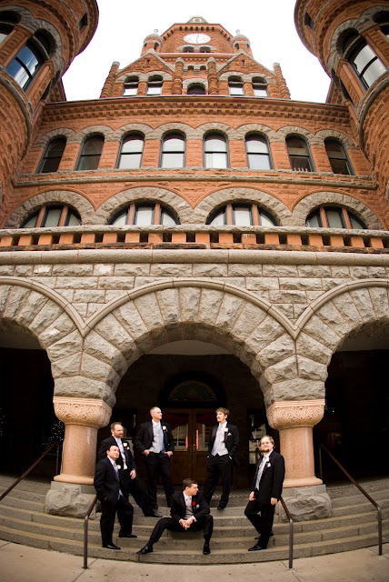
There is almost always a way to make an old building work. Sometimes there are cost issues and that's where I would say local governments can help with TIF payments, tax abatements or other incentives. But often times the developer just wants a blank slate and will say it can't be saved. That may be okay for them, their architect, but for the rest of us, we don't come out ahead.
I have avoided posting about this at first because I don't feel I am a news source. I try to stay more towards the editorial side. However, after thinking it over, I think there is one very important thing that can be learned from this.
Several years ago, there was a proposal to convert the Tower Petroleum to a hotel and demo the Corrigan Tower to make way for a 50-story condo tower. The reason given was that the Corrigan Tower was beyond saving (see post #188 here).
This is the point I want to make. I am a historic preservation advocate. From a cultural perspective (seeing where we came from), from an urban design perspective (old buildings are usually more urban than new) and from a lost perspective (when it is gone, it can never return), I generally side on the case that preservation is paramount, especially when you consider that Dallas' downtown is not short on open, empty or vacant land. Destroying a building when there is a parking lot across the street is a net loss to society and the area.
Back to this particular story. I always suggest taking the idea of demolitions with a critical eye. In this case, there is a developer who wants to do it right. He sees the value in this building. Oftentimes, people look at architecture from the '50's and '60's and say they are ugly and need to be demoed. While I don't disagree with the first, I do with the second. There was a time when Dallasites thought Old Red Courthouse was ugly and needed to be razed. Nowadays, this building is considered a gem. While I sometimes wonder if these buildings will ever be considered beautiful again, I do know they need to be carried over until the next generation, if for no other reason than to avoid a situtation like Old Red.

 |
| These two pictures are from my wedding day. These would have been impossible if prevailing thought of the '40's and '50's had won and Old Red was razed. |
Wednesday, April 18, 2012
The Street Versus the Created Walkway
Alas, another story behind the paywall from the Dallas Morning News' April 18, 2012 edition caught my eye. I would really like to discuss these in greater detail, but apparently the topics of this blog are pay worthy. Yet, not one of you has given me a dime for it.
Anyway, the headline reads Small spaces, big picture: City looks at converting their passages between skyscrapers into inviting pedestrian pathways. While it was more feature rather than news, the gist is buildings built some extra spaces that "are just pass-throughs, while in others there might be a place to sit or even eat. And then there are those spaces where few venture at all."
Karl Stundins, Area Redevelopment Manager for the Dallas Economic Development Department, is looking at making these spaces a bit more inviting. Successful examples in the article are Stone Street Gardens and Browder Street Mall (my take of Browder Street can be found here), while little used spaces listed include the "pathway" around Thanksgiving Tower and the west side of the Central Library.
I want to hammer that point home for a moment. Why are the first two successful but the others aren't? Both Stone and Browder were former streets and most of the buildings there fronted them when they functioned as streets. The later two are really nothing more than useless setbacks. The article can call them walkways or pedestrian paths if they wish, but they aren't. These are setbacks filled with pretty but functionally-useless landscaping. Look at the library picture. Does that look like it was designed for pedestrians? No, there is no entry or exit from the building, no signs, no easy street access and because it is winding, it is not designed for pedestrians to use. In reality, the only people who use this space are the homeless population looking for a little isolation.
Same thing with the Thanksgiving Tower "walkway" that runs on both sides of the building. It is nothing more than meaningless setbacks and landscaping that serve no practical purpose for the urban environment. I touched on this idea in this post, and the article backs that point up. The design of the buildings around Stone Street cause it to be successful. The design around the library cause it to be vacant.
You have to give people a reason to be there. You can paint all the people you want in the rendering, but unless they have a function in that spot, they won't appear.
Stone works by design. Thanksgiving Tower "fails" by design. There would be some architects who say it works as it was designed. It is that isolationist design that permeated the architecture scene in the '70's and '80's. It is also the big reason why Downtown Dallas feels empty.
That said, is what they are discussing a bad idea? As a future post about Uptown will include, this is a contradictory thing for me.
One the one hand, the purist in me sees this as a failure. Poor design still works as designed, with negative consequences for the urban area. I also don't think these linkages will be beneficial for connectivity, since the street grid is already a grid and super-efficient for pedestrian travel. Pedestrians will likely need to get to the bordering street anyway, since the opposite block probably will not have the same pathway. I can see positive effects if two major destinations are a block or two away. But around the library, the Young Street median is on one side and the Interurban Building garage and a parking lot on the other. Unless one is exploring or loitering, there is no need or reason to be here or even to go anywhere else from here.
However, since the wholesale demolition of large parts of downtown is unrealistic, where do we go from here with what we have? Something needs to be done. If Thanksgiving Tower can be converted to make that space somewhat usable, is that a bad thing? For example, if that space was converted to an outdoor patio for a restaurant with a street entrance on Elm, we have solved that problem AND strengthened the street scene on Elm. Is it ideal? No, perfect has long left this site. Is it good? Yes, and certainly an upgrade over what was there.
In fact, in many ways, I see the conversion of the '80's office towers as paramount to turning downtown back into a populated area (this was wish eight in this post). If they do convert the lobbies of these buildings into a more pedestrian-friendly space and make these "leftover spaces," according to Stundins, functional, then it certainly is a win for urban Dallas.
I am a case study guy, and since this hasn't been done on any large scale anywhere, I will withhold judgements until they do their thing. Hopefully my concerns will be mitigated or unsubstantiated. However, I am pleased there is at least dialogue on this topic. That in and of itself is a win.
Anyway, the headline reads Small spaces, big picture: City looks at converting their passages between skyscrapers into inviting pedestrian pathways. While it was more feature rather than news, the gist is buildings built some extra spaces that "are just pass-throughs, while in others there might be a place to sit or even eat. And then there are those spaces where few venture at all."
Karl Stundins, Area Redevelopment Manager for the Dallas Economic Development Department, is looking at making these spaces a bit more inviting. Successful examples in the article are Stone Street Gardens and Browder Street Mall (my take of Browder Street can be found here), while little used spaces listed include the "pathway" around Thanksgiving Tower and the west side of the Central Library.
 |
| A well used pedestrian walkway, Stone Street Gardens. |
 |
| Believe it or not, the wall on the left borders a pedestrian walkway. |
I want to hammer that point home for a moment. Why are the first two successful but the others aren't? Both Stone and Browder were former streets and most of the buildings there fronted them when they functioned as streets. The later two are really nothing more than useless setbacks. The article can call them walkways or pedestrian paths if they wish, but they aren't. These are setbacks filled with pretty but functionally-useless landscaping. Look at the library picture. Does that look like it was designed for pedestrians? No, there is no entry or exit from the building, no signs, no easy street access and because it is winding, it is not designed for pedestrians to use. In reality, the only people who use this space are the homeless population looking for a little isolation.
Same thing with the Thanksgiving Tower "walkway" that runs on both sides of the building. It is nothing more than meaningless setbacks and landscaping that serve no practical purpose for the urban environment. I touched on this idea in this post, and the article backs that point up. The design of the buildings around Stone Street cause it to be successful. The design around the library cause it to be vacant.
You have to give people a reason to be there. You can paint all the people you want in the rendering, but unless they have a function in that spot, they won't appear.
Stone works by design. Thanksgiving Tower "fails" by design. There would be some architects who say it works as it was designed. It is that isolationist design that permeated the architecture scene in the '70's and '80's. It is also the big reason why Downtown Dallas feels empty.
That said, is what they are discussing a bad idea? As a future post about Uptown will include, this is a contradictory thing for me.
One the one hand, the purist in me sees this as a failure. Poor design still works as designed, with negative consequences for the urban area. I also don't think these linkages will be beneficial for connectivity, since the street grid is already a grid and super-efficient for pedestrian travel. Pedestrians will likely need to get to the bordering street anyway, since the opposite block probably will not have the same pathway. I can see positive effects if two major destinations are a block or two away. But around the library, the Young Street median is on one side and the Interurban Building garage and a parking lot on the other. Unless one is exploring or loitering, there is no need or reason to be here or even to go anywhere else from here.
However, since the wholesale demolition of large parts of downtown is unrealistic, where do we go from here with what we have? Something needs to be done. If Thanksgiving Tower can be converted to make that space somewhat usable, is that a bad thing? For example, if that space was converted to an outdoor patio for a restaurant with a street entrance on Elm, we have solved that problem AND strengthened the street scene on Elm. Is it ideal? No, perfect has long left this site. Is it good? Yes, and certainly an upgrade over what was there.
In fact, in many ways, I see the conversion of the '80's office towers as paramount to turning downtown back into a populated area (this was wish eight in this post). If they do convert the lobbies of these buildings into a more pedestrian-friendly space and make these "leftover spaces," according to Stundins, functional, then it certainly is a win for urban Dallas.
I am a case study guy, and since this hasn't been done on any large scale anywhere, I will withhold judgements until they do their thing. Hopefully my concerns will be mitigated or unsubstantiated. However, I am pleased there is at least dialogue on this topic. That in and of itself is a win.
Friday, April 13, 2012
Change of Heart in Deep Ellum
In my previous post about the saga of a new charter school, from Uplift Education, in Deep Ellum, I expressed my concern that the truce between Deep Ellum stakeholders and the school after the removal of the 300 foot barrier between schools and alcohol establishments could be tempered by something else. My fear was that some of these folks were against it no matter what and we grabbing for whatever reason they could to oppose the measure. Thankfully, for some, the 300 foot barrier was the only reason.
As reported in the Wednesday edition of the Dallas Morning News, the neighborhood is coming around (it is behind the paywall). Here's some quotes I thought were great to hear.
Many of these sentiments I echoed in the past, more than once. It is good to see that I was partially wrong in that alcohol sales were the stumbling block for most of the dissenters.
As reported in the Wednesday edition of the Dallas Morning News, the neighborhood is coming around (it is behind the paywall). Here's some quotes I thought were great to hear.
And many locals are now accepting, if not embracing, the arrival of all those new kids on the block.
" I really feel like all the school's going to do is add to the neighborhood's culture," said Stephanie Schumacher, owner of La Grange, a nearby music venue.
...
"We actually reached out to them," he (Clint Barlow, owner of Trees) said. "We'd like to help with some sort of band camp if they have enough [students] interested. ... The kids might find an outlet to express themselves in a positive way here."
...
"There are really good partnerships that can happen there," he (Tanner Hockensmith, director at Life in Deep Ellum) said. "One thing that is lost in eduaction is the arts. ... I think Deep Ellum has always been an eclectic place, and it's perfect for the school."
...
Hockensmith said some business owners may have to get used to the change, but the adjustment period will be short.
"The start of the conversations were 'How can we coexist?' Now it's, 'How can we assist you?' he said. "Five years down the road, that school's going to be the fabric of this neighborhood."Many of these sentiments I echoed in the past, more than once. It is good to see that I was partially wrong in that alcohol sales were the stumbling block for most of the dissenters.
Tuesday, March 6, 2012
Two Quick Points
I don't want to make a habit of commenting on Deep Ellum too much, though two of my top three posts directly relate to Deep Ellum, but I did want to add a bit more to the discussion. In this previous post, I said
We were told by the stakeholders in the area that this [300-foot barrier between alcohol sales and school]was their main concern. When this option was discussed during the last few weeks, there were other concerns raised, indicating to me an unwillingness to accept a high school within the area and that reasons were given to make it not work.
I want to amend that by now saying some stakeholders. Barry Annino, head of the Deep Ellum Foundation, was quoted in the Dallas Morning News on February 23 as saying, "We've worked everything out. I think it is something we need to do anyway, something we didn't realize. In the long term, we want more charter schools. And if we make this addendum we can all work together."
I am at least glad that some in Deep Ellum get it. Annino has the best in mind for Deep Ellum, but he also has property owners to represent. He did a balancing act, got the heart of the issue solved and realized this is a good thing for the neighborhood. Kudos to him for a nice job.
Also in the Dallas Morning News, Steve Brown's real estate report (I simply can't get enough of these) on March 2 was about the housing market in my neighborhood, Downtown. While it was somewhat of a fluff piece, it did highlight several things that planners have been saying for a decade, much of it contained in various places in this blog. Urban areas are attractive to folks 35 and under. People want to be able to walk places or take transit. Rents are high because the demand is high and therefore the market can afford (and really needs) to build more.
What I want to post are physical numbers given in the story. Currently, there are near 5,300 residential units in downtown containing roughly 7,400 people. Downtown needs 10-12,000 total to be able to sustain itself. 600 units are being constructed right now. The rest of the story lists a few or those projects. One apartment analyst is quoted as saying that Dallas falls behind comparable cities like Houston, Atlanta and Denver in terms of downtown residences. I am whole-heartedly unsurprised.
I post those numbers for two reasons. The first is pure fascination. These numbers are nice to see, especially if you compare them to the past, when there wasn't much. However, the second reason is that there is no context here. How do cities like Fort Worth, San Antonio or even the burbs around Dallas like Plano, McKinney or Carrollton have active downtown's with far less residences? The answer is design. This piece, much like Dallas leaders in general, totally overlook this in favor of more. If I were to build a complex on the southeast side of the Farmers Market and another on the northwest side of the West End that contained the remaining 4,700 people, much of downtown would remain near the same because they weren't adequately integrated into the current urban fabric. A few hundred units sprinkled over a ten-square block area would do wonders for vibrancy. Putting them in a concentrated area on the fringes wouldn't.
It also doesn't account for the urban design of the actual developments. Main Street is vibrant because most every building there either was built prior to WWII or was designed to respect the street and pedestrians. Meanwhile, one block over on Elm is dead. Many of the buildings that make Main attractive make Elm unattractive. Adding more units won't rectify it. Designing it better would. For example, Third Rail Lofts has an alley between it and the Davis Building and its garage. Yet the entrance to the TRL garage fronts Elm Street.
If the city were to help calm streets, like Elm and Commerce for example, then development would mirror that. They could also do other things like reduce parking requirements or allow one existing garage to serve multiple buildings. This would cut down on curb cuts in the streets, allowing pedestrians to feel more comfortable, rather than feel like they are playing a real life game of Frogger.
Bottomline: numbers are great to analyzation, but context is needed for understanding. I wish Dallas were really better at distinguishing these.
We were told by the stakeholders in the area that this [300-foot barrier between alcohol sales and school]was their main concern. When this option was discussed during the last few weeks, there were other concerns raised, indicating to me an unwillingness to accept a high school within the area and that reasons were given to make it not work.
I want to amend that by now saying some stakeholders. Barry Annino, head of the Deep Ellum Foundation, was quoted in the Dallas Morning News on February 23 as saying, "We've worked everything out. I think it is something we need to do anyway, something we didn't realize. In the long term, we want more charter schools. And if we make this addendum we can all work together."
I am at least glad that some in Deep Ellum get it. Annino has the best in mind for Deep Ellum, but he also has property owners to represent. He did a balancing act, got the heart of the issue solved and realized this is a good thing for the neighborhood. Kudos to him for a nice job.
Also in the Dallas Morning News, Steve Brown's real estate report (I simply can't get enough of these) on March 2 was about the housing market in my neighborhood, Downtown. While it was somewhat of a fluff piece, it did highlight several things that planners have been saying for a decade, much of it contained in various places in this blog. Urban areas are attractive to folks 35 and under. People want to be able to walk places or take transit. Rents are high because the demand is high and therefore the market can afford (and really needs) to build more.
What I want to post are physical numbers given in the story. Currently, there are near 5,300 residential units in downtown containing roughly 7,400 people. Downtown needs 10-12,000 total to be able to sustain itself. 600 units are being constructed right now. The rest of the story lists a few or those projects. One apartment analyst is quoted as saying that Dallas falls behind comparable cities like Houston, Atlanta and Denver in terms of downtown residences. I am whole-heartedly unsurprised.
I post those numbers for two reasons. The first is pure fascination. These numbers are nice to see, especially if you compare them to the past, when there wasn't much. However, the second reason is that there is no context here. How do cities like Fort Worth, San Antonio or even the burbs around Dallas like Plano, McKinney or Carrollton have active downtown's with far less residences? The answer is design. This piece, much like Dallas leaders in general, totally overlook this in favor of more. If I were to build a complex on the southeast side of the Farmers Market and another on the northwest side of the West End that contained the remaining 4,700 people, much of downtown would remain near the same because they weren't adequately integrated into the current urban fabric. A few hundred units sprinkled over a ten-square block area would do wonders for vibrancy. Putting them in a concentrated area on the fringes wouldn't.
It also doesn't account for the urban design of the actual developments. Main Street is vibrant because most every building there either was built prior to WWII or was designed to respect the street and pedestrians. Meanwhile, one block over on Elm is dead. Many of the buildings that make Main attractive make Elm unattractive. Adding more units won't rectify it. Designing it better would. For example, Third Rail Lofts has an alley between it and the Davis Building and its garage. Yet the entrance to the TRL garage fronts Elm Street.
If the city were to help calm streets, like Elm and Commerce for example, then development would mirror that. They could also do other things like reduce parking requirements or allow one existing garage to serve multiple buildings. This would cut down on curb cuts in the streets, allowing pedestrians to feel more comfortable, rather than feel like they are playing a real life game of Frogger.
Bottomline: numbers are great to analyzation, but context is needed for understanding. I wish Dallas were really better at distinguishing these.
Monday, February 13, 2012
Urban Bus Reductions
In response to anonymous, I am going to break down how further changes to the bus system in the upcoming service changes will have a negative impact on the urban area. Similar to the simplistic method I mentioned in this post, identifying the urban areas is the first step. In my opinion, the urban neighborhoods are Downtown, Uptown, The Cedars, Deep Ellum Knox-Henderson, Oak Lawn and Bishop Arts. Upcoming neighborhoods that are close include Cedar Springs, Design District, Expo Park and North Oak Cliff (some might differ with my opinion that this is emerging. I say that because there are still many suburban designed areas, with large amounts of setbacks and parking. That also makes it more of an emerging urban area when there is no consensus). I don't include anything that is not contiguous with the urban core such as Mockingbird Station or the Medical District.
From here, identifying the buses within these neighborhoods will illustrate my point. The buses that are scheduled for adjustment in the first phase are the 21 (BA, NOC, D, U, KH), 27 (D, U), 35 (D, C), 59 (U, D, NOC), 110 (D), 111 (D), 155 (D, C), 183 (D, U), 202 (D), 208 (D), 210 (D) and 521 (U, KH). Those scheduled for the second phase are the 31 (D, U, OL), 39 (D, U, OL, CS), 49 (D, U, DD), 51 (D, U, OL, CS), 207 (D) and 283 (D).
Now several of these buses can be stricken from the discussion, the 202, 210 and the 207, as new rail additions are replacing the current service. The 283 is canceling a suburban portion of the route. The 208 is a new service. As a whole, the express route 200 series buses are of little use as urban travel. They are merely ways of transporting suburban workers to urban workplaces. While this is important, I have established previously that commuter services carry far less than their urban counterparts. Similar to the 200's is the 183, as it is adding portions to its suburban segment. While this is a good thing, it is also of little use in urban travel.
I would also excluded the 110 and the 111. Leaving downtown, they both travel over two routes toward Far East Dallas. After the change, each will be operating on only one portion, with the same total coverage as before. The 111 will have reduced times, which I will touch on in a minute, but since the 100 series are semi-express, the same rules apply, there is little the urban transportation gain from these routes.
Consequently, we can group several of the routes under their respective negative change. First up is the 35 and 49. These are going to be reduced in frequency. This means less buses plying the streets and connecting the urban areas. It is no secret that higher frequencies lead to higher ridership along the same route. Obviously, cost has to come into play, which is the reason some routes operate quite a bit more than others. If money were no object, every route would have headway's less than five minutes apart and operate 24 hours a day. Sadly, we live in the real world and DART planners have to balance operating costs with service provided. While I don't necessarily disagree with the change, it will have a negative impact on urban transport.
The 155 serves Lamar Street, but the frequency is so low that it's loss will mean very little. It's primary function was operating with limited express from the South Ledbetter area to downtown. Eliminating it will require an extra transfer, but the ridership wasn't that high anyway. It's local service in South Dallas was already served by existing rail feeders so there is no need to add a shorter rail feeder route to replace any loss of service. Again, were this an ideal setting, this bus wouldn't go anywhere, but given the constraints DART faces, I am fine with this one. However, it is still worth acknowledging its negative impact.
Another grouping is the 21, 27, 51, 59 and 39. These will have parts or all of their route eliminated. Obviously, truncated routes negatively effects the urban neighborhoods by no longer offering its services in that corridor. In the case of the 21, part of that route is being added back into a new route, the 521, but not all. It also now means an extra transfer is needed, as is the case of the 39 and the 524. The 524 is picking up the truncated part of the 39. That now means those using that portion of the service will now have to make that transfer. The 27's elimination doesn't bother me too much. It basically duplicated the Green Line, since there is very little on that route between Downtown and Parkland to act as destinations for passengers (the Harwod District in Uptown is the only exception). Some folks addressed their concern with this one in the public meetings, but I think a reshuffling of the circular's scheduling within the Medical District will alleviate some of those issues.
The 31 was addressed in the post linked above, but I'll briefly repeat. The 31 will be pulled from service on Oak Lawn to pick up the eliminated urban portion of the 51. This means a major urban street has no local bus service from downtown and only one route overall. In many ways, a lot of these changes fall under this umbrella too. McKinney has less local bus destinations if the 21 is pulled. Elm and Commerce get less buses now with the reduced headway's and eliminations, it is very easy to travel east-west in downtown because of all the different buses. It will be a little less so now. Other urban streets like San Jacinto, Pearl, Harwood, Lamar and Houston will similarly be effected.
Let me repeat, this is not a criticism of the planner's proposals but merely a look at one set of negative effects. I'd be more upset if they were trying to make a $50 million budget surplus into $60 with these changes. But as it is, they are trying to break even. Some environmental justice folks would be upset that part of the reason for the cuts is the debt incurred for building the rail system. I share part of their position, but I also understand the politics involved. I know, surprise, surprise, something involving tax dollars and public infrastructure involves politics, but that is the way of things.
From here, identifying the buses within these neighborhoods will illustrate my point. The buses that are scheduled for adjustment in the first phase are the 21 (BA, NOC, D, U, KH), 27 (D, U), 35 (D, C), 59 (U, D, NOC), 110 (D), 111 (D), 155 (D, C), 183 (D, U), 202 (D), 208 (D), 210 (D) and 521 (U, KH). Those scheduled for the second phase are the 31 (D, U, OL), 39 (D, U, OL, CS), 49 (D, U, DD), 51 (D, U, OL, CS), 207 (D) and 283 (D).
Now several of these buses can be stricken from the discussion, the 202, 210 and the 207, as new rail additions are replacing the current service. The 283 is canceling a suburban portion of the route. The 208 is a new service. As a whole, the express route 200 series buses are of little use as urban travel. They are merely ways of transporting suburban workers to urban workplaces. While this is important, I have established previously that commuter services carry far less than their urban counterparts. Similar to the 200's is the 183, as it is adding portions to its suburban segment. While this is a good thing, it is also of little use in urban travel.
I would also excluded the 110 and the 111. Leaving downtown, they both travel over two routes toward Far East Dallas. After the change, each will be operating on only one portion, with the same total coverage as before. The 111 will have reduced times, which I will touch on in a minute, but since the 100 series are semi-express, the same rules apply, there is little the urban transportation gain from these routes.
Consequently, we can group several of the routes under their respective negative change. First up is the 35 and 49. These are going to be reduced in frequency. This means less buses plying the streets and connecting the urban areas. It is no secret that higher frequencies lead to higher ridership along the same route. Obviously, cost has to come into play, which is the reason some routes operate quite a bit more than others. If money were no object, every route would have headway's less than five minutes apart and operate 24 hours a day. Sadly, we live in the real world and DART planners have to balance operating costs with service provided. While I don't necessarily disagree with the change, it will have a negative impact on urban transport.
The 155 serves Lamar Street, but the frequency is so low that it's loss will mean very little. It's primary function was operating with limited express from the South Ledbetter area to downtown. Eliminating it will require an extra transfer, but the ridership wasn't that high anyway. It's local service in South Dallas was already served by existing rail feeders so there is no need to add a shorter rail feeder route to replace any loss of service. Again, were this an ideal setting, this bus wouldn't go anywhere, but given the constraints DART faces, I am fine with this one. However, it is still worth acknowledging its negative impact.
Another grouping is the 21, 27, 51, 59 and 39. These will have parts or all of their route eliminated. Obviously, truncated routes negatively effects the urban neighborhoods by no longer offering its services in that corridor. In the case of the 21, part of that route is being added back into a new route, the 521, but not all. It also now means an extra transfer is needed, as is the case of the 39 and the 524. The 524 is picking up the truncated part of the 39. That now means those using that portion of the service will now have to make that transfer. The 27's elimination doesn't bother me too much. It basically duplicated the Green Line, since there is very little on that route between Downtown and Parkland to act as destinations for passengers (the Harwod District in Uptown is the only exception). Some folks addressed their concern with this one in the public meetings, but I think a reshuffling of the circular's scheduling within the Medical District will alleviate some of those issues.
The 31 was addressed in the post linked above, but I'll briefly repeat. The 31 will be pulled from service on Oak Lawn to pick up the eliminated urban portion of the 51. This means a major urban street has no local bus service from downtown and only one route overall. In many ways, a lot of these changes fall under this umbrella too. McKinney has less local bus destinations if the 21 is pulled. Elm and Commerce get less buses now with the reduced headway's and eliminations, it is very easy to travel east-west in downtown because of all the different buses. It will be a little less so now. Other urban streets like San Jacinto, Pearl, Harwood, Lamar and Houston will similarly be effected.
Let me repeat, this is not a criticism of the planner's proposals but merely a look at one set of negative effects. I'd be more upset if they were trying to make a $50 million budget surplus into $60 with these changes. But as it is, they are trying to break even. Some environmental justice folks would be upset that part of the reason for the cuts is the debt incurred for building the rail system. I share part of their position, but I also understand the politics involved. I know, surprise, surprise, something involving tax dollars and public infrastructure involves politics, but that is the way of things.
Tuesday, December 6, 2011
Then and now
Today I want to hammer home a point I brought up when comparing the downtown's of San Antonio and Dallas(here and here). One of my main points was that much more of San Antonio's downtown is composed of historic, pre-WWII buildings than Dallas and it is that fact more than any other that contributes to the vitality of San Antonio's urban core. Meanwhile, Dallas destroyed those very buildings and replaced them with fortress office towers or parking lots.
Over a year ago, I critiqued Main Street Gardens, and one of the things I liked was the recognition of the history of that area, the old parking garage sign, the view corridors toward the old city hall and the sign at the corner of Harwood and Main revealing a bit about the block and surrounding areas. It is that sign that I want to direct your attention now.
Here's an amateur photo.
 It shows the property and surrounding areas as they evolved from a residential area to part of the commercial core of downtown Dallas.
In 1885, the smattering of black dots represents the "improvements" to the property, or in layman's terms, buildings on the property. No surprise, as was the norm then, the houses are close to the street, with minimal setbacks and a decent backyard. If you look at the west side of St. Paul, you can see the beginnings of the classical commercial building of that time, long rectangular structures that were usually restaurants or shops on the ground floor and offices or residences above.
Now in 1905 and 1921, there are quite a bit more of those rectangular buildings. In 1921, by my count, there were 27 structures on the north side of Main and 19 on the south part. That is 46 places for people to walk to or from to eat, shop, work or live. That activity creates a vibrant street scene. On Commerce, I count 17 building on the north part of the street and 22 on the south. Again, that creates 39 places for people to walk to or from, creating a vibrant urban setting. Add in the fact that both streets were hubs of the city's streetcar system and it is no wonder there were lots of people on the streets of downtown back in the day.
Even when looking at 1959, there are far more structures than exist today, 26 on Main, 17 on Commerce (though the Grand Hotel did have several street level retail spaces) and one on Harwood.
When compared to when Main Street Gardens opened, 12 on Main, 14 on Commerce, (a half block more is revealed on each side than in the other pictures) there are far less places for people to go to or from and therefore, far less people on the streets. Notice the slow decline in destinations: 85 places in 1921, 43 in 1959, 26 in 2009. We currently have only 30 percent of what was available 90 years ago.
Now, to be fair, some places, like the department store on the northeast corner of Main and St. Paul (that is now a loft building where I live), demolished 12 structures and replaced them with two, but the newer addition created just as much if not more foot traffic than what was there. Sadly, there is also the case of Comerica Tower, which replaced at least five structures (in the picture, as I know there were more towards Ervay) that were pedestrian-friendly with one that is not. On the southeast section of Commerce and Harwood, about a dozen buildings were razed and made parking.
Sometimes I wonder what goes on in the process at City Hall. We know what works. We know what doesn't. If the stated goal is to create a vibrant urban core, go back to doing what you were before when it was and stop doing the things that have gotten us to where we are now. Trying to do the same thing and hoping for different results is the definintion of insanity.
Over a year ago, I critiqued Main Street Gardens, and one of the things I liked was the recognition of the history of that area, the old parking garage sign, the view corridors toward the old city hall and the sign at the corner of Harwood and Main revealing a bit about the block and surrounding areas. It is that sign that I want to direct your attention now.
Here's an amateur photo.

In 1885, the smattering of black dots represents the "improvements" to the property, or in layman's terms, buildings on the property. No surprise, as was the norm then, the houses are close to the street, with minimal setbacks and a decent backyard. If you look at the west side of St. Paul, you can see the beginnings of the classical commercial building of that time, long rectangular structures that were usually restaurants or shops on the ground floor and offices or residences above.
Now in 1905 and 1921, there are quite a bit more of those rectangular buildings. In 1921, by my count, there were 27 structures on the north side of Main and 19 on the south part. That is 46 places for people to walk to or from to eat, shop, work or live. That activity creates a vibrant street scene. On Commerce, I count 17 building on the north part of the street and 22 on the south. Again, that creates 39 places for people to walk to or from, creating a vibrant urban setting. Add in the fact that both streets were hubs of the city's streetcar system and it is no wonder there were lots of people on the streets of downtown back in the day.
Even when looking at 1959, there are far more structures than exist today, 26 on Main, 17 on Commerce (though the Grand Hotel did have several street level retail spaces) and one on Harwood.
When compared to when Main Street Gardens opened, 12 on Main, 14 on Commerce, (a half block more is revealed on each side than in the other pictures) there are far less places for people to go to or from and therefore, far less people on the streets. Notice the slow decline in destinations: 85 places in 1921, 43 in 1959, 26 in 2009. We currently have only 30 percent of what was available 90 years ago.
Now, to be fair, some places, like the department store on the northeast corner of Main and St. Paul (that is now a loft building where I live), demolished 12 structures and replaced them with two, but the newer addition created just as much if not more foot traffic than what was there. Sadly, there is also the case of Comerica Tower, which replaced at least five structures (in the picture, as I know there were more towards Ervay) that were pedestrian-friendly with one that is not. On the southeast section of Commerce and Harwood, about a dozen buildings were razed and made parking.
Sometimes I wonder what goes on in the process at City Hall. We know what works. We know what doesn't. If the stated goal is to create a vibrant urban core, go back to doing what you were before when it was and stop doing the things that have gotten us to where we are now. Trying to do the same thing and hoping for different results is the definintion of insanity.
Tuesday, November 8, 2011
Update from the Bay
About ten months ago, I briefly chronicled the San Francisco area's strategies for battling congestion. Under the category of congestion pricing, tolls for area bridges and roadways went up when use went up. While many people look at roadway capacity as a supply-and-demand function, they don't like to think of those same economic forces are applied to roadways, if they actually have to pay for it. Which in that essence is why it actually relieves congestion.
The San Francisco Chronicle reported on a study that followed up on the strategy, and it appears to be working. While carpooling (a dubious attempt at congestion reduction) has decreased, so has main lane use. Transit ridership is up, vehicle miles traveled are down and travel time savings is up, tremendously in some cases. The extreme example is I-880, which saw its average travel times reduced by half!
The main problem with congestion pricing implementation on a wide scale is the lack of available case studies. However, of the ones that are out there, it appears that adding a market approach actually reduces congestion, more so than any other attempt that has been tried before.
The San Francisco Chronicle reported on a study that followed up on the strategy, and it appears to be working. While carpooling (a dubious attempt at congestion reduction) has decreased, so has main lane use. Transit ridership is up, vehicle miles traveled are down and travel time savings is up, tremendously in some cases. The extreme example is I-880, which saw its average travel times reduced by half!
The main problem with congestion pricing implementation on a wide scale is the lack of available case studies. However, of the ones that are out there, it appears that adding a market approach actually reduces congestion, more so than any other attempt that has been tried before.
Wednesday, November 2, 2011
San Antonio, an urban oasis?
How timely that just a bit after my family and I visited San Antonio, Yahoo! Travel and Forbes but SA in their top 10 mid and small city downtown's, though how San Antonio with 1.3 million people, let alone Chicago, is considered mid-sized is beyond me.
Per the article:
For those who haven’t yet visited San Antonio, the city conjures up images of a tragic and bloody last stand at The Alamo. But for anyone who has visited, the city is more than just home to one of the most famous historical sites in the West. The San Antonio River Walk is perhaps the most beautiful part of the city, creating a verdant pathway lined with colorful café umbrellas that winds its way through downtown, offering up a bevy of shops, restaurants, and bars on the way. Tour downtown, follow the river by foot or tour it by boat, and save your visit to the Alamo for the late afternoon, when the sun is in retreat and you’ll have more to remember from your trip than just an historic and valiant defeat.
A bit brief, though what is there is accurate. San Antonio really has a lot of what folks like me, particularly in the Sunbelt cities, advocate.
We found it to be quite an active place, which begs the question of why. Though there is not one singular answer, and I will get into many shortly, the big answer is history. Obviously, the large scale historical framework is there with the Alamo and the Tower of the Americas. But there is also the smaller places that give it the historical feel. The difference between the Alamo and the other missionary sites is that the Texas soldiers choose that site as its fort. It isn't out of the question to think that the Alamo could be just another historical site in SA, but that a current missionary settlement building could have been where the battle was fought in 1836. These smaller missionary sites have been converted other uses, but their history remains. Often these uses are public, like a theater or performing arts venue.
But that isn't all the history. Six of the top 15 tallest buildings were completed before 1960. Five were built before WWII. To put it in perspective, Dallas has one before 1960 and none before WWII.
This is significant in two major ways. First, older buildings tend to be better urban buildings than those built between 1960 and 2000. There are ground floor retail locations and even those that aren't don't alienate those who are walking near the property. They are also better for the pedestrian scale. The materials are usually softer and the design is generally warmer to people up close. The second is that when a building built before WWII is demolished, the replacement is not of the same quality. More often than not, especially in the southern half of the U.S., that replacement is a parking lot, a known pedestrian adversary. By having large quantities of these buildings, San Antonio guarantees an active street scene.
One of the most famous features of San Antonio is of course the River Walk. From a planning standpoint, this area fascinates me. Here was an area, several decades ago, that was a liability. When it flooded, there was damage and death. It was considered no more than a ditch at the turn of the century. The look and smell made the locals call it an eyesore. In the '20's, plans called for taming the river, including paving it, a la the Los Angeles River. The local Conservation Society took exception to the idea. They worked with the mayor and came up with a beautification project that would turn into the River Walk. The idea was very unpopular and it wasn't until the Works Progress Administration offered funds that the project got off the ground on a large scale.
Aside from paving and the actual completion, if I inserted the Trinity River here, would that sound familiar? What would SA look like today, had this area been paved over and become an open drainage ditch? This is a major tourist attraction because it is unique, beautiful and at the same time functional in flood control. SA took an asset, improved it and has been reaping the rewards since then.
Here's some pictures:

This is a great illustrator that the River Walk is both beautiful and functional. Instead of concrete tip to toe, stone work accents landscaping that fits the area, ie that is natural. If this were done today, one of two things would be the outcome. Either the area would be entirely concrete grey, to contain costs, or consist of imported granite and exotic vegetation that required extensive maintenance and died frequently.

I like this one as it illustrates the relationship between the street, the river and the built environment. I have heard that San Antonio is an example of how you can have a divided streetscape, basically debating that the tunnels can be successful within downtown Dallas. I feel differently. What you see above is the extension of the streetscape, not another entitly, like the tunnel system. On Friday night, we had dinner at Casa Rio, a restaurant with entrances at both the river and street level. While that can be achieved in the confines of a tunnel or skywalk, it is much harder, particularly when the buildings in question are post-modern office buildings.
This final shot also illustrates how well connected the two realms are.

It is hard NOT to find the street level in San Antonio. Stairs are plentiful and there are numerous times where it is easier to go to the other side of the river by going up the stairs, crossing the street and walking back down. While, as before, this may be possible in the tunnels, it is very hard to actually achieve.
The River Walk itself is wonderfully pedestrian-friendly. Yet, so were the streets above, which had just as much activity as below. It was easy to see how the design fed one to the other. Each would be less used were the other not there.
My main focus was what they did well in creating downtown SA. It is an area that is a bit odd compared to many cities. The tallest structure is the aforementioned Tower of the America's, it's tallest skyscraper is a hotel, the Marriott Rivercenter, and the tallest office, Weston Centre, is only the third tallest in the city. It is hard to find a city whose tallest structure is not an office tower. This represents downtown SA in a measurable way.
They don't focus on what other cities did or try to incorporate an off-the-shelf-planning idea. Instead, they took stock of what they had, and strengthened it. They didn't try to import a modern Times Square. They didn't try to build the tallest office building. They didn't call the latest and hottest architect to build a fancy civic building.
When compared to Dallas, they don't have a high downtown residential population. They don't have a huge amount of office space. They have more hotel rooms, but not that drastic a difference. Yet, despite that downtown Dallas should have a higher population within downtown at all times, but the streets don't reflect it. San Antonio has accomplished this by embracing what they are and what they were. Dallas has ran from it, trying hard to be more than it is.
Just to show this point, compare the two big historical sites, Dallas' Dealey Plaza to San Antonio's Alamo. Both were the location of a tragedy, though the Alamo was significant to Texas' independence, while JFK's assassination were black eyes to folks in Dallas. Both have museums dedicated to the event. After that, it is night and day.
There are lots of things to do around the Alamo after or before you go. The River Center Mall and the River Walk allow for eating and shopping. As it stands now, all that is near Dealey Plaza in that regard is the Sixth Floor Museum's cafe (not open past 6pm and only on weekdays), a Subway and a western-themed gift shop. Not that far, but out of eyesight of the Plaza are a few more restaurants. If you want to visit and pay your county tax bill, that can be done at the Records Building. If you want to visit then join the army, you can accomplish that at 207 South Houston. If you want to visit Dealey Plaza before your county court date, the fortress-like George Allen Courts building is adjacent. Aside from the museum and and its cafe, the only directly adjacent building that caters to visitors would be Old Red Courthouse, though if you are at Dealey Plaza, it is only a building that looks neat. Otherwise, visitors have no idea what it is. If visitors know that the JFK Memorial is only a block away (some don't) it is highly underwhelming and only makes sense when you realize it is nothing more than a garage topper.
It is this scattering of parts that make downtown Dallas so lackadaisical in activity, particularly when compared with SA. Compactness plays a huge factor in urban street vibrancy. Dallas doesn't have it, San Antonio does.
Per the article:
For those who haven’t yet visited San Antonio, the city conjures up images of a tragic and bloody last stand at The Alamo. But for anyone who has visited, the city is more than just home to one of the most famous historical sites in the West. The San Antonio River Walk is perhaps the most beautiful part of the city, creating a verdant pathway lined with colorful café umbrellas that winds its way through downtown, offering up a bevy of shops, restaurants, and bars on the way. Tour downtown, follow the river by foot or tour it by boat, and save your visit to the Alamo for the late afternoon, when the sun is in retreat and you’ll have more to remember from your trip than just an historic and valiant defeat.
A bit brief, though what is there is accurate. San Antonio really has a lot of what folks like me, particularly in the Sunbelt cities, advocate.
We found it to be quite an active place, which begs the question of why. Though there is not one singular answer, and I will get into many shortly, the big answer is history. Obviously, the large scale historical framework is there with the Alamo and the Tower of the Americas. But there is also the smaller places that give it the historical feel. The difference between the Alamo and the other missionary sites is that the Texas soldiers choose that site as its fort. It isn't out of the question to think that the Alamo could be just another historical site in SA, but that a current missionary settlement building could have been where the battle was fought in 1836. These smaller missionary sites have been converted other uses, but their history remains. Often these uses are public, like a theater or performing arts venue.
But that isn't all the history. Six of the top 15 tallest buildings were completed before 1960. Five were built before WWII. To put it in perspective, Dallas has one before 1960 and none before WWII.
 |
| Aside from the parking garage on the left, this vibrant street scene is composed entirely of pre-WWII buildings. |
This is significant in two major ways. First, older buildings tend to be better urban buildings than those built between 1960 and 2000. There are ground floor retail locations and even those that aren't don't alienate those who are walking near the property. They are also better for the pedestrian scale. The materials are usually softer and the design is generally warmer to people up close. The second is that when a building built before WWII is demolished, the replacement is not of the same quality. More often than not, especially in the southern half of the U.S., that replacement is a parking lot, a known pedestrian adversary. By having large quantities of these buildings, San Antonio guarantees an active street scene.
 |
| Notice how this older building respects the street, and therefore enlivens it. |
Aside from paving and the actual completion, if I inserted the Trinity River here, would that sound familiar? What would SA look like today, had this area been paved over and become an open drainage ditch? This is a major tourist attraction because it is unique, beautiful and at the same time functional in flood control. SA took an asset, improved it and has been reaping the rewards since then.
Here's some pictures:

This is a great illustrator that the River Walk is both beautiful and functional. Instead of concrete tip to toe, stone work accents landscaping that fits the area, ie that is natural. If this were done today, one of two things would be the outcome. Either the area would be entirely concrete grey, to contain costs, or consist of imported granite and exotic vegetation that required extensive maintenance and died frequently.

I like this one as it illustrates the relationship between the street, the river and the built environment. I have heard that San Antonio is an example of how you can have a divided streetscape, basically debating that the tunnels can be successful within downtown Dallas. I feel differently. What you see above is the extension of the streetscape, not another entitly, like the tunnel system. On Friday night, we had dinner at Casa Rio, a restaurant with entrances at both the river and street level. While that can be achieved in the confines of a tunnel or skywalk, it is much harder, particularly when the buildings in question are post-modern office buildings.
This final shot also illustrates how well connected the two realms are.

It is hard NOT to find the street level in San Antonio. Stairs are plentiful and there are numerous times where it is easier to go to the other side of the river by going up the stairs, crossing the street and walking back down. While, as before, this may be possible in the tunnels, it is very hard to actually achieve.
The River Walk itself is wonderfully pedestrian-friendly. Yet, so were the streets above, which had just as much activity as below. It was easy to see how the design fed one to the other. Each would be less used were the other not there.
My main focus was what they did well in creating downtown SA. It is an area that is a bit odd compared to many cities. The tallest structure is the aforementioned Tower of the America's, it's tallest skyscraper is a hotel, the Marriott Rivercenter, and the tallest office, Weston Centre, is only the third tallest in the city. It is hard to find a city whose tallest structure is not an office tower. This represents downtown SA in a measurable way.
They don't focus on what other cities did or try to incorporate an off-the-shelf-planning idea. Instead, they took stock of what they had, and strengthened it. They didn't try to import a modern Times Square. They didn't try to build the tallest office building. They didn't call the latest and hottest architect to build a fancy civic building.
When compared to Dallas, they don't have a high downtown residential population. They don't have a huge amount of office space. They have more hotel rooms, but not that drastic a difference. Yet, despite that downtown Dallas should have a higher population within downtown at all times, but the streets don't reflect it. San Antonio has accomplished this by embracing what they are and what they were. Dallas has ran from it, trying hard to be more than it is.
Just to show this point, compare the two big historical sites, Dallas' Dealey Plaza to San Antonio's Alamo. Both were the location of a tragedy, though the Alamo was significant to Texas' independence, while JFK's assassination were black eyes to folks in Dallas. Both have museums dedicated to the event. After that, it is night and day.
There are lots of things to do around the Alamo after or before you go. The River Center Mall and the River Walk allow for eating and shopping. As it stands now, all that is near Dealey Plaza in that regard is the Sixth Floor Museum's cafe (not open past 6pm and only on weekdays), a Subway and a western-themed gift shop. Not that far, but out of eyesight of the Plaza are a few more restaurants. If you want to visit and pay your county tax bill, that can be done at the Records Building. If you want to visit then join the army, you can accomplish that at 207 South Houston. If you want to visit Dealey Plaza before your county court date, the fortress-like George Allen Courts building is adjacent. Aside from the museum and and its cafe, the only directly adjacent building that caters to visitors would be Old Red Courthouse, though if you are at Dealey Plaza, it is only a building that looks neat. Otherwise, visitors have no idea what it is. If visitors know that the JFK Memorial is only a block away (some don't) it is highly underwhelming and only makes sense when you realize it is nothing more than a garage topper.
It is this scattering of parts that make downtown Dallas so lackadaisical in activity, particularly when compared with SA. Compactness plays a huge factor in urban street vibrancy. Dallas doesn't have it, San Antonio does.
Tuesday, May 24, 2011
360 Chapter Four, Section Two & Three
Key to any vibrant urban area is the street scene. Section two dissects the current and gives it suggestions for the future, though since it has been suburbanized for the last sixty years or so, it is a bigger task than the planners can overcome, but at least the majority of the suggestions are sound.
The first page is encouraging as MIG acknowledges that fundamental changes would be needed to accommodate more than just cars. To do this, they introduce a new street classification, or a hierarchy. From the plan:

The first page is encouraging as MIG acknowledges that fundamental changes would be needed to accommodate more than just cars. To do this, they introduce a new street classification, or a hierarchy. From the plan:
Our roadways have been designed over recent decades to primarily accommodate automobile traffic, parking garage access and loading activities. These are all important functions for the city center. However, Downtown’s future livelihood also depends on the ability to re-craft the streets as places where pedestrian activity is promoted and all kinds of other functions – from transit use and bicycle riding to daily commerce and special events – can take place. It is also dependent on the ability for each street to be designed in a context-sensitive manner; that is, to allow for the street design to best respond to the surrounding environment of buildings, sidewalks and open spaces, not to just facilitate cars passing through. In a bustling urban environment, this concept is key.
In response to this shift in thinking about Downtown’s circulation framework, each roadway is designated with a new classification, emphasizing the unique activity and relative importance or prominence of the street. Each street type presents a balanced approach to the design and function of the public realm, emphasizing various modes depending on context and street purpose.

The hierarchy is as follows: streetcar boulevard, district connector, neighborhood street, special use overlay and passage.
Streetcar boulevard is as it sounds, giving its recommendations to make streetcar travel convenient, with either a median or curb loading. However, the historic is ignored, where the streetcar would drop passengers of in the middle of the street and car traffic would stop. MATA does it now on McKinney, so there is a precedent.
District connector is the one that bothers me the most. Elm, Commerce, Griffin, Pearl and Ceasar Chavez with portion of Field, Houston, Ross and Young are given as examples. The first descriptor in the plan says it all.
Provide primary automobile connections between districts inside the loop and extend linkages outside the loop and to the freeway system.
Why? Why does it have to be the primary auto? A good street grid distributes the traffic all across the street grid, thereby reducing the burden from a select few streets to the entire thing. As some bloggers have noted, the plans slogan of bold ideas are a little less bold because the freeway system is ignored. Because the very nature of freeway exits and entrances, certain streets have to have more traffic than others, simply because they are the ones that connect to the freeway system. Were the freeways built as originally devised (and therefore less destructive to cities), they would have stopped at the cities edge, leaving the street grid intact. Any attempt at urban rejuvenation must address this, and the district connector does not. In essence, it condones it, despite what the final points say.
• Improve physical and psychological connections between districts on either side of the street through consistent treatment, enhanced design, and public art installations;
• Carry vehicular through-traffic to access freeways and adjacent districts and neighborhoods;
• Accommodate multiple modes including bus, streetcar, bike lane, pedestrian and automobile as needed; and
• Incorporate innovative treatments to accommodate alternative modes at key intersections.
This will do nothing to mitigate the autos on these streets. Cars are the antithesis of all things urban, and streets that do not limit their role while simultaneously encouraging others do not belong in an urban area.
The third level, neighborhood streets, are what all streets in downtown should strive to become and mimic. Compare the first point of this street type to the prior.
Emphasize bicycle and pedestrian mobility;
Note that a street can emphasize the above, while accommodating the car. It just we are so used to streets doing the opposite, and it is hard to imagine another way in this part of the country.
The specifics listed on page 54 (the document can be loaded here) are nice, but pretty standard. The only one that I don't like is the call for medians to break up more than four contiguous lanes. Making a wide street wider is not pedestrian-friendly. Giving it a diet is. And they called for more on-street parking. That's an idea we can all get behind, unless you are a traffic engineer.
The second part of this transformative strategy is open space. I've always said, streets and parks go together. Perhaps they were joined together because the parks, like the streets, are grouped in a hierarchy: district park, neighborhood park, historic/cultural park, plaza/pocket park and passage.
For district, they see it as a regional park that hosts events, attracts users from wider distances, are within the "heart" of a district and are two acres or more. The neighborhood parks have features that serve immediate users, are more focused on daily needs and not events, supports families and pets, have different vendors and are an acre or smaller.
MIG lists virtually two identical parks, Main Street Gardens and the-under-construction Belo Gardens, into these two separate rankings (see for yourself here). Were it not for the event hosting, Main Street gardens would fit either category. MSG is 1.75 acres. Belo is 1.5. A common critique of planning is that they try to give order and separation to things that don't need it. This may fit that bill.
The other three categories are almost self-explanatory. JFK's assignation site at Dealey Plaza qualifies it to be historic, Aston Park is a near non-developable site on a sliver of land at Pacific and Harwood, so that makes it a pocket park, and Stone Street is a former street, now plaza that people pass through, making it a passage.
The planners insist that public space must be functional, comfortable, accessible and memorable. To achieve that they list several bullet-points for each goal, like keeping the intended users in mind, compatibility with the surrounding environment and creating a sense of place. Once again, like the streets, I can get behind most of it, even if they are somewhat generic.
The third tranformative strategy, ensuring great urban design, is a topic that is near and dear to my heart, and sorely wrong in much of downtown Dallas.
After acknowledging the past as a boon for urban design, and the subsequent decades declined its quality, the planners offer guidelines for private development. These are: reinforce the relationship between the street and building edge, respect surroundings with context-sensitive design, contribute to a positive, memorable urban experience and support a sustainable built environment.
Page 64 through 71 show the specifics, governing things like setbacks, building height and orientation, access and circulation, ground floor design for various buildings, above ground guidelines, brief parking (further discussion in the fifth section), character and signage.
While I have a few minor concerns (advocating at least 90% lot coverage instead of what should be near 100%), most are worthwhile. I recommend the read, though critiquing or even listing them all here would be beyond the attention span of most readers.
The big issue is that there is nothing that gives these teeth. Hunt Tower violates near every one, yet was approved by the City. The big problem is that downtown has a lack of zoning. If a form-based code were adopted with these as the guidelines, then there would be progress. But since there isn't, downtown will continue to see development from the good and bad urban developers. All the plan has to say is this:
The second part of this transformative strategy is open space. I've always said, streets and parks go together. Perhaps they were joined together because the parks, like the streets, are grouped in a hierarchy: district park, neighborhood park, historic/cultural park, plaza/pocket park and passage.
For district, they see it as a regional park that hosts events, attracts users from wider distances, are within the "heart" of a district and are two acres or more. The neighborhood parks have features that serve immediate users, are more focused on daily needs and not events, supports families and pets, have different vendors and are an acre or smaller.
MIG lists virtually two identical parks, Main Street Gardens and the-under-construction Belo Gardens, into these two separate rankings (see for yourself here). Were it not for the event hosting, Main Street gardens would fit either category. MSG is 1.75 acres. Belo is 1.5. A common critique of planning is that they try to give order and separation to things that don't need it. This may fit that bill.
The other three categories are almost self-explanatory. JFK's assignation site at Dealey Plaza qualifies it to be historic, Aston Park is a near non-developable site on a sliver of land at Pacific and Harwood, so that makes it a pocket park, and Stone Street is a former street, now plaza that people pass through, making it a passage.
The planners insist that public space must be functional, comfortable, accessible and memorable. To achieve that they list several bullet-points for each goal, like keeping the intended users in mind, compatibility with the surrounding environment and creating a sense of place. Once again, like the streets, I can get behind most of it, even if they are somewhat generic.
The third tranformative strategy, ensuring great urban design, is a topic that is near and dear to my heart, and sorely wrong in much of downtown Dallas.
After acknowledging the past as a boon for urban design, and the subsequent decades declined its quality, the planners offer guidelines for private development. These are: reinforce the relationship between the street and building edge, respect surroundings with context-sensitive design, contribute to a positive, memorable urban experience and support a sustainable built environment.
Page 64 through 71 show the specifics, governing things like setbacks, building height and orientation, access and circulation, ground floor design for various buildings, above ground guidelines, brief parking (further discussion in the fifth section), character and signage.
While I have a few minor concerns (advocating at least 90% lot coverage instead of what should be near 100%), most are worthwhile. I recommend the read, though critiquing or even listing them all here would be beyond the attention span of most readers.
The big issue is that there is nothing that gives these teeth. Hunt Tower violates near every one, yet was approved by the City. The big problem is that downtown has a lack of zoning. If a form-based code were adopted with these as the guidelines, then there would be progress. But since there isn't, downtown will continue to see development from the good and bad urban developers. All the plan has to say is this:
These guidelines comprise strong recommendations for how individual property owners and developers should develop their land and buildings so that they are supportive of the Downtown vision. They should be used as the basis for voluntary design review of all Downtown development projects, either through a Peer Review Committee or similar mechanism.
I'm sorry, but this is Dallas. The developers run the show. There needs to be more in the way of teeth or incentives to get this to work the way the planners envision.
Monday, March 28, 2011
Dallas and the Census
Planners love the Census. This is the time of decade where mountains of data is analyzed and trends are extrapolated. Municipalities base their plans for the future, decades in some cases, on whatever the numbers say.
Yet, in some cases, I just feel like it is overdone. Sometimes, success or failure of a planners work is judged by these numbers. Whole projects have been scrapped by a change in direction. Imagine if a city like Portland or San Diego, which have nice downtown's today and who began their revitalization's in the 80's, stopped in 1991 after the Census showed population wasn't following expenditures. It also can be an advantage when it works against poor plans.
The 2010 census is a little different from previous ones, mainly in the absence of the long form, which really provided the information that planners seek. That info is still provided in the American Community Survey, but with their numbers differing radically from the Census, one wonders about either of their accuracy. The fact that cities routinely appeal the results of both lend credence to this idea. There has been criticism that the Census under counts minorities within central cities, for example.
But the point I want to make is on the Dallas numbers specifically. There was a lot of disappointment from Dallas officials about their results. Official count gives Dallas a population of 1,197,816, one of the lowest growth rates in the state. The city's rate of 0.8 percent gains Dallas 9,236 in population. While some people are down on the numbers, I think that shows that the urban area, which from a rate of growth perspective, has exploded and that urban renewal prevented a first for Dallas, population decline.
In 2000, there were 959 residential units downtown. Of that, 299 opened in 1999 and 29 in 1998, meaning there is a great chance that much of those opened at the end of the decade were not yet occupied. My graduate school research pegged occupancy rate of 1.25 for the building I live in. Applying that rate to all units (this would not pass in a peer-reviewed journal) would mean 1,200 people living downtown. Adjusting for the newly opened, roughly 1,000 people lived downtown in 2000.
During the last decade, 3,864 units opened up downtown, none near the end of the decade. Using that same occupancy rate, that is about 4,830. So over half of the 385 square mile city's population growth happened in the 1.3 square mile downtown. If I had the stats for Uptown, Deep Ellum, the Cedars, the Design District, Knox-Henderson, Expo Park and other various in-town neighborhoods, the numbers would show that the urban growth of the past decade far outpaced the city's total growth.
What this does is it illustrates that Dallas is mirroring national trends of an urban migration. It also exhibits one of my peeves with housing trends in America. The suburban model is to build a house, live in it for twenty years, then watch the value of the house and neighborhood decline until an eventual vacating of the property. Dallas saw huge population growth from the fifties until the eighties, most of it in single-family housing. Unlike housing before WWII, these houses aren't durable. It is great for population growth at the time, but it costs you in the future.
Luckily for Dallas, they have invested in their future by reinvesting in their urban core. I believe that for the urban core to achieve a critical mass, they'll need near the same rate, not number growth, but in growth rate. That translates to roughly 28,000 people living downtown. Not likely, but possible. Check back in ten years and I'll let ya know.
Yet, in some cases, I just feel like it is overdone. Sometimes, success or failure of a planners work is judged by these numbers. Whole projects have been scrapped by a change in direction. Imagine if a city like Portland or San Diego, which have nice downtown's today and who began their revitalization's in the 80's, stopped in 1991 after the Census showed population wasn't following expenditures. It also can be an advantage when it works against poor plans.
The 2010 census is a little different from previous ones, mainly in the absence of the long form, which really provided the information that planners seek. That info is still provided in the American Community Survey, but with their numbers differing radically from the Census, one wonders about either of their accuracy. The fact that cities routinely appeal the results of both lend credence to this idea. There has been criticism that the Census under counts minorities within central cities, for example.
But the point I want to make is on the Dallas numbers specifically. There was a lot of disappointment from Dallas officials about their results. Official count gives Dallas a population of 1,197,816, one of the lowest growth rates in the state. The city's rate of 0.8 percent gains Dallas 9,236 in population. While some people are down on the numbers, I think that shows that the urban area, which from a rate of growth perspective, has exploded and that urban renewal prevented a first for Dallas, population decline.
In 2000, there were 959 residential units downtown. Of that, 299 opened in 1999 and 29 in 1998, meaning there is a great chance that much of those opened at the end of the decade were not yet occupied. My graduate school research pegged occupancy rate of 1.25 for the building I live in. Applying that rate to all units (this would not pass in a peer-reviewed journal) would mean 1,200 people living downtown. Adjusting for the newly opened, roughly 1,000 people lived downtown in 2000.
During the last decade, 3,864 units opened up downtown, none near the end of the decade. Using that same occupancy rate, that is about 4,830. So over half of the 385 square mile city's population growth happened in the 1.3 square mile downtown. If I had the stats for Uptown, Deep Ellum, the Cedars, the Design District, Knox-Henderson, Expo Park and other various in-town neighborhoods, the numbers would show that the urban growth of the past decade far outpaced the city's total growth.
What this does is it illustrates that Dallas is mirroring national trends of an urban migration. It also exhibits one of my peeves with housing trends in America. The suburban model is to build a house, live in it for twenty years, then watch the value of the house and neighborhood decline until an eventual vacating of the property. Dallas saw huge population growth from the fifties until the eighties, most of it in single-family housing. Unlike housing before WWII, these houses aren't durable. It is great for population growth at the time, but it costs you in the future.
Luckily for Dallas, they have invested in their future by reinvesting in their urban core. I believe that for the urban core to achieve a critical mass, they'll need near the same rate, not number growth, but in growth rate. That translates to roughly 28,000 people living downtown. Not likely, but possible. Check back in ten years and I'll let ya know.
Subscribe to:
Posts (Atom)